Steamboat Springs (Nevada)

Last updated
Steamboat Springs
Fumarole, Steamboat Springs, Nevada.jpg
Fumarole at Steamboat Springs, Nevada
Highest point
Elevation 1,415 m (4,642 ft) [1]
Coordinates 39°23′17″N119°44′24″W / 39.388°N 119.74°W / 39.388; -119.74 Coordinates: 39°23′17″N119°44′24″W / 39.388°N 119.74°W / 39.388; -119.74 [1]
Geography
Location Washoe County, Nevada, United States
Geology
Age of rock Pleistocene [1]
Mountain type lava domes [2]
Reference no.198

Steamboat Springs is a small volcanic field of rhyolitic lava domes and flows in western Nevada, located south of Reno. There is extensive geothermal activity in the area, including numerous hot springs, steam vents, and fumaroles. [1] The residential portions of this area, located mostly east of Steamboat Creek and south of modern-day SR 341, are now known simply as Steamboat.

Contents

The state of Nevada has a Steamboat Springs Historical Marker (#198) situated along the eastern shoulder of the busy Carson–Reno Highway (US 395 Alt.), approximately 1.65 miles (2.66 km) south of the Mount Rose Junction (the intersection with SR 341 and SR 431). There were once several mineral spas operating here along Steamboat Creek, with at least one still in business called Steamboat Hot Springs Healing Center & Spa. [3]

The water from the springs contains many minerals including: calcium carbonate, magnesium carbonate, sodium sulfate, carbon dioxide, lithia, and silica. [4]

History

Native Americans considered the springs a sacred place. As settlers came west during the Gold Rush in 1849, and noticed steam coming from cracks in the rock, the hot springs became a welcoming watering place for traveling wagons. In those early days, William Wright reported that as many as sixty or seventy columns of steam could be seen when the air was cool and calm. Yet, it wasn't until 1859 that the first development was built consisting of a shed with two rooms, one for a tub and one as a steam room. [5]

The area was further established in 1860 by Frenchman Felix Monet. [6] In the early days, when the air was cool and calm, William Wright reported that as many as sixty or seventy columns of steam could be seen. [7]

In the early 1860s, cottages, a bathhouse and a hospital set up by British hydrotherapist Dr. James Ellis were built near the springs, but many buildings were destroyed by a fire in 1867. In the early 1870s, a hotel was built to shelter 50 guests. Along with a new drugstore, cottages and 15 medicinal bathing facilities, the town became a popular spa with silver miners, tourists and people seeking health treatments. [6]

The Virginia & Truckee Railroad reached Steamboat Springs from Reno in 1871. [6] In 1871, with tracks yet to be built south through the Washoe Valley to Carson City, this temporary rail terminus became an important transfer point for passengers and freight heading up the Geiger Grade on stagecoaches bound for Virginia City and the mines of the Comstock Lode. Once tracks were extended south the following summer to meet the existing Carson-Virginia City rail line, such transfer business fell off rapidly. Resort facilities continued to operate for many years. [6]

An earthquake in 1900 caused the hot springs and geysers to dry up. A year later, on April 21, 1901, a wildfire destroyed the Grand Hotel and many other structures. In 1925, Dr. Edna Jackson Carver bought the land and drilled a new well. She operated a hospital there and built the Pioneer State Health Hotel in 1937. In order to attempt to raise money for further financing for a larger resort, she wrote a prospectus stating that the thermogenic waters had extensive healing properties. [5]

Geysers were active until the 1980s when a geothermal power plant was erected. Researchers state that the hot spring and geyser activity began to decline in 1987 when a geothermal plant came online. [8] [9] Company officials stated that their studies showed that water level changes preceded the plant and were caused by drought. [10]

Sports

In 1924, Steamboat Springs became a training and healing site for famous boxers thanks to a boxing promoter. Famous boxers who visited and stayed at the springs included Paolino Uzcudun in 1931, a Basque heavyweight boxer, King Levinsky, a Chicago heavyweight boxer, and Jack Dempsey in 1932. Uzcudun and Levinsky trained at Steamboat in preparation for 20-round bouts with Max Baer. In 1936, Ray Impelliterre stayed at Steamboat Springs to train for a fight in San Francisco. [5]

Steamboat Springs was also a healing site for racehorses. Famous Thoroughbred Man o' War was brought to the springs in the 1940s with major injuries where his handler used the mud and mineral water for therapeutic purposes. He returned to win the Kentucky Derby soon afterward.

Cosolargy

Steamboat Hot Springs Healing Center & Spa is a retreat connected with the Cosolargy Institute providing their Community and the general public a place where they can soak and heal with the help of energetic healing treatments. [11] Cosolargy Institute is a branch of the International Community of Christ, Church of the Second Advent. [12]

Geothermal plant

Ormat's 20MW geothermal power plant in Steamboat Springs. Geothermal Binary Power Plant Steamboat Springs NV.jpg
Ormat's 20MW geothermal power plant in Steamboat Springs.

The Steamboat Geothermal Plant is composed of three separate units, Steamboat 1, 2 and 3. Steamboat 1 was built in 1986 as a pilot project. Steamboat 2 and 3 were finished ahead of schedule and became operational in December 1992. The three plants produce over 24 MW of electricity, enough to supply 24,000 homes. [13]

Steamboat two and three use two separate closed loops, one consisting of geothermal brine, and the other containing isobutane. Brine at 310 to 330 °F (155 to 166 °C) is pumped from nine underground wells using nine 450 horsepower, motor-driven, sixteen-stage vertical centrifugal pumps. The wells extend 590 to 2700 feet (180 to 823 meters) below ground and were drilled through fractured granite. Drill bits, at a cost of $10,000 to $20,000 each, were replaced after only 20 to 30 feet (6 to 9 meters) of drilling. Each well pumps an average of 1800 gallons (6813 liters) per minute. [13]

A bubbler tube is used to measure brine levels. By monitoring these levels, operators know they are not drawing down the underground reservoir. The water pressure never varies, and well levels are very stable. The brine remains a pressurized liquid as it is piped to twelve forty-foot long heat exchangers. Heat exchanger pressures and temperatures are controlled to minimize fouling. As the geothermal brine is piped through one side of the heat exchanger, isobutane is pumped through the other side by six horsepower pumps. Isobutane's 11 °F (-12 °C) boiling point makes it a good medium for use in a binary plant. [13]

Writings

In 1935, state engineer Alfred Merritt Smith wrote about Steamboat Springs: “Geologically, the springs are among the most interesting in the world, for they demonstrate in a striking way how mineral veins and deposits are formed. The hot water is constantly depositing silica, gold, silver, mercury, antimony, and other minerals and metals, which it holds in solution. The silica is held in solution as a jelly-like colloid, and upon the evaporation of the water is deposited as translucent gelatinous silica, which on the surface is gradually dehydrated to become amorphous white sinter. In cracks and crevices, the silica becomes banded chalcedony, or even quartz. The metals are deposited simultaneously with the silica. One of the most beautiful mineral specimens in the well-known Mackay School of Mines Museum at Reno is a mass of intermixed dazzling white silica, crimson cinnabar, and meta-stibnite from Steamboat Springs.” [5]

Name

Mark Twain wrote in August 1863 "... From one spring the boiling water is ejected a foot or more by the infernal force at work below, and in the vicinity of all of them one can hear a constant rumbling and surging, somewhat resembling the noises peculiar to a steamboat in motion - hence the name" [7] He is also quoted as saying, “Behold! A Steamboat in the desert!” in 1861. [14]

Related Research Articles

<span class="mw-page-title-main">Geyser</span> Hydrothermal explosion of hot water

A geyser is a spring characterized by an intermittent discharge of water ejected turbulently and accompanied by steam. As a fairly rare phenomenon, the formation of geysers is due to particular hydrogeological conditions that exist only in a few places on Earth. Generally all geyser field sites are located near active volcanic areas, and the geyser effect is due to the proximity of magma. Generally, surface water works its way down to an average depth of around 2,000 metres (6,600 ft) where it contacts hot rocks. The resultant boiling of the pressurized water results in the geyser effect of hot water and steam spraying out of the geyser's surface vent.

<span class="mw-page-title-main">Reno, Nevada</span> City in Nevada, United States

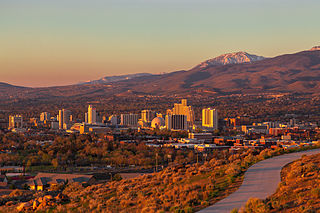
Reno is a city in the northwest section of the U.S. state of Nevada, along the Nevada-California border, about 22 miles (35 km) north from Lake Tahoe, known as "The Biggest Little City in the World". Known for its casino and tourism industry, Reno is the county seat and largest city of Washoe County and sits in the High Eastern Sierra foothills, in the Truckee River valley, on the eastern side of the Sierra Nevada. The Reno metro area occupies a valley colloquially known as the Truckee Meadows which because of large-scale investments from Greater Seattle and San Francisco Bay Area companies such as Amazon, Tesla, Panasonic, Microsoft, Apple, and Google has become a new major technology center in the United States.

<span class="mw-page-title-main">Hot spring</span> Spring produced by the emergence of geothermally heated groundwater

A hot spring, hydrothermal spring, or geothermal spring is a spring produced by the emergence of geothermally heated groundwater onto the surface of the Earth. The groundwater is heated either by shallow bodies of magma or by circulation through faults to hot rock deep in the Earth's crust. In either case, the ultimate source of the heat is radioactive decay of naturally occurring radioactive elements in the Earth's mantle, the layer beneath the crust.

<span class="mw-page-title-main">Geothermal energy</span> Thermal energy generated and stored in the Earth

Geothermal energy is the thermal energy in the Earth's crust which originates from the formation of the planet and from radioactive decay of materials. The high temperature and pressure in Earth's interior cause some rock to melt and solid mantle to behave plastically. This results in parts of the mantle convecting upward since it is lighter than the surrounding rock. Temperatures at the core–mantle boundary can reach over 4000 °C (7200 °F).

<span class="mw-page-title-main">Geothermal areas of Yellowstone</span> Geyser basins and other geothermal features in Yellowstone National Park

The geothermal areas of Yellowstone include several geyser basins in Yellowstone National Park as well as other geothermal features such as hot springs, mud pots, and fumaroles. The number of thermal features in Yellowstone is estimated at 10,000. A study that was completed in 2011 found that a total of 1,283 geysers have erupted in Yellowstone, 465 of which are active during an average year. These are distributed among nine geyser basins, with a few geysers found in smaller thermal areas throughout the Park. The number of geysers in each geyser basin are as follows: Upper Geyser Basin (410), Midway Geyser Basin (59), Lower Geyser Basin (283), Norris Geyser Basin (193), West Thumb Geyser Basin (84), Gibbon Geyser Basin (24), Lone Star Geyser Basin (21), Shoshone Geyser Basin (107), Heart Lake Geyser Basin (69), other areas (33). Although famous large geysers like Old Faithful are part of the total, most of Yellowstone's geysers are small, erupting to only a foot or two. The hydrothermal system that supplies the geysers with hot water sits within an ancient active caldera. Many of the thermal features in Yellowstone build up sinter, geyserite, or travertine deposits around and within them.

<span class="mw-page-title-main">El Tatio</span> Geyser field located in the Andes Mountains, Chile

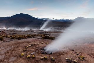
El Tatio is a geothermal field with many geysers located in the Andes Mountains of northern Chile at 4,320 metres (14,170 ft) above mean sea level. It is the third-largest geyser field in the world and the largest in the Southern Hemisphere. Various meanings have been proposed for the name "El Tatio", including "oven" or "grandfather". The geothermal field has many geysers, hot springs, and associated sinter deposits. These hot springs eventually form the Rio Salado, a major tributary of the Rio Loa, and are a major source of arsenic pollution in the river. The vents are sites of populations of extremophile microorganisms such as hyperthermophiles, and El Tatio has been studied as an analogue for the early Earth and possible past life on Mars.

<span class="mw-page-title-main">Beowawe, Nevada</span> Unincorporated community located in the State of Nevada, United States of America

Beowawe is a small town in Eureka County, Nevada, United States.

<span class="mw-page-title-main">Geothermal heating</span> Use of geothermal energy for heating

Geothermal heating is the direct use of geothermal energy for some heating applications. Humans have taken advantage of geothermal heat this way since the Paleolithic era. Approximately seventy countries made direct use of a total of 270 PJ of geothermal heating in 2004. As of 2007, 28 GW of geothermal heating capacity is installed around the world, satisfying 0.07% of global primary energy consumption. Thermal efficiency is high since no energy conversion is needed, but capacity factors tend to be low since the heat is mostly needed in the winter.

<span class="mw-page-title-main">Truckee Meadows</span>

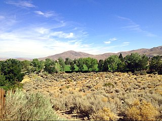
The Truckee Meadows is a valley in Northern Nevada, named for the Truckee River, which collects and drains all water in the valley. Truckee Meadows is also colloquially used as a name for the Reno–Tahoe-Fernley CSA area, even though the metro area includes areas outside this valley. The name for the valley in the Washo language is Welganuk.

<span class="mw-page-title-main">Peppermill Reno</span> Casino hotel in Nevada, United States

Peppermill Reno is a hotel and casino located in Reno, Nevada owned and operated by Peppermill Casinos, Inc.

<span class="mw-page-title-main">Fly Geyser</span> Small geothermal geyser in Nevada

Fly Geyser, also known as Fly Ranch Geyser is a small geothermal geyser located on private land in Washoe County, Nevada, about 20 miles (32 km) north of Gerlach. Fly Geyser is located near the edge of Fly Reservoir in the Hualapai Geothermal Flats and is approximately 5 feet (1.5 m) high by 12 feet (3.7 m) wide, counting the mound on which it sits.

<span class="mw-page-title-main">Geothermal energy in the United States</span> Overview of geothermal power in the United States of America

Geothermal energy was first used for electric power production in the United States in 1960. The Geysers in Sonoma and Lake counties, California was developed into the largest geothermal steam electrical plant in the world, at 1,517 megawatts. Other geothermal steam fields operate in the western US and Alaska.

<span class="mw-page-title-main">Geothermal power</span> Power generated by geothermal energy

Geothermal power is electrical power generated from geothermal energy. Technologies in use include dry steam power stations, flash steam power stations and binary cycle power stations. Geothermal electricity generation is currently used in 26 countries, while geothermal heating is in use in 70 countries.

<span class="mw-page-title-main">Waimangu Volcanic Rift Valley</span> Volcanic Valley in New Zealand

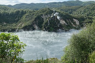
The Waimangu Volcanic Rift Valley is the hydrothermal system created on 10 June 1886 by the volcanic eruption of Mount Tarawera, on the North Island of New Zealand. It encompasses Lake Rotomahana, the site of the Pink and White Terraces, as well as the location of the Waimangu Geyser, which was active from 1900 to 1904. The area has been increasingly accessible as a tourist attraction and contains Frying Pan Lake, which is the largest hot spring in the world, and the steaming and usually pale blue Inferno Crater Lake, the largest geyser-like feature in the world although the geyser itself cannot be seen since it plays at the bottom of the lake.

<span class="mw-page-title-main">U.S. Route 395 Alternate</span> Highway in Nevada

U.S. Route 395 Alternate is a 20.082-mile-long (32.319 km) alternate route of U.S. Route 395 in Washoe County, Nevada.

<span class="mw-page-title-main">Manitou Mineral Springs</span> United States historic place

Manitou Mineral Springs are natural mineral springs in Manitou Springs, Colorado and Cheyenne Spring House is on the National Register of Historic Places. The springs are located in one of the country's largest National Historic Districts.

Brine mining is the extraction of useful materials which are naturally dissolved in brine. The brine may be seawater, other surface water, groundwater, or hyper-saline solutions from several industries. It differs from solution mining or in-situ leaching in that those methods inject water or chemicals to dissolve materials which are in a solid state; in brine mining, the materials are already dissolved.

<span class="mw-page-title-main">Steamboat Creek (Nevada)</span>

Steamboat Creek drains Washoe Lake, flowing north to northeast through Truckee Meadows and finally intersecting the Truckee River, east of Reno, Nevada. Historical documents indicate that in the early 1860s there were at least six mills reducing Comstock ore in Washoe Valley and during these earliest days of the Comstock mining.

<span class="mw-page-title-main">Carson Hot Springs</span>

Carson Hot Springs is a natural hot spring located in Carson City, Nevada in the Eagle Valley. The spring emits approximately 60 gallons of 120° Fahrenheit geothermally heated groundwater per minute, and is the largest hot spring in the Eagle Valley. The groundwater originates at 6.6 miles (10.6 km) below the earth's surface, and the pools at the site are filled with water pumped from the spring. Today, it is a resort that provides private indoor soaking areas, an outdoor swimming pool, massage and dining.

References

  1. 1 2 3 4 "Steamboat Springs". Global Volcanism Program . Smithsonian Institution . Retrieved 2008-09-04.
  2. Wood, Charles A.; Jűrgen Kienle (1993). Volcanoes of North America. Cambridge University Press. pp. 156–258. ISBN   0-521-43811-X.
  3. "Steamboat Hot Springs and Healing Center". Steamboat Hot Springs Healing Center & Spa. Retrieved 2019-11-21.
  4. "Steamboat Hot Springs Healing Center & Spa". Travel Nevada. Retrieved 2019-12-02.
  5. 1 2 3 4 Gowery, Dawn (2010-03-01). "A Steamboat In The Desert". Healthy Beginnings. Retrieved 2019-12-02.
  6. 1 2 3 4 Paher, Stanley W. (1970). Nevada Ghost Towns and Mining Camps. Howell-North Books. p. 41.
  7. 1 2 Carlson, Helen S. (1985). Nevada place names : a geographical dictionary. Reno: University of Nevada Press. p. 223. ISBN   0-87417-094-X.
  8. Collar, Robert Jude (Spring 1990). Causes for the decline of hot spring and geyser activity, Steamboat Springs, Nevada (MSc). San Diego State University . Retrieved February 14, 2023.
  9. Sorey, Michael L. (May 28, 2000). Geothermal Development and Changes in Surficial Features: Examples from the Western United States (PDF). Proceedings World Geothermal Congress 2000. Kyushu - Tohoku, Japan. Retrieved February 14, 2023.
  10. Miller, Martha (June 13, 1990). "Washoe OKs Geothermal Plant Expansion". Reno Gazette-Journal . p. 13. Retrieved February 14, 2023.
  11. "Locations". Cosolargy. Retrieved 2019-12-02.
  12. "Advocates for Religious Rights and Freedoms". arrf.org. Retrieved 2019-12-02.
  13. 1 2 3 Bently Nevada (December 1993). "Steamboat Geothermal Plant". 14 (4). Minden NV: 17.{{cite journal}}: Cite journal requires |journal= (help)
  14. Gowery, Dawn (2010-03-01). "A Steamboat In The Desert". Healthy Beginnings. Retrieved 2019-11-21.