
Wharram Percy is a deserted medieval village and former civil parish near Wharram-le-Street, now in the parish of Wharram, on the western edge of the chalk Wolds of North Yorkshire, England. It is about 1 mile (1.6 km) south of Wharram-le-Street and is signposted from the Beverley to Malton road (B1248). Wharram Percy was part of the East Riding of Yorkshire until the 1974 boundary changes. In 1931 the parish had a population of 40.

Linton is a village in the civil parish of Collingham, in the City of Leeds metropolitan borough, in West Yorkshire, England. It is 1.5 miles (2.4 km) south-west of Wetherby on the north bank of the River Wharfe, Collingham is on the opposite bank.
The Ainsty or the Ainsty of York was a historic district of Yorkshire, England, west of the city of York. Originally a wapentake or subdivision of the West Riding of Yorkshire it later had a unique status as a rural area controlled by the corporation of the city.
Wressle is a village and civil parish in the East Riding of Yorkshire, England, lying on the eastern bank of the River Derwent approximately 3 miles (5 km) north-west of Howden.

Appleton Roebuck is a village and civil parish in the former Selby District of North Yorkshire, England. The village is about 9 miles (14 km) south-west of York. The civil parish includes the hamlets of Holme Green and Nun Appleton, and covers an area of around 2,900 acres (1,200 ha). The parish had a population of 692 according to the 2001 census, increasing to 870 in the 2021 census and including Acaster Selby.

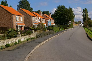
Bolton Percy is a village and civil parish in the Selby District of North Yorkshire, England. According to the 2001 census it had a population of 305 in 115 households, reducing marginally to 304 at the 2011 census. The village is about 4 miles (6.4 km) east of Tadcaster.
Osgodby is a village in the civil parish of Barlby with Osgodby, in North Yorkshire, England, 2 miles (3.2 km) from Selby.

Thwing is a village and civil parish in the Yorkshire Wolds, in the East Riding of Yorkshire, England.

Yapham is a village and civil parish in the East Riding of Yorkshire, Northern England. It is situated about 2 miles (3.2 km) north-east of Pocklington. The parish includes the hamlet of Meltonby and is approximately 1,830 acres (740 ha).
Yokefleet is a hamlet and former civil parish, now in the parish of Blacktoft, in the East Riding of Yorkshire, England. A very small part of Yokefleet is in the civil parish of Laxton. It is situated on the north bank of the River Ouse, downstream from York, Selby and Goole. In 1931 the parish had a population of 102.
Tunstall is a village in the civil parish of Roos, in Holderness, in the East Riding of Yorkshire, England, close to the North Sea coast. It is situated approximately 3 miles (4.8 km) north-west of the town of Withernsea, and less than 0.6 miles (1 km) from the North Sea coast, at a height of 10 to 15 m above sea level, and close to the Prime Meridian at its northernmost point on land anywhere in the world.

Metham is a hamlet in the civil parish of Laxton, in the East Riding of Yorkshire, England. It is situated approximately 3 miles (5 km) south east of Howden and 19 miles (31 km) south east of York. It lies 1.5 miles (2.4 km) north of the River Ouse, downstream from York, Selby and Goole.

Kilnwick Percy is a village and former civil parish, now in the parish of Nunburnholme, in the East Riding of Yorkshire, England. It is situated approximately 1.5 miles (2.4 km) north-east of Pocklington town centre, and to the north of the B1246 road. In 1931 the parish had a population of 69. On 1 April 1935 the parish was abolished and merged with Nunburnholme.

Tosside is a small village on the modern border of North Yorkshire and Lancashire in Northern England. It lies within the Forest of Bowland, and is between the villages of Slaidburn in Lancashire and Wigglesworth in North Yorkshire. It lies 11.5 miles north of Clitheroe and 17 miles north-west of Skipton. The village is 870 feet (270 m) above sea level and lies at 54.0001°N / 2.35436°W on the B6478 road.

Cliffe is a small village and civil parish in North Yorkshire, England. It was historically part of the East Riding of Yorkshire until 1974, but from 1974 to 2023 was in the Selby District of the shire county of North Yorkshire. In 2023 the district was abolished and North Yorkshire became a unitary authority.

Healaugh is a village and civil parish in the former Selby District of North Yorkshire, England. According to the 2001 census it had a population of 161 in 63 households. The population had increased to 249 at the 2011 census. The village is about three miles north north-east of Tadcaster.

Oxton is a village and civil parish in the Selby District of North Yorkshire, England, and about 8 miles (13 km) south-west from the county town and city of York. The parish touches Bolton Percy, Grimston, Kirkby Wharfe with North Milford, Steeton and Tadcaster. In 2001 the parish had a population of 20.

Grimston is a civil parish about 8 miles from York, in North Yorkshire, England. In 2001 the parish had a population of 59. The parish touches Bolton Percy, Kirkby Wharfe with North Milford, Oxton, Stutton with Hazlewood, Tadcaster and Towton. From 1974 to 2023 it was in the Selby district.
Wilstrop is a civil parish about 8 miles (13 km) west of York, in the Harrogate district, in the county of North Yorkshire, England. In 2001 the parish had a population of 44, and in 2015 the population was estimated at 60. There is no modern village in the parish. The site of the deserted medieval village of Wilstrop lies near the River Nidd on the northern boundary of the parish.
Steeton with Eastburn is a civil parish in the metropolitan borough of the City of Bradford, West Yorkshire, England. It contains 25 listed buildings that are recorded in the National Heritage List for England. All the listed buildings are designated at Grade II, the lowest of the three grades, which is applied to "buildings of national importance and special interest". The parish contains the villages of Steeton and Eastburn and the surrounding area. Most of the listed buildings are houses, cottages and associated structures, farmhouses and farm buildings. The other listed buildings include a church, a Sunday school, a road bridge, a former textile mill, three milestones, a commemorative tower, and a pillbox and two fire posts surviving from the Second World War.

