Stones River

Last updated
Stones River
Stones River Watershed Map.png
Map of the Stones River Watershed
Location
Country United States
Physical characteristics
Source 
  locationEast Fork – Short Mountain (Cannon County)
Middle Fork – Hoovers Gap (Rutherford County)
West Fork – Tennessee Valley Divide (Rutherford County)
  elevationEast Fork - 1,120 feet (341.4 m)
Middle Fork - 923 feet (281.3 m)
West Fork - 792 feet (241.4 m)
Mouth  
  location
Cumberland River near Nashville
  coordinates
36°11′30″N86°39′45″W / 36.19167°N 86.66250°W / 36.19167; -86.66250 [1]
  elevation
413 feet (125.9 m) [1]
LengthMain River - 32.4 miles (52.1 km)
East Fork - 54.0 miles (86.9 km)
Middle Fork - 19.8 miles (31.9 km)
West Fork - 39.1 miles (62.9 km)
Basin size921 square miles (2,385.4 km2)

The Stones River (properly spelled Stone's River) [2] is a major stream of the eastern portion of Tennessee's Nashville Basin region [1] and a tributary of the Cumberland River. It is named after explorer and longhunter Uriah Stone, who navigated the river in 1767. [3] [4]

Contents

Geography and hydrography

Stones River along the Murfreesboro Greenway Stones River (195 365).jpg
Stones River along the Murfreesboro Greenway

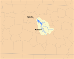
The Stones River is composed of three major forks: the West, Middle, and East forks. The West Fork, 39.1 miles (62.9 km) long, [5] rises in southernmost Rutherford County near the Bedford County line. The upstream portion of its course runs roughly parallel to U.S. Highway 231. The Middle Fork, 19.8 miles (31.9 km) long, [5] rises in an area of low hills, or knobs, also near the line with Bedford County, near Hoovers Gap, an important troop movement route during the American Civil War. It flows roughly parallel to, but west of, Interstate 24 and U.S. Highway 41, and is met by the West Fork near State Route 99. The East Fork is the longest, at 54.0 miles (86.9 km); [5] it rises in Cannon County on Short Mountain, an outlier of the Cumberland Plateau, and flows through Woodbury, the county seat. This stream is roughly paralleled by U.S. Route 70S.

The West Fork runs just west of downtown Murfreesboro. Just northwest of Murfreesboro along the West Fork is the Stones River National Battlefield, site of the Battle of Stones River, a major Civil War battle that was fought from December 31, 1862, to January 2, 1863. The East Fork runs well to the north of Murfreesboro, adjacent to the grounds of the Alvin C. York Veterans Affairs hospital, and is crossed by U.S. Highway 231 near the community of Walterhill, site of a former hydroelectric dam used for a power supply for the surrounding area prior to the advent of the Tennessee Valley Authority. Near this site is a gigantic landfill operated by Browning-Ferris Industries.

Reservoir

The confluence of the two major forks occurs in northeastern Rutherford County near Smyrna. At the confluence, both are already somewhat slack because of the impoundment of J. Percy Priest Dam, a United States Army Corps of Engineers development constructed during the 1960s and named for a former Nashville Congressman. The impoundment of the reservoir led to major change in residential growth patterns in Nashville during the late 1960s and 1970s because people desired to live near the lake, which is highly developed with boat ramps, marinas, parks and other recreational areas, campgrounds, and even an artificial beach area.

In 1979 the dam was bombed with dynamite as ruse to cover a crime spree supposed to have taken place in the resultant massive flooding. The conspirators succeeded only in destroying some iron doors at the dam's base. The suspects were later convicted and sentenced to substantial prison terms. [6]

The Stone Rivers Pedestrian Greenway Bridge in Nashville Stones River Pedestrian Greenway Bridge, Nashville.jpg
The Stone Rivers Pedestrian Greenway Bridge in Nashville

The dam is visible from the bridge just below it on Interstate 40; just below the dam is a desirable fishing area under certain discharge conditions, but in recent years access has at times been limited because of security concerns. Also just below the dam is the trail-head of the Stones River Greenway, an important part of the Nashville Greenways Project. [7]

Tailwaters

Between Percy Priest Dam and the mouth of the Stones River, the river flows through Clover Bottom, a large flood plain and site of a former plantation whose Clover Bottom Mansion house, after many years of disuse, neglect, and vandalism, is now the headquarters for the Tennessee Historical Commission. "Clover Bottom" was once the name of a nearby custodial school for mentally disabled children and adults. The immediate area is also the site of a state mental hospital and the Tennessee School for the Blind. Clover Bottom also is the separation of the Nashville neighborhoods of Donelson and Hermitage.

Near the mouth of the Stones River into the Cumberland River, below the bridge on U.S. Highway 70, is a private golf club. The Stones River is now thought of primarily in terms of its major impoundment, Percy Priest Lake, and is important to the Nashville area. The flood control provided by the dam has been important to the reduction of flooding downstream in the downtown Nashville area, as well as in the entire Cumberland Valley. [8]

See also

Related Research Articles

<span class="mw-page-title-main">Cumberland River</span> River in Kentucky and Tennessee, United States

The Cumberland River is a major waterway of the Southern United States. The 688-mile-long (1,107 km) river drains almost 18,000 square miles (47,000 km2) of southern Kentucky and north-central Tennessee. The river flows generally west from a source in the Appalachian Mountains to its confluence with the Ohio River near Paducah, Kentucky, and the mouth of the Tennessee River. Major tributaries include the Obey, Caney Fork, Stones, and Red Rivers.

<span class="mw-page-title-main">Percy Priest</span> American journalist

James Percy Priest was an American teacher, journalist and politician who represented Tennessee in the United States House of Representatives from 1941 until his death.

<span class="mw-page-title-main">Rocky River (Tennessee)</span> River in Tennessee, United States

The Rocky River is a 31.0-mile-long (49.9 km) stream in the east-central portion of Middle Tennessee in the United States. It is a tributary of the Caney Fork River, and is part of the Cumberland, Ohio and Mississippi watersheds. The lower portion of the river is part of the reservoir created by Great Falls Dam, which is located near the river's confluence with the Caney Fork.

<span class="mw-page-title-main">Falling Water River</span> River in Tennessee, United States

The Falling Water River is a 46.8-mile-long (75.3 km) stream in the east-central portion of Middle Tennessee in the United States. It rises just west of Monterey at the edge of the Cumberland Plateau, and traverses the Eastern Highland Rim before dropping off to the Nashville Basin and emptying into Center Hill Lake along the Caney Fork. The river is noted for the 136-foot (41 m) Burgess Falls, which it spills over near the end of its course.

<span class="mw-page-title-main">Caney Fork River</span> River in Tennessee, United States

The Caney Fork River is a river that flows through central Tennessee in the United States, draining a substantial portion of the southwestern Cumberland Plateau and southeastern Highland Rim regions. It is a major tributary of the Cumberland River, and is part of the Cumberland, Ohio and Mississippi basins. The river is 143 miles (230 km) long, and its watershed covers 1,771 square miles (4,590 km2) in eleven counties. Monterey, Baxter, Sparta, Smithville, McMinnville, Altamont, Spencer and Gordonsville are among the towns that are at least partially drained by the river.

The Obey River is a 47.8-mile-long (76.9 km) tributary of the Cumberland River in the U.S. state of Tennessee. It joins the Cumberland River near the town of Celina, which is generally considered to be the Cumberland's head of navigation. Via the Cumberland and Ohio rivers, the Obey River is part of the Mississippi River watershed.

<span class="mw-page-title-main">Hermitage, Tennessee</span> Neighborhood in Davidson, Tennessee, United States

Hermitage, Tennessee, is located in eastern Davidson County, adjacent to – and named in honor of – The Hermitage, the historic home of Andrew Jackson, seventh President of the United States. Although the area is incorporated as part of the Metropolitan Government of Nashville and Davidson County, it maintains its own identity as a residential and commercial suburban area.

<span class="mw-page-title-main">Rock Island State Park (Tennessee)</span> Park in Warren and White Counties, Tennessee, United States

Rock Island State Park is a state park in Warren County and White County, Tennessee, located in the Southeastern United States. The park is named after the community of Rock Island, Tennessee, which in turn received its name from an island on the Caney Fork upstream from the Collins River confluence and Great Falls Dam. Rock Island State Park is centered on a peninsula created by the confluence of these two rivers and extends downstream to the headwaters of Center Hill Lake.

<span class="mw-page-title-main">Edgar Evins State Park</span> State park in Tennessee, United States

Edgar Evins State Park is a state park in DeKalb County, Tennessee, in the southeastern United States. The park consists of 6,300 acres (25 km2) along the shores of Center Hill Lake, an impoundment of the Caney Fork. The State of Tennessee leases the land from the U.S. Army Corps of Engineers.

<span class="mw-page-title-main">Center Hill Lake</span> Reservoir in Tennessee, United States

Center Hill Lake is a reservoir in the U.S. state of Tennessee. It is located in Middle Tennessee near Smithville. Created by means of a dam constructed by the U.S. Army Corps of Engineers in 1948, the lake has a dual purpose: electricity production and flood control. Center Hill Dam is 260 ft (79 m) high, and it is composed of concrete and earth structures, with 8 gates that are 50 ft (15 m) wide each. Center Hill Lake is one of four major flood control reservoirs for the Cumberland; the others being Percy Priest Lake, Dale Hollow Reservoir, and Lake Cumberland.

<span class="mw-page-title-main">Percy Priest Lake</span> Reservoir in Davidson, Rutherford, and Wilson Counties, Tennessee, United States

J. Percy Priest Lake is a reservoir in north central part of Tennessee. It is formed by J. Percy Priest Dam, located between miles six and seven of the Stones River. The dam is located about 10 miles (16 km) east of downtown Nashville and impounds a lake 42 mi (68 km) long. The lake and dam are named for Congressman Percy Priest.

<span class="mw-page-title-main">J. Percy Priest Dam</span> Dam in Tennessee

J. Percy Priest Dam is a dam in north central Tennessee at river mile 6.8 of the Stones River, a tributary of the Cumberland. It is located about ten miles (16 km) east of downtown Nashville. The reservoir behind the dam is Percy Priest Lake. It is one of four major flood control reservoirs for the Cumberland; the others being Wolf Creek Dam, Dale Hollow Dam, and Center Hill Dam.

<span class="mw-page-title-main">Robert Weakley</span> American politician (1764–1845)

Robert Weakley was an American politician who represented Tennessee in the United States House of Representatives from 1809 to 1811.

<span class="mw-page-title-main">Nashville metropolitan area</span> Metropolitan area in Tennessee, United States

The Nashville metropolitan area is a metropolitan statistical area in north-central Tennessee. Its principal city is Nashville, the capital of and largest city in Tennessee. With a population of over 2 million, it is the most populous metropolitan area in Tennessee. It is also the largest metropolitan area in Tennessee in terms of land area.

<span class="mw-page-title-main">Longhunter</span> Frontier hunters in Kentucky and Tennessee

A longhunter was an 18th-century explorer and hunter who made expeditions into the American frontier for as much as six months at a time.

<span class="mw-page-title-main">Great Falls Dam (Tennessee)</span> Hydroelectric dam in Tennessee

Great Falls Dam is a hydroelectric dam on the Caney Fork, straddling the county line between White County and Warren County in the U.S. state of Tennessee. It is the only dam outside the Tennessee River watershed owned and operated by the Tennessee Valley Authority. The dam impounds the 1,830-acre (740 ha) Great Falls Lake, and its tailwaters feed into Center Hill Lake. The completion of Great Falls Dam in late 1916 was an engineering triumph, marking the first successful attempt to impound the volatile and flood-prone Caney Fork. The dam is also notable for its design, utilizing a mostly underground conduit to carry water from the reservoir via a tributary to the Power House 0.75 miles (1.21 km) downstream from the dam.

<span class="mw-page-title-main">Standing Stone State Park</span> State Park in Overton County, Tennessee, United States of America

Standing Stone State Park is a state park in Overton County, Tennessee, in the southeastern United States. The park consists of 855 acres (3.46 km2) along the shoreline of the man-made 69-acre (0.28 km2) Standing Stone Lake. The 11,000-acre (45 km2) Standing Stone State Forest surrounds the park.

<span class="mw-page-title-main">Cove Lake State Park</span> State park in Tennessee, United States

Cove Lake State Park is a state park in Campbell County, Tennessee, in the southeastern United States. The park consists of 673 acres (2.72 km2) situated around Cove Lake, an impoundment of Cove Creek created by the completion of Caryville Dam in 1936. The park's location is in the town of Caryville and west of Jacksboro.

<span class="mw-page-title-main">Long Hunter State Park</span> State park in Tennessee, United States

Long Hunter State Park is a state park in Davidson County and Rutherford County, Tennessee, located in the southeastern United States. The park is mostly situated along the eastern shores of Percy Priest Lake, an artificial lake created by an impoundment of the Stones River.

Old Hickory Boulevard is a historic road that encircles Nashville, Tennessee, lying entirely within Davidson County. Originally the road, aided by ferries, formed a nearly unbroken loop around the city. Today, it is interrupted by a lake and several rerouted sections, which consist of roughly 69 miles (111 km). Just over half the distance–36.2 miles (58.3 km)–is part of several Tennessee state highways, including SR 45, SR 171, SR 251, and SR 254. Unsigned concurrencies exist very briefly along US 31E, US 41/US 70S, and SR 100.

References

  1. 1 2 3 U.S. Geological Survey Geographic Names Information System: Stones River
  2. Stones River History
  3. Collins, Lewis (1877). History of Kentucky. p. 417.
  4. Name: Uriah Stone?
  5. 1 2 3 U.S. Geological Survey. National Hydrography Dataset high-resolution flowline data. The National Map, accessed June 8, 2011
  6. Reading Eagle, January 7, 1979
  7. Nashville-Davidson County government's Nashville Greenways Project website
  8. "Nashville District > Locations > Dams > J. Percy Priest Dam". www.lrn.usace.army.mil. Retrieved 2024-04-02.