Stony Creek, New York

Last updated

Stony Creek
Stony Creek New York.PNG
Location of Stony Creek in Warren County
USA New York location map.svg
Red pog.svg
Stony Creek
Location within the state of New York
Coordinates: 43°25′36″N73°57′42″W / 43.42667°N 73.96167°W / 43.42667; -73.96167
Country United States
State New York
County Warren
Area
[1]
  Total83.20 sq mi (215.50 km2)
  Land82.16 sq mi (212.80 km2)
  Water1.04 sq mi (2.70 km2)
Elevation
2,418 ft (737 m)
Population
 (2010)
  Total767
  Estimate 
(2016) [2]
747
  Density9.09/sq mi (3.51/km2)
Time zone UTC-5 (Eastern (EST))
  Summer (DST) UTC-4 (EDT)
ZIP code
12878
Area code 518
FIPS code 36-71641
GNIS feature ID0979531
Website Town website

Stony Creek is a town in the southwestern part of Warren County, New York, United States. It is northwest of the city of Glens Falls and is part of the Glens Falls Metropolitan Statistical Area. [3] The population was 767 at the 2010 census. The town is named for a creek that flows through it.[ citation needed ] Stony Creek is within the Adirondack Park.

Contents

History

The town was first settled circa 1795. Stony Creek was established as a town in 1852 from a portion of the Town of Warrensburg called "Athol."

In the late 1800s and early 1900s, when a tannery existed at the confluence of Roaring Branch and Stony Creek near the center of town, the peak population of 1,250 was attained. During that time, extensive logging was done in western Stony Creek. Once many of the hemlock trees were taken out, and tanning practices changed, the tannery closed and Stony Creek's population decreased significantly and has remained at lower levels since then.

The center of town referred to by residents as the "four corners" (where the roads from nearby towns Hadley and Warrensburg intersect and continue on to Wilcox Lake/Harrisburg and Lens Lake, both of which terminate at those destinations) includes the main business and social area of town. The Stony Creek Inn, the Creek Center Mercantile and the Post Office now occupy three of the four corners and a small park adjacent at Roaring Branch occupies the fourth.

In addition to the four corners, the other main area of activity in Stony Creek is the John T. O'Neill Green Meadows Park (aka "rec field") which is situated just west of the four corners and along Stony Creek itself. The rec field includes a swimming hole (below a small low-head dam on Stony Creek), basketball court, softball diamond and backstop, a large pavilion under which every Tuesday night in July and August the town presents Music in the Park, playground and covered area with picnic tables.

The "rec" field is also the site of the long-running annual Mountain Festival. In the past, the original Mountain Days celebrated the 100th anniversary of the town and paid homage to the area's rich logging tradition, attracting thousands of attendees. It included competitions such as the greased pole climb (where competitors stood on each others' shoulders to get to the top of a debarked, greased pole where a $100 bill was nailed), chainsaw and bandsaw speed competitions, wood chopping competitions, axe throwing competitions, and greased pig chases. In recent years, Mountain Days, now called Mountain Festival, has become a more traditional and smaller festival, with music, food and activities for kids and stands selling various local arts and crafts. The festival continues to grow with added attractions each year.

The Methodist Episcopal Church was added to the National Register of Historic Places in 2010. [4]

Geography

According to the United States Census Bureau, the town has a total area of 83.2 square miles (215 km2), of which 82.4 square miles (213 km2) is land and 0.8 square miles (2.1 km2) (1.01%) is water.

The southern town line is the border of Saratoga County. The eastern town boundary is marked by the Hudson River, and the western town line is the border of Hamilton County.

Adjacent towns and areas

The southern town line borders the towns of Day and Hadley in Saratoga County. The western town boundary is shared by the town of Wells in Hamilton County. To the north is the town of Thurman and the eastern town line is shared with the town of Warrensburg.

Demographics

Historical population
CensusPop.Note
1860 960
1870 1,12717.4%
1880 1,25311.2%
1890 1,3427.1%
1900 1,019−24.1%
1910 858−15.8%
1920 651−24.1%
1930 464−28.7%
1940 457−1.5%
1950 4794.8%
1960 459−4.2%
1970 56022.0%
1980 528−5.7%
1990 67026.9%
2000 74310.9%
2010 7673.2%
2016 (est.)747 [2] −2.6%
U.S. Decennial Census [5]

As of the census [6] of 2000, there were 743 people, 297 households, and 204 families residing in the town. The population density was 9.0 people per square mile (3.5/km2). There were 513 housing units at an average density of 6.2 per square mile (2.4/km2). The racial makeup of the town was 97.31% White, 0.94% Native American, 0.54% Asian, 0.13% from other races, and 1.08% from two or more races. Hispanic or Latino of any race were 1.48% of the population.

There were 297 households, out of which 28.6% had children under the age of 18 living with them, 53.9% were married couples living together, 8.8% had a female householder with no husband present, and 31.0% were non-families. 25.9% of all households were made up of individuals, and 12.8% had someone living alone who was 65 years of age or older. The average household size was 2.46 and the average family size was 2.95.

In the town, the population was spread out, with 23.1% under the age of 18, 6.5% from 18 to 24, 28.7% from 25 to 44, 26.4% from 45 to 64, and 15.3% who were 65 years of age or older. The median age was 40 years. For every 100 females, there were 107.5 males. For every 100 females age 18 and over, there were 110.7 males.

The median income for a household in the town was $32,946, and the median income for a family was $36,111. Males had a median income of $28,393 versus $23,929 for females. The per capita income for the town was $14,654. About 10.4% of families and 16.3% of the population were below the poverty line, including 19.6% of those under age 18 and 8.5% of those age 65 or over.

Communities and locations in Stony Creek

Related Research Articles

<span class="mw-page-title-main">Mina, New York</span> Town in New York, United States

Mina is a town in Chautauqua County, New York, United States. The population was 1,004 at the 2020 census. It is at the western county border and state line. The town is best known as a summer resort area, centered on the hamlet of Findley Lake.

<span class="mw-page-title-main">Villenova, New York</span> Town in New York, United States

Villenova is a town in Chautauqua County, New York, United States. The population was 1,053 at the 2020 census. The town is on the eastern border of the county and is southeast of Dunkirk.

<span class="mw-page-title-main">Sardinia, New York</span> Town in New York, United States

Sardinia is a town in Erie County, New York, United States. The town lies in the southeast corner of Erie County and is considered one of the county's "Southtowns". The town is southeast of Buffalo. The population was 2,775 at the 2010 census. The town is reportedly named after an old Christian hymn, Sardinia, and the homonymous Mediterranean island.

<span class="mw-page-title-main">Bleecker, New York</span> Town in New York, United States

Bleecker is a town in Fulton County, New York, United States. The population was 533 at the 2010 census. The name is from Barent Bleecker, one of the original landowners of the region.

Oppenheim is a town in Fulton County, New York, United States. The town is in the southwestern corner of the county and is east of Utica. The population was 1,924 at the 2010 census.

<span class="mw-page-title-main">Stratford, New York</span> Town in New York, United States

Stratford is a town in Fulton County, New York, United States. The population was 610 at the 2010 census. The town is in the northwestern corner of the county, northeast of the village of Dolgeville. It was named after Stratford, Connecticut.

<span class="mw-page-title-main">Darien, New York</span> Town in Genesee County, New York

Darien is a town in Genesee County, New York, United States. The population was 3,010 at the 2020 census. Darien lies in the southwestern part of Genesee County, southwest of Batavia.

Henderson is a town in Jefferson County, New York, United States. The population was 1,360 at the 2010 census. The town is named after William Henderson, the original European-American land owner.

Hounsfield is a town in Jefferson County, New York, United States. The population was 3,466 at the 2010 census. The name of the town is from Ezra Hounsfield, a land agent and land owner.

<span class="mw-page-title-main">Porter, New York</span> Town in New York, United States

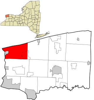
Porter is a town in Niagara County, New York, United States. The population was 6,771 at the 2010 census. The town was named after Judge Augustus Porter.

<span class="mw-page-title-main">Vienna, New York</span> Town in New York, United States

Vienna is a town in Oneida County, New York, United States. The population was 5,440 at the 2010 census. The town is named after the capital of Austria.

<span class="mw-page-title-main">Edmeston, New York</span> Town in New York, United States

Edmeston is a town located in Otsego County, New York, United States. As of the 2010 census, the town had a total population of 1,826.

<span class="mw-page-title-main">Otsego, New York</span> Town in New York, United States

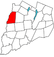
Otsego is a town in the north-central part of Otsego County, New York, United States. The population was 3,641 at the 2020 census. The town is named after Lake Otsego, which forms part of the town's eastern border.

<span class="mw-page-title-main">Roseboom, New York</span> Town in New York, United States

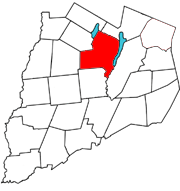
Roseboom is a town in Otsego County, New York, United States. The population was 711 at the 2010 census. The name of the town is taken from those of early landowners and settlers Abram and John Roseboom.

<span class="mw-page-title-main">Macomb, New York</span> Town in New York, United States

Macomb is a town in St. Lawrence County, New York, United States. The population was 906 at the 2010 census. The town is named after Alexander Macomb, who once owned much of northern New York as Macomb's Purchase.

Dansville is a town in Steuben County, New York, United States, not to be confused with the nearby village of Dansville in Livingston County. The population was 1,842 at the 2010 census. The town was named after Daniel Faulkner.

<span class="mw-page-title-main">Thurman, New York</span> Town in New York, United States

Thurman is a town in the western part of Warren County, New York, United States. It is part of the Glens Falls Metropolitan Statistical Area. The town population was 1,199 at the 2000 census. The town is named after John Thurman, an early landowner. The town lies entirely inside the Adirondack Park.

<span class="mw-page-title-main">Java, New York</span> Town in New York, United States

Java is an incorporated town in Wyoming County, New York. The population was 2,057 at the 2010 census. The Town of Java is on the western border of Wyoming County.

Allegany is a town in Cattaraugus County, New York, United States. The population was 7,493 at the 2020 census.

<span class="mw-page-title-main">Adams, New York</span> Town in New York, United States

Adams is a town in Jefferson County, New York, United States. Named after President John Adams, the town had a population of 5,143 at the 2010 census. The town contains a village also named Adams. The village and town are south of Watertown.

References

  1. "2016 U.S. Gazetteer Files". United States Census Bureau. Retrieved July 5, 2017.
  2. 1 2 "Population and Housing Unit Estimates" . Retrieved June 9, 2017.
  3. "Metropolitan Areas and Components, 1999, with FIPS Codes". US Census Bureau. Retrieved July 7, 2009.
  4. "National Register of Historic Places". WEEKLY LIST OF ACTIONS TAKEN ON PROPERTIES: 2/16/10 THROUGH 2/19/10. National Park Service. February 26, 2010.
  5. "Census of Population and Housing". Census.gov. Retrieved June 4, 2015.
  6. "U.S. Census website". United States Census Bureau . Retrieved January 31, 2008.