
The Stort Valley Way is a long-distance footpath in west Essex, England. The 30-mile (48 km) circular path is centred on Harlow and the Stort Navigation. It is waymarked, and named on Ordnance Survey mapping.
The Stort Valley Way is a long-distance footpath in west Essex, England. The 30-mile (48 km) circular path is centred on Harlow and the Stort Navigation. It is waymarked, and named on Ordnance Survey mapping.
The name Stort Valley Way refers to the River Stort, which rises near Langley, Essex, and is navigable from Bishop’s Stortford downstream (the Stort Navigation) to its confluence with the River Lea near Rye House. [1] The way is a circular path centred on Harlow, together with villages to the south and south-east. [1]
The circular walk can be started at several locations and can follow a clockwise or anti-clockwise direction. The route goes through both rural and some urban areas. These include fields, pasture, water meadow and woodland; along rural roads and through villages and some built-up areas. A significant part of the walk is along the towing path of the Stort Navigation. [1]
The path is waymarked in both directions by a dark green circular marker with a white or yellow arrow, a dragonfly and the text ‘Stort Valley Way’. [2]
Roydon, Harlow Town, Harlow Mill and Sawbridgeworth railway stations are close to the walk, and some villages have a bus service. [1]
The Stort Valley Way passes through the following locations (the order assumes starting at Roydon in a clockwise direction): [3] Roydon, Harlow, Sawbridgeworth, Lower Sheering, Sheering, Matching, Matching Tye, Loyter’s Green, Magdalen Laver, Hastingwood, Latton Bush, Rye Hill, Epping Green, Bumbles Green, Nazeing, Nazeingwood Common, Roydon Hamlet and Roydon.
The Stort Valley Way adjoins three long-distance paths: [3]

Epping Forest District is a local government district in Essex, England. It is named after the ancient woodland of Epping Forest, a large part of which lies within the district. The district covers northeastern parts of the London urban area, including the towns of Epping, Loughton, Waltham Abbey, Chigwell, and Buckhurst Hill, as well as rural areas beyond it. The district is situated in the west of the county, bordering north-eastern Greater London.

The Stort Navigation is the canalised section of the River Stort running 22 kilometres (14 mi) from the town of Bishop's Stortford, Hertfordshire, downstream to its confluence with the Lee Navigation at Feildes Weir near Rye House, Hoddesdon, Hertfordshire.

Roydon is a village located in the Epping Forest district of the county of Essex, England. It is located 2 miles (3.2 km) west of Harlow, 4 miles (6.4 km) east of Hoddesdon and 5 miles (8.0 km) northwest of Epping, forming part of the border with Hertfordshire.
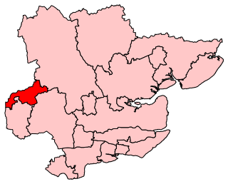
Harlow is a constituency represented in the House of Commons of the UK Parliament since 2010 by Robert Halfon, a Conservative.
The Essex Way is a waymarked long-distance footpath 81 miles (130 km) long, along footpaths and roads in Essex, England.

The River Stort is a river in Essex and Hertfordshire, England. It is 24 miles (38 km) long and flows from just south of the village of Langley to the River Lea at Hoddesdon.

Sheering is a civil parish and village in the Epping Forest district of Essex, England. Sheering village is situated 2.8 miles (5 km) north-east from Harlow, 4.5 miles (7 km) south of Bishop's Stortford and 25 miles (40 km) north-east from London. The Stort Navigation to the west has a lock at Sheering Mill. Lower Sheering, adjacent to Sawbridgeworth in Hertfordshire and its railway station, forms part of the civil parish.
Lower Sheering is a residential dormitory area based on Sheering Lower Road, in the civil parish of Sheering, and the Epping Forest District of Essex, England. It conjoins the Hertfordshire town of Sawbridgeworth at the north-east of the Essex town of Harlow.

Matching is a village and civil parish in the Epping Forest district of Essex, England centred in countryside 3 miles (4.8 km) east of Harlow's modern town centre and 2 miles (3.2 km) from Old Harlow/Harlow Mills area of the town. The terrain is elevated and London is centred 21.7 miles (34.9 km) to the south-west.

Matching Tye is a village which forms part of the civil parish of Matching, in the County of Essex, England. It is 2.3 miles (3.7 km) east of Harlow, 2.9 Miles (4.8 km) south-east of Sawbridgeworth and 6.3 miles (10.4 km) north-east of Epping.
Harlow District Council is the local authority for Harlow in Essex, England. Harlow is a non-metropolitan district, covering just the town of Harlow itself. The council generally styles itself Harlow Council.

Hunsdon Mead is a 34 hectare biological Site of Special Scientific Interest (SSSI) west of Harlow and east of Roydon in Essex. The site is partly in Essex and partly in Hertfordshire, and it is jointly owned and managed by the Essex Wildlife Trust and the Herts and Middlesex Wildlife Trust. The SSSI also includes part of the neighbouring Roydon Mead. The planning authorities are East Hertfordshire District Council and Epping Forest District Council. Hunsdon Mead is registered common land.

Pincey Brook is a watercourse in the Uttlesford and Epping Forest districts of Essex, England, and is a tributary to the River Stort.

The Harcamlow Way is a waymarked walking route in England running in a figure-of-eight from Harlow to Cambridge and back again, hence its portmanteau name. On the way it runs through Essex, Hertfordshire and Cambridgeshire. The route is 141 miles (227 km) long.
St Peter's Way is a long-distance footpath in Essex, England. The 41-mile (66 km) path leads from Chipping Ongar to the 7th-century Chapel of St Peter-on-the-Wall at Bradwell-on-Sea. It is waymarked, and shown on Ordnance Survey mapping.

The Saffron Trail is a long-distance footpath in Essex, England. The 71-mile (114 km) path leads from the pier in Southend-on-Sea to St Mary's church in Saffron Walden. It is waymarked, and shown on Ordnance Survey mapping.

The Three Forests Way is a long-distance footpath in Essex and Hertfordshire, England. The 59-mile (95 km) circular path passes through three forests in west Essex. It is waymarked, and named on Ordnance Survey mapping.
The Roach Valley Way is a long-distance footpath in south-east Essex, England. The 23-mile circular path is centred on Rochford and the River Crouch and Roach estuaries. It is waymarked, and named on Ordnance Survey mapping.
This article is about the Forest Way in Essex. For the Forest Way in Sussex, see Forest Way. Not to be confused with Three Forests Way.
The Epping Forest Centenary Walk is a long-distance footpath from East London to Epping Forest. It is also known as Epping Forest Big Walk. The 15-mile (24 km) path runs from Manor Park to Epping Forest using, where possible, green corridors.