
Harlow is a town and local government district located in the west of Essex, England. Founded as a new town, it is situated on the border with Hertfordshire and London, Harlow occupies a large area of land on the south bank of the upper Stort Valley, which has been made navigable through other towns and features a canal section near its watermill.

Loughton is a town and civil parish in the Epping Forest District of Essex, England. Situated 12 miles (19 km) north-east of Charing Cross, the town borders Waltham Abbey, Theydon Bois, Chigwell, Chingford, and Buckhurst Hill. For statistical purposes it is included in the metropolitan and urban area of London.
Epping Forest District is a local government district in Essex, England. It is named after the ancient woodland of Epping Forest, a large part of which lies within the district. The council is based in the town of Epping. The district also includes the towns of Loughton, Ongar and Waltham Abbey and surrounding rural areas. The district is situated in the west of the county, bordering the north-eastern edge of London.

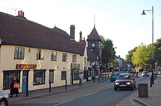
Chipping Ongar is a market town and former civil parish, now in the parish of Ongar, in the Epping Forest District of the county of Essex, England. It is located 6 miles (10 km) east of Epping, 7 miles (11 km) southeast of Harlow and 7 miles (11 km) northwest of Brentwood. In 2020 the built-up area had an estimated population of 6420.

Buckhurst Hill is a suburban village in the Epping Forest district of Essex, England. It is part of the Greater London Urban Area and adjacent to the northern boundary of the London Borough of Redbridge. The area developed following the opening of a railway line in 1856, originally part of the Eastern Counties Railway and now on the Central line of the London Underground.

Waltham Abbey is a town and civil parish in the Epping Forest District of Essex, within the metropolitan and urban area of London, England, 13.5 miles (21.7 km) north-east of Charing Cross. It lies on the Greenwich Meridian, between the River Lea in the west and Epping Forest in the east, with large sections forming part of the Metropolitan Green Belt.

Roydon is a village located in the Epping Forest district of the county of Essex, England. It is located 2 miles (3.2 km) west of Harlow, 4 miles (6.4 km) east of Hoddesdon and 5 miles (8.0 km) northwest of Epping, forming part of the border with Hertfordshire.
Theydon Bois is a village and civil parish in the Epping Forest district of Essex, England. It is 1 mile (1.6 km) south of Epping, 1 mile (1.6 km) northeast of Loughton and 6 miles (9.7 km) south of Harlow. The population was 4,062 as at the 2011 Census.

North Weald Bassett, or simply North Weald, is a village and civil parish in the Epping Forest district of Essex, England. The village is within the North Weald Ridges and Valleys landscape area.

Sheering is a civil parish and village in the Epping Forest district of Essex, England. Sheering village is situated 2.8 miles (5 km) north-east from Harlow, 4.5 miles (7 km) south of Bishop's Stortford and 25 miles (40 km) north-east from London. The Stort Navigation to the west has a lock at Sheering Mill. Lower Sheering, adjacent to Sawbridgeworth in Hertfordshire and its railway station, forms part of the civil parish.

Moreton is a village in the Epping Forest district of the County of Essex, England. It is located 7.2 miles (11.6 km) east of Harlow and 3.2 miles (5.14 km) north-west of Chipping Ongar.

Nazeing is a village and parish in Essex, England. Within the parish are the separate settlements of Upper Nazeing, Middle Nazeing, and Lower Nazeing. The Prime Meridian passes to the west of Lower Nazeing.

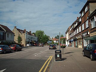
Epping is a market town and civil parish in the Epping Forest district of the county of Essex, England. The town is 17 miles (30 km) northeast from the centre of London, is surrounded by the northern end of Epping Forest, and on a ridge of land between the River Roding and River Lea valleys.

Clatterford End is hamlet in the civil parish of Stanford Rivers, and in the Epping Forest district of Essex, England. The hamlet is situated between the parish villages of Toot Hill and Stanford Rivers. It should not be confused with Clatterford End, Fyfield or Clatterford End, High Easter.

Toot Hill is a village in the Stanford Rivers civil parish in the Epping Forest district of Essex, England. It is 2.3 miles (4 km) south-west of Chipping Ongar and 3.5 miles (6 km) east of Epping. Toot Hill is less than a mile from the small hamlet of Clatterford End.

Hastingwood is a hamlet in the North Weald Bassett civil parish of the Epping Forest district of Essex, England. The hamlet is centred on the junction of Hastingwood Road, which runs southwest to the A414 road and the Hastingwood Junction 7 of the M11 motorway, and Mill Street, which runs north to Harlow Common and Potter Street. Nearby settlements include the town of Harlow, North Weald and the hamlet of Foster Street.

High Beach is a village inside Epping Forest in south-west Essex, England. Part of the civil parish of Waltham Abbey, the village is within the Epping Forest District and the ward of Waltham Abbey High Beach, and lies approximately 11 miles (18 km) north-east of Charing Cross.

Epping Upland is a village and civil parish in the Epping Forest district of Essex, England.

Coopersale, also termed Coopersale Common, is a village in the civil parish of Epping, within the Epping Forest District of Essex, England. In 2018 it had an estimated population of 1019.

Jacks Hatch, is a hamlet in the Epping Upland civil parish of the Epping Forest district of Essex, England.


