Stovall, North Carolina

Last updated

Stovall, North Carolina
NCMap-doton-Stovall.PNG
Location of Stovall, North Carolina
Coordinates: 36°26′51″N78°34′08″W / 36.44750°N 78.56889°W / 36.44750; -78.56889
Country United States
State North Carolina
County Granville
Incorporated1883
Named for John W. Stovall [1]
Area
[2]
  Total1.05 sq mi (2.71 km2)
  Land1.05 sq mi (2.71 km2)
  Water0.00 sq mi (0.00 km2)
Elevation
[3]
476 ft (145 m)
Population
 (2020)
  Total324
  Density309.46/sq mi (119.53/km2)
Time zone UTC-5 (Eastern (EST))
  Summer (DST) UTC-4 (EDT)
ZIP code
27582
Area code 919
FIPS code 37-65320 [4]
GNIS feature ID2406673 [3]

Stovall is a town in Granville County, North Carolina, United States. The population was 418 as of the 2010 census. [5]

Contents

History

Abrams Plains, Maurice Hart House, Hill Airy and John W. Stovall Farm are listed on the National Register of Historic Places. [6]

John Penn, one of the original signatories of the United States Declaration of Independence, lived just two miles east of Stovall. His estate and former grave site are now maintained by the DAR.

Stovall's Railroad Station Stovall's Railroad station.jpg
Stovall's Railroad Station

Geography

According to the United States Census Bureau, the town has a total area of 1.0 square mile (2.6 km2): all land.

Stovall is located in the Sassafras Fork voting precinct in Granville County.

Demographics

Historical population
CensusPop.Note
1910 305
1920 41435.7%
1930 4150.2%
1940 4150.0%
1950 410−1.2%
1960 57039.0%
1970 405−28.9%
1980 4173.0%
1990 409−1.9%
2000 376−8.1%
2010 41811.2%
2020 324−22.5%
U.S. Decennial Census [7]

As of the 2010 census, [4] there were 418 people and 170 households. The population density was 418.0 inhabitants per square mile (161.4/km2). There were 191 housing units at an average density of 191.0 per square mile (73.7/km2). The racial makeup of the town was 54.5% White, 41.4% African American, 4.1% from other races. Hispanic or Latino of any race were 3.8% of the population.

There were 170 households, out of which 25.3% had children under the age of 18 living with them. In the town, the population was spread out, with 24.6% under the age of 18, 9.1% from 18 to 24, 9.3% from 25 to 34, 18.7% from 35 to 49, 18.7% from 50 to 64, and 19.6% who were 65 years of age or older. For every 100 females, there were 96.2 males.

The median income [8] for a household in the town was $35,313, and the mean income for a household was $46,795. The median and mean family incomes were $55,938 and $68,693, respectively. The per capita income for the town was $24,117. About 6.9% of families and 10.9% of the population were below the poverty line, including 12.5% of those under age 18 and 11.3% of those age 65 or over.

Related Research Articles

<span class="mw-page-title-main">Halifax County, Virginia</span> County in Virginia, United States

Halifax County is a county located in the Commonwealth of Virginia. As of the 2020 census, the population was 34,022. Its county seat is Halifax.

<span class="mw-page-title-main">Granville County, North Carolina</span> County in North Carolina, United States

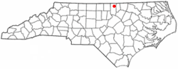
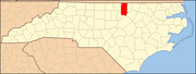
Granville County is a county located on the northern border of the U.S. state of North Carolina. As of the 2020 census, the population was 60,992. Its county seat is Oxford. The county has access to Kerr Lake and Falls Lake and is part of the Roanoke, Tar and Neuse River watersheds.

<span class="mw-page-title-main">Munfordville, Kentucky</span> City in Kentucky, United States

Munfordville is a home rule-class city in, and the county seat of, Hart County, Kentucky, United States. The population was 1,615 at the 2010 U.S. census.

<span class="mw-page-title-main">Ansonville, North Carolina</span> Town in North Carolina, United States

Ansonville is a town in Anson County, North Carolina, United States. The population was 440 at the 2020 census. The town has a total area of 1.5 square miles (3.8 km2), all land. It is located on the northern edge of Anson County, about a mile west of the Pee Dee River.

<span class="mw-page-title-main">Clarkton, North Carolina</span> Town in North Carolina, United States

Clarkton is a town in Bladen County, North Carolina, United States. The population was 837 at the 2010 census.

<span class="mw-page-title-main">Mount Pleasant, North Carolina</span> Town in North Carolina, United States

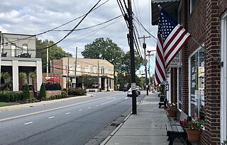
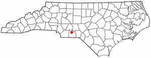
Mount Pleasant is a town located in eastern Cabarrus County, North Carolina, United States. As of the 2010 census, the town population was 1,652. The town center is located at the crossroads of Mount Pleasant Road and North Carolina Highway 73. NC Highway 49 skirts the town to the north on its way from Charlotte to Asheboro.

<span class="mw-page-title-main">Mooresboro, North Carolina</span> Town in North Carolina, United States

Mooresboro is a town in Cleveland County, North Carolina, United States. The population was 311 at the 2010 census.

<span class="mw-page-title-main">Trent Woods, North Carolina</span> Town in North Carolina, United States

Trent Woods is a town in Craven County, North Carolina, United States. The population was 4,155 in 2010. It is part of the New Bern, North Carolina Metropolitan Statistical Area.

<span class="mw-page-title-main">Macclesfield, North Carolina</span> Town in North Carolina, United States

Macclesfield is a town in Edgecombe County, North Carolina, United States. It is part of the Rocky Mount, North Carolina Metropolitan Statistical Area. The population was 471 at the 2010 census.

<span class="mw-page-title-main">Rural Hall, North Carolina</span> Town in North Carolina, United States

Rural Hall is a town in Forsyth County, North Carolina, United States. It is a part of the Piedmont Triad. The population was 3,360 at the 2020 census. The town has one public park: Covington Memorial Park.

<span class="mw-page-title-main">Butner, North Carolina</span> Town in North Carolina, United States

Butner is a town in Granville County, North Carolina, United States. The population was 8,397 as of the 2020 census. Butner was managed by the state of North Carolina from 1947 through 2007.

<span class="mw-page-title-main">Oxford, North Carolina</span> Town in North Carolina, United States

Oxford is a town in Granville County, North Carolina, United States, with a population of 8,628 as of the 2020 census. It is the county seat of Granville County.

<span class="mw-page-title-main">Enfield, North Carolina</span> Town in North Carolina, United States

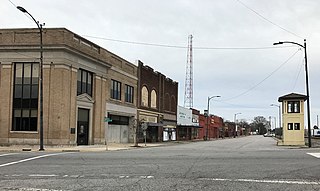
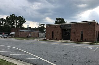
Enfield is a town in Halifax County, North Carolina, United States, and was founded in 1740. As of the 2020 census, the town's population was 1,864, which reflected a decrease of almost 27% from the population of 2,538 in 2010. It is the oldest town in Halifax County, North Carolina, and was once the world’s largest raw peanut market. Enfield is part of the Roanoke Rapids, North Carolina Micropolitan Statistical Area.

<span class="mw-page-title-main">Wrightsboro, North Carolina</span> CDP in North Carolina, United States

Wrightsboro is a census-designated place (CDP) in New Hanover County, North Carolina, United States. At the 2010 census, the population was 4,896, up from 4,496 in 2000. It is part of the Wilmington Metropolitan Statistical Area.

<span class="mw-page-title-main">Burgaw, North Carolina</span> Town in North Carolina, United States

Burgaw is a town in, and the county seat of, Pender County, North Carolina, United States. The population was 3,088 at the 2020 census.

<span class="mw-page-title-main">Winfall, North Carolina</span> Town in North Carolina, United States

Winfall is a town in Perquimans County, North Carolina, United States. The population was 554 at the 2020 census. It is part of the Elizabeth City, North Carolina Micropolitan Statistical Area.

<span class="mw-page-title-main">Columbus, North Carolina</span> Town in North Carolina, United States

Columbus is a town and the county seat of Polk County, North Carolina, United States. The population was 999 at the 2010 census.

<span class="mw-page-title-main">Salemburg, North Carolina</span> Town in North Carolina, United States

Salemburg is a town in Sampson County, North Carolina, United States. The population was 457 at the 2020 census.

<span class="mw-page-title-main">Kittrell, North Carolina</span> Town in North Carolina, United States

Kittrell is a town in Vance County, North Carolina, United States.

<span class="mw-page-title-main">Chesterfield, South Carolina</span> Town in South Carolina, United States

Chesterfield is a town in Chesterfield County, South Carolina, United States. The population was 1,472 at the 2010 census. It is the county seat of Chesterfield County. At the time of the 2010 census, Chesterfield was the least populous of all of South Carolina's county seats.

References

  1. "North Carolina Gazetteer" . Retrieved November 25, 2023.
  2. "ArcGIS REST Services Directory". United States Census Bureau. Retrieved September 20, 2022.
  3. 1 2 U.S. Geological Survey Geographic Names Information System: Stovall, North Carolina
  4. 1 2 "U.S. Census website". United States Census Bureau . Retrieved January 31, 2008.
  5. US Census Interactive Population Search Archived January 14, 2012, at the Wayback Machine , Retrieved November 11, 2011
  6. "National Register Information System". National Register of Historic Places . National Park Service. July 9, 2010.
  7. "Census of Population and Housing". Census.gov. Retrieved June 4, 2015.
  8. "US Census Fact Finder, United States Census Bureau". Archived from the original on February 16, 2020. Retrieved November 11, 2011.