
Worcestershire is a ceremonial county in the West Midlands of England. It is bordered by Shropshire, Staffordshire, and the West Midlands county to the north, Warwickshire to the east, Gloucestershire to the south, and Herefordshire to the west. The city of Worcester is the largest settlement and the county town.

The River Severn, at 220 miles (354 km) long, is the longest river in Great Britain. It is also the river with the most voluminous flow of water by far in all of England and Wales, with an average flow rate of 107 m3/s (3,800 cu ft/s) at Apperley, Gloucestershire. It rises in the Cambrian Mountains in mid Wales, at an altitude of 2,001 feet (610 m), on the Plynlimon massif, which lies close to the Ceredigion/Powys border near Llanidloes. The river then flows through Shropshire, Worcestershire and Gloucestershire. The county towns of Shrewsbury, Gloucester and Worcester lie on its course.

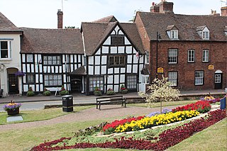
Evesham is a market town and parish in the Wychavon district of Worcestershire, in the West Midlands region of England. It is located roughly equidistant between Worcester, Cheltenham and Stratford-upon-Avon. It lies within the Vale of Evesham, an area comprising the flood plain of the River Avon, which has been renowned for market gardening. The town centre, situated within a meander of the river, is subjected regularly to flooding. The 2007 floods were the most severe in recorded history.
Upton-upon-Severn is a town and civil parish in the Malvern Hills District of Worcestershire, England. Lying on the A4104, the 2021 census recorded a population of 2,903 for the town.

Barnt Green is a village and civil parish in the Bromsgrove District of Worcestershire, England, situated 10 miles (16 km) south of Birmingham city centre, with a population at the 2011 census of 1,794.

Bredon is a village and civil parish in Wychavon district at the southern edge of Worcestershire in England. It lies on the banks of the River Avon on the lower slopes of Bredon Hill.

Henbury is a suburb of Bristol, England, approximately 5 miles (8.0 km) north west of the city centre. It was formerly a village in Gloucestershire and is now bordered by Westbury-on-Trym to the south; Brentry to the east and the Blaise Castle Estate, Blaise Hamlet and Lawrence Weston to the west. To the north lie the South Gloucestershire village of Hallen and the entertainment/retail park Cribbs Causeway.

Kempsey is a village and civil parish in the Malvern Hills District in the county of Worcestershire, England. It is bounded by the River Severn on the west, and the A38 main road runs through it and is about 3 miles (5 km) south of Worcester. The village has a long history. Its name is derived from the Saxon "Kemys' Eye", or the island of Kemys. Kemys was a Saxon chief, whose island lay between marshes and the River Severn. One of the roads in Kempsey, Lyf's Lane, is named after another Saxon chief. The village was recorded in the 11th century Domesday Book as having a value of £7.

Catshill is a village in Worcestershire about 2.5 miles north of Bromsgrove and 10 miles south-west of Birmingham. The parish of Catshill was formed around the Turnpike Road (A38) in 1844.
Feckenham is a village and civil parish in the Borough of Redditch in Worcestershire, England. It lies some 4 miles (6 km) south-west of the town of Redditch and some 11 miles (18 km) east of the city of Worcester. It had a population of 670 in the 2001 census and its immediate area is the location of notable royal manors that cover over 1,000 years of English history documented in many royal charters and Acts of Parliament. At its greatest, the historic Forest of Feckenham stretched to the River Avon in the south and to Worcester in the west. In 1389 Geoffrey Chaucer was as Clerk of Works and Keeper of the Lodge.

Whittington is a small village near Worcester close to Junction 7 of the M5 motorway, bounded by the motorway and the B4084, in the District of Wychavon. The motorway cuts through the village, most of it being on the west side but some houses were left on the east side.

St Peter's is a suburb in the civil parish of St. Peters, in the city of Worcester, in the county of Worcestershire, England. It lies south of the city centre, on the east side of the River Severn, near Junction 7 of the M5 motorway. In the 2011 census, the parish population was recorded as 5,851.

Eldersfield is a village and civil parish in the Malvern Hills district of Worcestershire, England. It had a population of 584 in 2021.

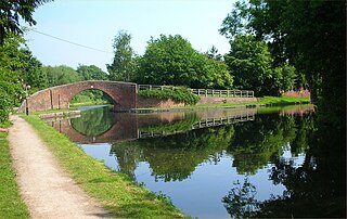
Ombersley is a village and civil parish in Wychavon district, in the county of Worcestershire, England. The parish includes the hamlet of Holt Fleet, where Telford's 1828 Holt Fleet Bridge crosses the River Severn. The 2011 census recorded a population of 2,360 for the parish.

Welland is a village and civil parish in the administrative district of Malvern Hills in the county of Worcestershire, England. It has a combined parish council with Little Malvern, with 9 of the 11 councillors. It is about 6 miles (9.7 km) from the town of Malvern, 15 miles from the city of Worcester, and 18 miles from the city of Gloucester. It is surrounded by farms and common land, and is part of the informal region referred to as The Malverns.
The Avon Ring is a canal ring which is located to the south west of Birmingham in England, and connects the major towns of Stratford-upon-Avon, Evesham, Tewkesbury, Worcester and the southern outskirts of Birmingham. It consists of stretches of four waterways, and is heavily locked, with a total of 129 locks on its route of 109 miles (175 km).

Strensham services is a motorway service station on the M5 in Worcestershire, England. It is operated by Roadchef. In August 2011, it was rated as 4 stars (southbound) and 3 stars (northbound) by quality assessors at Visit England.

Poolbrook is a village and a suburb of Malvern, Worcestershire, England, situated approximately 1.5 miles (2.4 km) southeast of Great Malvern, the town's centre, and about 0.5 miles (08 km) from the Malvern suburb of Barnards Green on the Poolbrook Road (B4208). The village comprises several shops, a traditional English pub, and a number of council and private housing estates. St Andrew's C of E parish church was built in Early English style in 1882 as a memorial to a member of the Chance Brothers glass manufacturing family. The village occupies the geographical centre of the Chase ward of Malvern Town Council.

St John the Baptist's Church is a redundant Anglican church in the village of Strensham, Worcestershire, England. It is recorded in the National Heritage List for England as a designated Grade I listed building, and is under the care of the Churches Conservation Trust. Clifton-Taylor includes the church in his list of 'best' English parish churches.
Horewell Forest was a royal forest, i. e. a royal game preserve. In the west, it bordered the river Severn, and Strensham in the south and extended to Pershore. Parts of it ceased to belong to the royal forest in 1229.


