
Nepean Highway is a major highway in Victoria, running south from St Kilda Junction in inner-southern Melbourne to Portsea, tracing close to the eastern shore of Port Phillip for the majority of its length. It is the primary road route from central Melbourne through Melbourne's southern suburbs. This name covers a few consecutive roads and is not widely known to most drivers except for its central section, as the entire allocation is still best known by the names of its constituent parts: St Kilda Road, Brighton Road and Nepean Highway proper, and Point Nepean Road. This article will deal with the entire length of the corridor for sake of completion, as well to avoid confusion between declarations.
The Bass Highway is an 87 kilometre highway in Victoria, Australia, branching off the South Gippsland Highway at the township of Lang Lang and running south, along the eastern shore of Western Port, to Anderson. The Bass Highway continues easterly to Kilcunda, Wonthaggi and Inverloch, then turns north-easterly to rejoin the South Gippsland Highway at Leongatha. It was named due to its proximity to the Bass Strait.
Melton Highway links Melbourne's outer north-western suburbs of Melton and Taylors Lakes, connecting the Western Freeway and Calder Freeway to provide a more-direct route between Ballarat and Melbourne and Essendon airports; it has a Victorian route designation of C754.
Mallee Highway is a highway in south-eastern South Australia and north-western Victoria, running mostly across the Mallee plains. It forms part of the shortest route between Adelaide and Sydney.
Hamilton Highway is a rural highway in western Victoria, Australia, linking Geelong and the town of Hamilton, through the localities of Inverleigh, Cressy, Lismore, Derrinallum, Darlington, Mortlake, and Penshurst. Glenelg Highway links Hamilton across the South Australian border to Mount Gambier, making Hamilton Highway a popular alternative Melbourne-Mount Gambier route.
Murray Valley Highway is a 663-kilometre (412 mi) state highway located in Victoria and New South Wales, Australia. The popular tourist route mostly follows the southern bank of the Murray River and effectively acts as the northernmost highway in Victoria. For all but the western end's last three kilometres, the highway is allocated route B400.
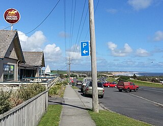
Moorooduc Highway is a 16 km highway which runs from Frankston to Tuerong and, together with the Mornington Peninsula Freeway, was part of the main route from Melbourne to the Mornington Peninsula until the completion of Peninsula Link in 2013. This name is not widely known to most drivers, as the entire allocation is still best known as by the names of its constituent parts: McMahons Road, Frankston–Flinders Road, and Moorooduc Road.

The Dandenong Valley Highway is an urban highway stretching almost 40 kilometres from Bayswater in Melbourne's eastern suburbs to Frankston in the south. This name covers many consecutive streets and is not widely known to most drivers, as the entire allocation is still best known as by the names of its constituent parts: Stud Road, Foster Street, Dandenong-Frankston Road, Dandenong Road West and Fletcher Road. This article will deal with the entire length of the corridor for sake of completion, as well to avoid confusion between declarations.

Hyland Highway is a road connecting the towns of Traralgon and Yarram in the Gippsland region of Victoria, Australia. The highway was named after Sir Herbert Hyland, a popular politician for the Country Party in the Gippsland area.
The Midland Highway is a major rural highway linking major towns in Victoria, beginning from Geelong and winding through country Victoria in a large arc through the cities of Ballarat, Bendigo and Shepparton, eventually reaching Mansfield at the foothills of the Victorian Alps.
Hopkins Highway is a short highway in south-western Victoria, Australia, serving to link the Hamilton Highway at Mortlake with the Princes Highway at the port city of Warrnambool.
Burwood Highway is a major transportation link with Melbourne's eastern suburbs. It begins in the suburb of Kooyong, Melbourne at the junction of the Monash Freeway as Toorak Road between Monash Freeway and Warrigal Road, and finishes in Belgrave, Victoria in the Dandenong Ranges. The highway is considered a major link for people who live in the Dandenong Ranges and acts as one of the major feeder roadway in the area along with Canterbury Road, Ferntree Gully Road, EastLink and Wellington Road.
Glenelg Highway is a rural highway in south-eastern Australia, linking Mount Gambier with Ballarat. Most of the highway is located within the Western part of the state of Victoria, though a short, 15 km stretch from the South Australia/Victoria state border near Ardno to Glenburnie is located in South Australia. Some maps identify the South Australian stretch as Casterton Road. Major towns along its route include Casterton, Coleraine and Hamilton.

St Georges Road is a main road in the inner northern suburbs of Melbourne, which passes through the suburbs of Fitzroy North, Northcote, Thornbury and Preston.
Western Port Highway is a highway in Victoria, Australia, linking the south-eastern fringe of suburban Melbourne to the western coast of Western Port, after which the highway is named, at the Port of Hastings nearly 30 km to the south. It runs from the end of South Gippsland Freeway at Lynbrook, firstly as a dual carriageway and later as an undivided road, to Frankston-Flinders Road at Hastings.
Warrigal Road is a major inner urban road in southeastern Melbourne, Australia. On weekdays, it is heavily trafficked as it runs through many major suburbs along its route, traversing some of Melbourne's eastern and south-eastern suburbs. These suburbs include Chadstone, Oakleigh, and Cheltenham. The Chadstone Shopping Centre can be accessed directly from Warrigal Road at its eastern entrance.

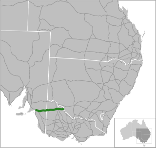
Wimmera Highway is a 345 kilometre highway that connects the towns of Marong, Victoria and Naracoorte, South Australia, through the major junctions of Sunraysia Highway, Henty Highway and Western Highway.

Docklands Highway is an urban highway stretching 12 kilometres from Brooklyn in Melbourne's inner western suburbs to the Docklands precinct, adjacent to the city. This name covers many consecutive streets and is not widely known to most drivers, as the entire allocation is still best known as by the names of its constituent parts: Francis Street, Whitehall Street, Moreland Street, Napier Street, Footscray Road, Dudley Street and Wurundjeri Way. This article will deal with the entire length of the corridor for sake of completion, as well to avoid confusion between declarations.

State Highway, also known as Lower Dandenong/Cheltenham State Highway, is an 12.5 km stretch of continuous road in the southeastern suburbs of Melbourne, Australia. These names are not widely known to most drivers, as the entire allocation is still best known as by the names of its constituent parts: Lower Dandenong Road, Cheltenham Road, and Foster Street. This article will deal with the entire length of the corridor for sake of completion, as well to avoid confusion between declarations.
Bonang Road is a rural road in south-eastern Australia, running generally south–north. It links the Gippsland region coastal town of Orbost, Victoria and the highland Monaro region town of Bombala, New South Wales.
