Sugarcreek, Ohio

Last updated

Sugarcreek, Ohio
Sugarcreek Cuckoo Clock.jpg
World's Largest Cuckoo Clock
Nickname: 
The Little Switzerland of Ohio
OHMap-doton-Sugarcreek.png
Location of Sugarcreek, Ohio
Map of Tuscarawas County Ohio Highlighting Sugarcreek Village.png
Location of Sugarcreek in Tuscarawas County, Ohio
Coordinates: 40°30′24″N81°38′20″W / 40.50667°N 81.63889°W / 40.50667; -81.63889
Country United States
State Ohio
County Tuscarawas
Township Sugar Creek
Government
  TypeVillage
Area
[1]
  Total3.80 sq mi (9.84 km2)
  Land3.80 sq mi (9.84 km2)
  Water0.00 sq mi (0.00 km2)
Elevation
[2]
1,063 ft (324 m)
Population
 (2020)
  Total2,373
  Density624.31/sq mi (241.08/km2)
Time zone UTC-5 (Eastern (EST))
  Summer (DST) UTC-4 (EDT)
ZIP code
44681
Area code 330
FIPS code 39-75210 [3]
GNIS feature ID2399927 [2]
Website http://www.villageofsugarcreek.com/

Sugarcreek is a village in Tuscarawas County, Ohio, United States. The population was 2,373 at the 2020 census. It is known as "The Little Switzerland of Ohio." [4] Located in Ohio's Amish Country, the village is part of a large regional tourism industry. [5] In the center of town stands one of the world's largest cuckoo clocks, which was previously featured on the cover of the Guinness World Records book in 1977. [6]

Contents

History

Office of The Budget The Budget Paper Office.jpg
Office of The Budget

Sugarcreek's historical beginnings were rooted in cheese production. Swiss immigrants arrived in the early 1830s and used the milk from Amish dairy farms to produce their cheese. In the 1950s they created an annual Ohio Swiss Festival; the success of early festivals as an attraction for tourists resulted in local business leaders transforming the town into a Swiss village starting in 1965. [7] :117–119 By the early 1970s the first tourist-oriented businesses were opening, and the tourism industry in Sugarcreek was centered not only around the Amish but also around a steam engine passenger train operated by the Ohio Central Railroad which ran between Sugarcreek and Baltic until 2004. Since the train stopped running, tourism in Sugarcreek has decreased. [7] :118–120 Trollinger theorizes that unlike Walnut Creek and Berlin, which support a nostalgia that reassures tourists that what they are nostalgic for still exists in America and is therefore a nostalgia of hope, the Swiss theme of Sugarcreek inspires a nostalgia for something that is forever gone— that is, a historic period in which the United States was a European immigrant based white-majority country— and so does that not reassure many people. [7] :134–135,142

Shanesville was founded in 1814 by Anthony Shane at the intersection of two Indian trails (currently Ohio State Routes 39 and 93). This village was surpassed in size and stature by Sugarcreek (then known as East Shanesville) when the railroads came in the mid-19th century. Shanesville was administratively merged with Sugarcreek in 1969, and took up the current name for the village.

Geography

Street scene in Sugarcreek Ohio - Sugarcreek 2.jpg
Street scene in Sugarcreek

Sugarcreek is located along the South Fork of Sugar Creek. [8] According to the U.S. Census Bureau, the village has a total area of 3.79 square miles (9.82 km2), all land. [9]

Demographics

Historical population
CensusPop.Note
1900 243
1910 38960.1%
1920 61858.9%
1930 89544.8%
1940 836−6.6%
1950 8896.3%
1960 98210.5%
1970 1,77180.3%
1980 1,96611.0%
1990 2,0624.9%
2000 2,1745.4%
2010 2,2202.1%
2020 2,3736.9%
Source: [10]

The village has a notable Amish community which is part of the greater Holmes County Amish settlement. Sugarcreek supports a Swiss heritage and Amish centered tourism industry, is the headquarters of The Budget weekly newspaper, the most important Amish newspaper, and has several large production facilities of the Belden Brick Company.

86.6% spoke English, 11.4% German, including Pennsylvania German, and 2.0% "Dutch", which in this case means Pennsylvania Dutch. [11]

2010 census

As of the 2010 census, [12] there were 2,220 people, 904 households, and 652 families living in the village. The population density was 585.8 inhabitants per square mile (226.2/km2). There were 967 housing units at an average density of 255.1 per square mile (98.5/km2). The racial makeup of the village was 97.8% White, 0.1% African American, 0.1% Native American, 0.1% Asian, 0.7% from other races, and 1.2% from two or more races. Hispanic or Latino of any race were 1.5% of the population.

There were 904 households, of which 28.8% had children under the age of 18 living with them, 62.2% were married couples living together, 6.2% had a female householder with no husband present, 3.8% had a male householder with no wife present, and 27.9% were non-families. 25.9% of all households were made up of individuals, and 12.9% had someone living alone who was 65 years of age or older. The average household size was 2.46 and the average family size was 2.95.

The median age in the village was 40 years. 22.3% of residents were under the age of 18; 8.5% were between the ages of 18 and 24; 25% were from 25 to 44; 26.2% were from 45 to 64; and 17.9% were 65 years of age or older. The gender makeup of the village was 49.6% male and 50.4% female.

2000 census

As of the census [3] of 2000, there were 2,174 people, 873 households, and 639 families living in the village. The population density was 572.2 inhabitants per square mile (220.9/km2). There were 923 housing units at an average density of 242.9 per square mile (93.8/km2). The racial makeup of the village was 99.13% White, 0.14% African American, 0.05% Native American, 0.46% Asian, 0.05% from other races, and 0.18% from two or more races. Hispanic or Latino of any race were 0.05% of the population.

There were 873 households, out of which 33.4% had children under the age of 18 living with them, 66.0% were married couples living together, 4.9% had a female householder with no husband present, and 26.8% were non-families. 25.5% of all households were made up of individuals, and 15.0% had someone living alone who was 65 years of age or older. The average household size was 2.49 and the average family size was 3.00.

In the village, the population was spread out, with 25.2% under the age of 18, 8.7% from 18 to 24, 27.0% from 25 to 44, 21.2% from 45 to 64, and 17.8% who were 65 years of age or older. The median age was 38 years. For every 100 females there were 95.3 males. For every 100 women age 18 and over, there were 91.0 men.

The median income for a household in the village was $36,360, and the median income for a family was $43,707. Males had a median income of $32,068 versus $19,792 for females. The per capita income for the village was $16,107. About 6.8% of families and 7.2% of the population were below the poverty line, including 9.3% of those under age 18 and 10.2% of those age 65 or over.

Education

Sugarcreek is home to the Garaway High School and Junior High. The mascot of the high school is a pirate. Sugarcreek is also home to Miller Avenue Elementary School. This is one of the four elementary schools that make up the Garaway School District. The other schools are Ragersville, Baltic, and Dundee elementaries.

Sugarcreek is served by a branch of the Tuscarawas County Public Library. [13] [14]

Related Research Articles

<span class="mw-page-title-main">Tuscarawas County, Ohio</span> County in Ohio, United States

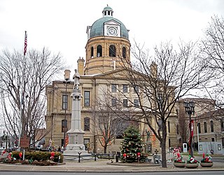
Tuscarawas County is a county located in the northeastern part of the U.S. state of Ohio. As of the 2020 census, the population was 93,263. Its county seat is New Philadelphia. Its name is a Delaware Indian word variously translated as "old town" or "open mouth". Tuscarawas County comprises the New Philadelphia–Dover, OH Micropolitan Statistical Area, which is also included in the Cleveland–Akron–Canton, OH Combined Statistical Area.

<span class="mw-page-title-main">Holmes County, Ohio</span> County in Ohio, United States

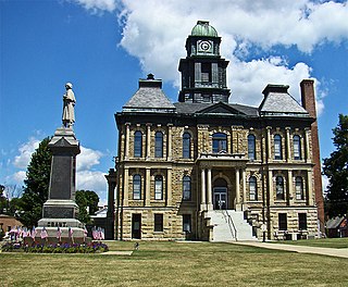
Holmes County is a county in the U.S. state of Ohio. As of the 2020 Census, the population was 44,223. Its county seat is Millersburg. The county was formed in 1824 from portions of Coshocton, Tuscarawas and Wayne counties and organized the following year. It was named after Andrew Holmes, an officer killed in the War of 1812.

<span class="mw-page-title-main">Shipshewana, Indiana</span> Town and Census designated place in Indiana, United States

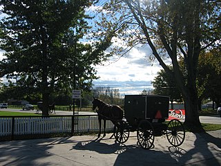
Shipshewana is a town in Newbury Township, LaGrange County, Indiana, United States. The population was 658 at the 2010 census. It is the location of the Menno-Hof Amish & Mennonite Museum, which showcases the history of the Amish and Mennonite peoples.

<span class="mw-page-title-main">Leesville, Ohio</span> Village in Ohio, United States

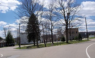
Leesville is a village in southwestern Carroll County, Ohio, United States. The population was 127 at the 2020 census. It is part of the Canton–Massillon metropolitan area.

<span class="mw-page-title-main">Middlefield, Ohio</span> Village in Ohio, United States

Middlefield is a village in Geauga County, Ohio, United States. The population was 2,748 at the 2020 census. It is part of the Cleveland metropolitan area. Middlefield is known for being the center of the world's fourth largest Amish settlement, and its significant manufacturing base, which includes Gold Key Processing, Inc., Duncan Toys and KraftMaid. Because of its central location, home of the areas' public schools and prominent business and retail presence, Middlefield village is considered the hub community for Huntsburg, Parkman, and Middlefield Townships.

<span class="mw-page-title-main">Bellbrook, Ohio</span> City in Ohio, United States

Bellbrook is a city in Greene County, Ohio, United States. The population was 7,317 at the 2020 census. It is part of the Dayton Metropolitan Statistical Area. It sits about 10.7 miles (17.2 km) southeast of Dayton.

<span class="mw-page-title-main">Bergholz, Ohio</span> Village in Ohio, United States

Bergholz is a village in northwestern Jefferson County, Ohio, United States. The population was 544 at the 2020 census. The village's name is German and translates to "mountain timber". It is part of the Weirton–Steubenville metropolitan area.

<span class="mw-page-title-main">East Sparta, Ohio</span> Village in Ohio, United States

East Sparta is a village in southern Stark County, Ohio, United States. The population was 749 at the 2020 census. It is part of the Canton–Massillon metropolitan area.

<span class="mw-page-title-main">Navarre, Ohio</span> Village in Ohio, United States

Navarre is a village in southwestern Stark County, Ohio, United States. The population was 1,846 at the 2020 census. It is part of the Canton–Massillon metropolitan area.

<span class="mw-page-title-main">Bolivar, Ohio</span> Village in Ohio, United States

Bolivar is a village in Tuscarawas County, Ohio, United States. The population was 1,000 at the 2020 census. Bolivar is also home to Fort Laurens, the only American Revolutionary War-era fort in what is now Ohio.

<span class="mw-page-title-main">Mineral City, Ohio</span> Village in Ohio, United States

Mineral City is a village in Tuscarawas County, Ohio, United States. The population was 652 at the 2020 census.

<span class="mw-page-title-main">Newcomerstown, Ohio</span> Village in Ohio, United States

Newcomerstown is a village in Tuscarawas County, Ohio, United States, 85 miles (137 km) east-northeast of Columbus. The population was 3,702 at the 2020 census.

<span class="mw-page-title-main">Port Washington, Ohio</span> Village in Ohio, United States

Port Washington is a village in Tuscarawas County, Ohio, United States. The population was 548 at the 2020 census.

<span class="mw-page-title-main">Strasburg, Ohio</span> Village in Ohio, United States

Strasburg is a village in Tuscarawas County, Ohio, United States. The population was 2,735 at the 2020 census.

<span class="mw-page-title-main">Tuscarawas, Ohio</span> Village in Ohio, United States

Tuscarawas, originally Trenton, is a village in Tuscarawas County, Ohio, United States. The population was 1,035 at the 2020 census.

<span class="mw-page-title-main">Baltic, Ohio</span> Village in Ohio, United States

Baltic is a village in Coshocton, Holmes, and Tuscarawas counties in the U.S. state of Ohio. The population was 851 at the 2020 census.

<span class="mw-page-title-main">Plain City, Ohio</span> Village in Ohio, United States

Plain City is a village in Madison and Union counties in the U.S. state of Ohio, along Big Darby Creek. The population was 4,065 at the 2020 census.

<span class="mw-page-title-main">Walnut Creek, Ohio</span> Census-designated place in Ohio, United States

Walnut Creek is an unincorporated community and census-designated place in central Walnut Creek Township, Holmes County, Ohio, United States. As of the 2020 census, it had a population of 908. Located in Ohio's Amish Country, Walnut Creek is a popular location for tourists.

<span class="mw-page-title-main">Sugar Creek Township, Wayne County, Ohio</span> Township in Ohio, United States

Sugar Creek Township is one of the sixteen townships of Wayne County, Ohio, United States. The 2020 census found 7,187 people in the township.

<span class="mw-page-title-main">Ohio Amish Country</span> Anabaptist communities in Ohio

The Ohio Amish Country, also known simply as the Amish Country, is the second-largest community of Amish in the world, with in 2023 an estimated 84,065 members according to the Young Center for Anabaptist and Pietist Studies at Elizabethtown College. Ohio's largest Amish settlement is centered around Holmes County and in 2023 included an estimated 39,525 children and adults, the second largest in the world and the highest concentration of Amish in any US county; the Amish make up half the population of Holmes County, with members of other closely related Anabaptist Christian denominations, such as the Mennonites, residing there as well. The second largest community in Ohio is centered around Geauga County.

References

  1. "ArcGIS REST Services Directory". United States Census Bureau. Retrieved September 20, 2022.
  2. 1 2 U.S. Geological Survey Geographic Names Information System: Sugarcreek, Ohio
  3. 1 2 "U.S. Census website". United States Census Bureau . Retrieved January 31, 2008.
  4. www.villageofsugarcreek.com
  5. Walle, Randi (May 31, 2018). "Explore Ohio Amish Country". Columbus Underground . Archived from the original on September 23, 2020. Retrieved August 18, 2021.
  6. Broken Trust in God’s Country, by Diana Heriques, New York Times, February 25, 2012
  7. 1 2 3 Trollinger, Susan L. (2012). Selling the Amish : the tourism of nostalgia. Baltimore: Johns Hopkins University Press. ISBN   978-1-4214-0467-7. OCLC   823654526.
  8. DeLorme (1991), Ohio Atlas & Gazetteer, Yarmouth, Maine, p. 51 ISBN   0-89933-233-1
  9. "US Gazetteer files 2010". United States Census Bureau. Archived from the original on January 25, 2012. Retrieved January 6, 2013.
  10. "Census of Population and Housing". United States Census Bureau . Retrieved December 25, 2013.
  11. "Data Center Results".
  12. "U.S. Census website". United States Census Bureau . Retrieved January 6, 2013.
  13. "Sugarcreek". Tuscarawas County Public Library. Retrieved August 11, 2014.
  14. "Sugarcreek | Tuscarawas County Public Library".