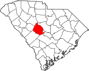
Summit, South Carolina

Last updated

Summit, South Carolina
SCMap-doton-Summit.PNG
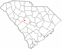
Location of Summit, South Carolina
Coordinates: 33°55′28″N81°25′23″W / 33.92444°N 81.42306°W / 33.92444; -81.42306
Country United States
State South Carolina
County Lexington
Area
[1]
  Total1.49 sq mi (3.86 km2)
  Land1.49 sq mi (3.86 km2)
  Water0.00 sq mi (0.00 km2)
Elevation
[2]
614 ft (187 m)
Population
 (2020) [3]
  Total423
  Density284.08/sq mi (109.69/km2)
Time zone UTC-5 (Eastern (EST))
  Summer (DST) UTC-4 (EDT)
ZIP code
29070
Area code(s) 803, 839
FIPS code 45-70315 [4]
GNIS feature ID1231844 [2]

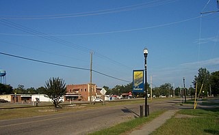
Summit is a town in Lexington County, South Carolina, United States. The population was 402 at the 2010 census. It is part of the Columbia, South Carolina Metropolitan Statistical Area.

Contents

Geography

Summit is located at 33°55′28″N81°25′23″W / 33.92444°N 81.42306°W / 33.92444; -81.42306 (33.924475, -81.423098). [5]

According to the United States Census Bureau, the town has a total area of 1.5 square miles (3.9 km2), all land.

Demographics

Historical population
CensusPop.Note
1880 57
1910 87
1920 892.3%
1930 66−25.8%
1940 7310.6%
1950 10543.8%
1960 1082.9%
1970 13020.4%
1980 17232.3%
1990 24240.7%
2000 219−9.5%
2010 40283.6%
2020 4235.2%
U.S. Decennial Census [6] [3]

As of the census [4] of 2000, there were 219 people, 92 households, and 65 families residing in the town. The population density was 145.3 inhabitants per square mile (56.1/km2). There were 103 housing units at an average density of 68.3 per square mile (26.4/km2). The racial makeup of the town was 88.13% White, 9.59% African American, 1.83% Native American, and 0.46% from two or more races. Hispanic or Latino of any race were 0.46% of the population.

There were 92 households, out of which 34.8% had children under the age of 18 living with them, 55.4% were married couples living together, 10.9% had a female householder with no husband present, and 28.3% were non-families. 23.9% of all households were made up of individuals, and 6.5% had someone living alone who was 65 years of age or older. The average household size was 2.38 and the average family size was 2.83.

In the town, the population was spread out, with 23.3% under the age of 18, 9.1% from 18 to 24, 29.2% from 25 to 44, 27.9% from 45 to 64, and 10.5% who were 65 years of age or older. The median age was 40 years. For every 100 females, there were 92.1 males. For every 100 females age 18 and over, there were 86.7 males.

The median income for a household in the town was $32,083, and the median income for a family was $35,625. Males had a median income of $27,500 versus $20,000 for females. The per capita income for the town was $15,456. About 9.6% of families and 6.3% of the population were below the poverty line, including 5.7% of those under the age of eighteen and none of those 65 or over.

Related Research Articles

<span class="mw-page-title-main">East Sandwich, Massachusetts</span> Census-designated place in Massachusetts, United States

East Sandwich is a village and census-designated place (CDP) within the town of Sandwich in Barnstable County, Massachusetts, United States. The population was 3,940 at the 2010 census.

<span class="mw-page-title-main">Ashaway, Rhode Island</span> Village and CDP in Hopkinton, Rhode Island, US

Ashaway is an unincorporated village and census-designated place (CDP) in the town of Hopkinton, Rhode Island, USA. It is a principal village of Hopkinton, along with Hope Valley, although it is the smaller of the two. The population was 1,485 at the 2010 census. The name Ashaway is derived from the American Indian name for the river that runs through the village, the Ashawague or Ashawaug, which means "land in the middle" or "land between" in the Niantic and Mohegan languages. The name "Ashawague River" appears as late as 1832 on the Findley map of Rhode Island published in Philadelphia.

<span class="mw-page-title-main">Clearwater, South Carolina</span> Census-designated place in South Carolina, United States of America

Clearwater is a census-designated place (CDP) in Aiken County, South Carolina. It lies near North Augusta, South Carolina, and is part of the Augusta, Georgia metropolitan area. Clearwater is located in historic Horse Creek Valley. The population was 4,370 at the time of the 2010 census.

<span class="mw-page-title-main">Jackson, South Carolina</span> Town in South Carolina, United States of America

Jackson is a town in Aiken County, South Carolina, United States. The population was 1,700 at the 2010 census. It is part of the Augusta, Georgia metropolitan area.
<span class="mw-page-title-main">Windsor, South Carolina</span> Town in South Carolina, United States of America

Windsor is a town in Aiken County, South Carolina, United States. The population was 121 at the 2010 census. It is part of the Augusta, Georgia metropolitan area.

Sycamore is a town in Allendale County, South Carolina, United States. The population was 180 as of the 2010 census. On April 5, 2022, the town was hit by an EF3 tornado, although it had weakened to EF1 strength by the time it moved through town and only minor damage occurred. One person was injured by this tornado south of Allendale, South Carolina.
<span class="mw-page-title-main">Elko, South Carolina</span> Town in South Carolina, United States

Elko is a town in Barnwell County, South Carolina, United States. According to the 2010 census the population was 193.

<span class="mw-page-title-main">Hilda, South Carolina</span> Town in South Carolina, United States

Hilda is a town in Barnwell County, South Carolina, United States. The population was 447 at the 2010 census..

<span class="mw-page-title-main">Kline, South Carolina</span> Town in South Carolina, United States

Kline is a town in Barnwell County, South Carolina, United States. The population was 197 at the 2010 census.
<span class="mw-page-title-main">Snelling, South Carolina</span> Town in South Carolina, United States

Snelling is a town in Barnwell County, South Carolina, United States. The population was 274 at the 2010 census.

Pine Ridge is a town in Lexington County, South Carolina, United States. The population was 2,064 at the 2010 census. It is part of the Columbia, South Carolina Metropolitan Statistical Area.

<span class="mw-page-title-main">South Congaree, South Carolina</span> Town in South Carolina, United States

South Congaree is a town in Lexington County, South Carolina, United States. The population was 2,306 at the 2010 census. It is part of the Columbia, South Carolina Metropolitan Statistical Area.

Springdale is a town in Lexington County, South Carolina, United States. The population was 2,636 at the 2010 census. It is part of the Columbia Metropolitan Statistical Area.

<span class="mw-page-title-main">Swansea, South Carolina</span> Town in South Carolina, United States

Swansea is a town in Lexington County, South Carolina, United States. The population was 827 at the 2010 census. It is part of the Columbia, South Carolina Metropolitan Statistical Area.

<span class="mw-page-title-main">Silverstreet, South Carolina</span> Town in South Carolina, United States

Silverstreet is a town in Newberry County, South Carolina, United States. The population was 162 at the 2010 census. Arguably its biggest tourist attraction is its Thunderbolt siren, tested on the 4th Saturday of every month for three minutes, and one of the only active Thunderbolts left In the state of South Carolina. With there only being five others remaining.

<span class="mw-page-title-main">Neeses, South Carolina</span> Town in South Carolina, United States

Neeses is a town in Orangeburg County, South Carolina, United States. The population was 374 at the 2010 census.
<span class="mw-page-title-main">Eastover, South Carolina</span> Town in South Carolina, United States

Eastover is a town in Richland County, South Carolina, United States. The population was 813 at the 2010 census, down from 830 in 2000. It is part of the Columbia, South Carolina, Metropolitan Statistical Area.

<span class="mw-page-title-main">Carlisle, South Carolina</span> Town in South Carolina, United States

Carlisle is a town in Union County, South Carolina, United States. The population was 436 according to the 2010 United States Census.

<span class="mw-page-title-main">Jonesville, South Carolina</span> City in South Carolina, United States

Jonesville is a town in Union County, South Carolina, United States. The population was 911 at the 2010 United States Census.

<span class="mw-page-title-main">Monetta, South Carolina</span> Town in South Carolina, United States of America

Monetta is a town in Aiken and Saluda counties, South Carolina, United States. The population was 236 at the 2010 census.
References

  1. "ArcGIS REST Services Directory". United States Census Bureau. Retrieved October 15, 2022.
  2. 1 2 U.S. Geological Survey Geographic Names Information System: Summit, South Carolina
  3. 1 2 "Census Population API". United States Census Bureau. Retrieved October 15, 2022.
  4. 1 2 "U.S. Census website". United States Census Bureau . Retrieved January 31, 2008.
  5. "US Gazetteer files: 2010, 2000, and 1990". United States Census Bureau. February 12, 2011. Retrieved April 23, 2011.
  6. "Census of Population and Housing". Census.gov. Retrieved June 4, 2015.