Swansea, South Carolina

Last updated

Swansea, South Carolina
SCMap-doton-Swansea.PNG
Location of Swansea, South Carolina
Coordinates: 33°44′14″N81°6′8″W / 33.73722°N 81.10222°W / 33.73722; -81.10222
Country United States
State South Carolina
County Lexington
Named after Swansea, Wales
Area
[1]
  Total2.14 sq mi (5.54 km2)
  Land2.09 sq mi (5.40 km2)
  Water0.05 sq mi (0.14 km2)
Elevation
[2]
358 ft (109 m)
Population
 (2020) [3]
  Total722
  Density345.95/sq mi (133.60/km2)
Time zone UTC-5 (Eastern (EST))
  Summer (DST) UTC-4 (EDT)
ZIP code
29160
Area code(s) 803, 839
FIPS code 45-70675 [4]
GNIS feature ID1231848 [2]
Website townofswansea.sc.gov

Swansea is a town in Lexington County, South Carolina, United States. The population was 827 at the 2010 census. It is part of the Columbia, South Carolina Metropolitan Statistical Area.

Contents

Geography

Swansea is located at 33°44′14″N81°06′08″W / 33.737090°N 81.102244°W / 33.737090; -81.102244 . [5] According to the United States Census Bureau, the town has a total area of 1.2 square miles (3.1 km2), of which 1.1 square miles (2.9 km2) is land and 0.1 square mile (0.1 km2) (4.20%) is water. Two streams that flow through Swansea are Fourth Creek and Bull Swamp Creek (with neighboring communities Gaston and North).

Demographics

Historical population
CensusPop.Note
1900 239
1910 523118.8%
1920 69031.9%
1930 7173.9%
1940 95032.5%
1950 762−19.8%
1960 7761.8%
1970 691−11.0%
1980 88828.5%
1990 527−40.7%
2000 5331.1%
2010 82755.2%
2020 722−12.7%
U.S. Decennial Census [6] [3]

2020 census

Swansea racial composition [7]
RaceNum.Perc.
White (non-Hispanic)34247.37%
Black or African American (non-Hispanic)30041.55%
Native American 30.42%
Asian 60.83%
Pacific Islander 20.28%
Other/Mixed 294.02%
Hispanic or Latino 405.54%

As of the 2020 United States census, there were 722 people, 370 households, and 236 families residing in the town.

2000 census

As of the census [4] of 2000, there were 533 people, 224 households, and 154 families residing in the town. The population density was 469.9 inhabitants per square mile (181.4/km2). There were 262 housing units at an average density of 231.0 per square mile (89.2/km2). The racial makeup of the town was 79.22% White, 12.15% African American, 0.75% Asian, 0.38% from other races, and 1.50% from two or more races. Hispanic or Latino of any race were 0.38% of the population.

There were 224 households, out of which 33.0% had children under the age of 18 living with them, 40.6% were married couples living together, 24.1% had a female householder with no husband present, and 31.3% were non-families. 29.5% of all households were made up of individuals, and 11.2% had someone living alone who was 65 years of age or older. The average household size was 2.38 and the average family size was 2.92.

In the town, the population was spread out, with 26.3% under the age of 18, 8.4% from 18 to 24, 26.3% from 25 to 44, 22.1% from 45 to 64, and 16.9% who were 65 years of age or older. The median age was 36 years. For every 100 females, there were 76.5 males. For every 100 females age 18 and over, there were 70.9 males.

The median income for a household in the town was $32,708, and the median income for a family was $39,306. Males had a median income of $33,000 versus $24,583 for females. The per capita income for the town was $16,007. About 14.6% of families and 14.5% of the population were below the poverty line, including 21.2% of those under age 18 and 11.0% of those age 65 or over. Swansea is the home of Poole Training Center.

Notable people

Education

Swansea has six schools. Early Childhood Center, Swansea Primary School, Sandhills Elementary School, Sandhills Middle School, Swansea High Freshman Academy, and Swansea High School.

Swansea has a public library, a branch of the Lexington County Public Library. [8]

See also

Related Research Articles

<span class="mw-page-title-main">Lexington County, South Carolina</span> County in South Carolina, United States

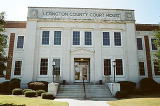
Lexington County is a county located in the U.S. state of South Carolina. As of the 2020 census, the population was 293,991. Its county seat and largest community is Lexington. The county was chartered in 1785 and was named in commemoration of Lexington, Massachusetts, the site of the Battle of Lexington in the American Revolutionary War. Lexington County is the sixth-most populous county in South Carolina by population and is part of the Columbia, SC Metropolitan Statistical Area. It is located in the Midlands region of South Carolina.

<span class="mw-page-title-main">Pinebluff, North Carolina</span> Town in North Carolina, United States

Pinebluff is a town in Moore County, North Carolina, United States. The population was 1,337 at the 2010 census.

<span class="mw-page-title-main">Southern Pines, North Carolina</span> Town in North Carolina, United States

Southern Pines is a town in Moore County, North Carolina, United States. The population was 12,334 as of the 2010 United States Census.

Ulmer is a town in Allendale County, South Carolina, United States. The population was 65 at the 2020 census.

<span class="mw-page-title-main">Hilda, South Carolina</span> Town in South Carolina, United States

Hilda is a town in Barnwell County, South Carolina, United States. The population was 447 at the 2010 census..

<span class="mw-page-title-main">Williston, South Carolina</span> Town in South Carolina, United States

Williston is a town in Barnwell County, South Carolina, United States. The population was 3,139 at the 2010 census.

<span class="mw-page-title-main">Great Falls, South Carolina</span> Town in South Carolina, United States

Great Falls is a town in Chester County, South Carolina, United States and is located fourteen miles southwest of Lancaster, South Carolina. The population was 1,951 at the 2020 census.

<span class="mw-page-title-main">Jefferson, South Carolina</span> Town in South Carolina, United States

Jefferson is a town in western Chesterfield County, South Carolina, United States at the junction of SC routes 265 and 151. Jefferson is located in the Piedmont region of South Carolina just in the edge meeting the Sandhills region. Jefferson is located 16 miles northwest of McBee, 8 miles south of Pageland, 50 miles southeast of Charlotte, North Carolina, and 70 miles north-northeast of the state capitol Columbia. As of the 2010 census, the city population was 753.

<span class="mw-page-title-main">Johnston, South Carolina</span> Town in South Carolina, United States

Johnston is a town in Edgefield County, South Carolina, United States. The population was 2,362 at the 2010 census. It is part of the Augusta, Georgia, metropolitan area. The town's official welcome sign states that it is "Peach Capital of the World".

<span class="mw-page-title-main">Pamplico, South Carolina</span> Town in South Carolina, United States

Pamplico is a town in southeastern Florence County, South Carolina, United States. The population was 1,226 at the 2010 census. It is part of the Florence Metropolitan Statistical Area.

<span class="mw-page-title-main">Gaston, South Carolina</span> Town in South Carolina, United States

Gaston is a town in Lexington County, South Carolina, United States. The population was 1,645 at the 2010 census. It is part of the Columbia, South Carolina Metropolitan Statistical Area.

<span class="mw-page-title-main">Gilbert, South Carolina</span> Town in South Carolina, United States

Gilbert is a town in Lexington County, South Carolina, United States. The population was 569 at the 2010 census. It is part of the Columbia, South Carolina Metropolitan Statistical Area.

<span class="mw-page-title-main">Oak Grove, South Carolina</span> Census-designated place in South Carolina, United States

Oak Grove is a census-designated place (CDP) in Lexington County, South Carolina, United States. The population was 10,291 at the 2010 census. It is part of the Columbia Metropolitan Statistical Area.

<span class="mw-page-title-main">Pelion, South Carolina</span> Town in South Carolina, United States

Pelion is a town in Lexington County, South Carolina, United States. The population was 674 at the 2010 census. It is part of the Columbia, South Carolina Metropolitan Statistical Area.

Pine Ridge is a town in Lexington County, South Carolina, United States. The population was 2,064 at the 2010 census. It is part of the Columbia, South Carolina Metropolitan Statistical Area.

<span class="mw-page-title-main">Red Bank, South Carolina</span> Census-designated place in South Carolina, United States

Red Bank is an unincorporated community and census-designated place (CDP) in Lexington County, South Carolina, United States. The population was 9,617 at the 2010 census, up from 8,811 at the 2000 census. It is part of the Columbia, South Carolina Metropolitan Statistical Area.

Seven Oaks is a census-designated place (CDP) in Lexington County, South Carolina, United States, 8 miles (13 km) northwest of downtown Columbia, the state capital. The population of the CDP was 15,144 at the 2010 census. It is part of the Columbia Metropolitan Statistical Area.

<span class="mw-page-title-main">South Congaree, South Carolina</span> Town in South Carolina, United States

South Congaree is a town in Lexington County, South Carolina, United States. The population was 2,306 at the 2010 census. It is part of the Columbia, South Carolina Metropolitan Statistical Area.

Springdale is a town in Lexington County, South Carolina, United States. The population was 2,636 at the 2010 census. It is part of the Columbia Metropolitan Statistical Area.

<span class="mw-page-title-main">West Columbia, South Carolina</span> City in South Carolina, United States

West Columbia, formerly Brookland, is a city and commuter town in the suburban eastern sections of Lexington County, South Carolina, United States. According to the 2010 census, the population was 14,988, and the 2019 population estimate was 17,998. West Columbia is bordered to the east by Columbia, the state capital, across the Congaree River. It is near Columbia's city center or downtown district as well as the South Carolina State House and the Congaree Vista, known locally as "the Vista." The city is bordered to the south by its sister suburb, Cayce. A small portion of the city borders the town of Lexington to the east. West Columbia is part of the greater Columbia, SC metropolitan statistical area.

References

  1. "ArcGIS REST Services Directory". United States Census Bureau. Retrieved October 15, 2022.
  2. 1 2 U.S. Geological Survey Geographic Names Information System: Swansea, South Carolina
  3. 1 2 "Census Population API". United States Census Bureau. Retrieved October 15, 2022.
  4. 1 2 "U.S. Census website". United States Census Bureau . Retrieved January 31, 2008.
  5. "US Gazetteer files: 2010, 2000, and 1990". United States Census Bureau. February 12, 2011. Retrieved April 23, 2011.
  6. "Census of Population and Housing". Census.gov. Retrieved June 4, 2015.
  7. "Explore Census Data". data.census.gov. Retrieved December 14, 2021.
  8. "Locations". Lexington County Public Library. Retrieved September 28, 2022.