Jamaica Plain is a neighborhood of 4.4 square miles (11 km2) in Boston, Massachusetts. Settled by Puritans seeking farmland to the south, it was originally part of Roxbury, Massachusetts. The community seceded from Roxbury during the formation of West Roxbury in 1851 and became part of Boston when West Roxbury was annexed in 1874. In the 19th century, Jamaica Plain became one of the first streetcar suburbs in America and home to a significant portion of Boston's Emerald Necklace of parks, designed by Frederick Law Olmsted.

Robert Treat Paine was a Boston lawyer, philanthropist, and social reformer. He is most widely known for his work as chairman of the building committee of Boston's Trinity Church in Copley Square, for his leadership of 19th century Boston philanthropists, for his summer home in Waltham, Massachusetts, and for his experiments in building housing for low- and middle-income workers.

Mission Hill is a 3⁄4 square mile, primarily residential neighborhood of Boston, bordered by Roxbury, Jamaica Plain and Fenway-Kenmore and the town of Brookline. It is home to several hospitals and universities, including Brigham and Women's Hospital and New England Baptist Hospital. Mission Hill is known for its brick row houses and triple decker homes of the late 19th century. The population was estimated at 15,883 in 2011.

Spring Hill is the name of a ridge in the central part of the city of Somerville, Massachusetts, and the residential neighborhood that sits atop it. It runs northwest to southeast, roughly bounded by Highland Avenue, Somerville Avenue, Elm Street, and Willow Avenue. Summer Street runs along the hill's crest.

The Loring–Greenough House is the last surviving 18th century residence in Sumner Hill, a historic section of Jamaica Plain, Massachusetts, a neighborhood of Boston. It is located at 12 South Street on Monument Square at the edge of Sumner Hill. It is situated on the border of two National Historic Districts.

William Hyslop Sumner was an American lawyer, soldier, and writer, and the son of Governor Increase Sumner. He graduated from Harvard College in 1799, and practiced law. He served as a general in the Massachusetts militia. Sumner wrote The History of East Boston and died in 1861.

Forest Hills is a part of the Jamaica Plain neighborhood of Boston, Massachusetts, United States. Forest Hills is characterized by hilly terrain and wooded areas within and adjacent to its borders. In general, the area slopes upward from Hyde Park Ave and downward from Walk Hill Street.
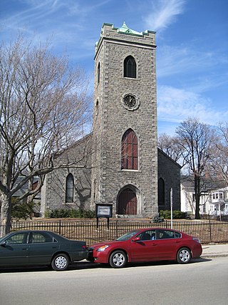
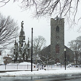
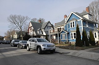
Monument Square Historic District is a predominantly residential historic district north of Monument Square in Jamaica Plain, a neighborhood of Boston, Massachusetts. The 43 acres (17 ha) district is bounded on the northwest by Pond Street, the northeast by Myrtle and Pond Streets, the southeast by Centre Street, and Holbrook and Eliot Streets to the west. This area, originally developed as country estates, was developed as a residential area in the late 19th and early 20th centuries, with its architecture reflecting a diversity of styles. Prominent non-residential buildings including the First Church of Jamaica Plain, Eliot Hall, and the Eliot School. Also included in the district is Jamaica Plain's Gothic Soldier's Monument, at the junction of South and Centre Streets.

Morton Street is a street in southern Boston, Massachusetts, United States. It extends from the southeastern end of the Arborway in Jamaica Plain to Washington Street in the Lower Mills Village of Dorchester. Most of the road is a connecting parkway, signed as part of Massachusetts Route 203, that provides access to Boston's Emerald Necklace of parks. That portion of the road was listed on the National Register of Historic Places in 2005.

The Springfield Street Historic District is a predominantly residential historic district south of the downtown area of Chicopee, Massachusetts. It encompasses a significant number of Queen Anne style houses built in the second half of the 19th century by wealthy residents of Chicopee, as well as housing for skilled workers at the nearby textile mills. It is centered where Springfield Street and Fairview Avenue meet. The district was listed on the National Register of Historic Places in 1991.
The Spring Hill Historic District is a historic district roughly bounded by Summer, Central, Atherton, and Spring Streets in the Spring Hill area of Somerville, Massachusetts. The district encompasses the city's best-preserved residential subdivision from the mid-19th century, with later infill construction in the late 19th and early 20th centuries. The district was listed on the National Register of Historic Places in 1989.

The Everett Avenue–Sheffield Road Historic District is a historic district encompassing one of the finest residential districts from the turn of the 20th century in Winchester, Massachusetts. The district is roughly triangular in shape, bounded in the north by Bacon Street, on the west by Church Street, Sheffield West, and Sheffield Road, and on the south and heast by the Upper Mystic Lake and Mystic Valley Parkway. It is characterized by winding roads, with relatively large houses on well-proportioned lots. Most of the houses were built between 1890 and 1916, and all exhibit some architectural sophistication. A significant number of properties were designed by either F. Patterson Smith or Dexter Blaikie, two local architects. The district was listed on the National Register of Historic Places in 1989.

The Edward's Plain–Dowse's Corner Historic District is a predominantly residential historic district encompassing an area where light industrial activity took place from the late 18th century to the early 20th century. It extends along North Main Street between Eliot and Everett Streets in Sherborn, Massachusetts, and was listed on the National Register of Historic Places in 1986.

The Nobility Hill Historic District is a residential historic district roughly bounded by Chestnut and Maple Streets and Cedar Avenue in Stoneham, Massachusetts. The district includes a number of high quality houses representing a cross section of fashionable housing built between 1860 and 1920. It was added to the National Register of Historic Places in 1990.

The Laurel Hill Historic District is a predominantly residential historic district south of downtown Norwich, Connecticut. The district was added to the National Register of Historic Places on October 26, 1987. It extends south from the Shetucket River along Laurel Hill Avenue, River Avenue, and Spruce Street. This area was developed as a residential district beginning in 1850, and includes a significant number of well-preserved Italianate and Gothic Revival houses.

Fort Hill is a 0.4 square mile neighborhood and historic district of Roxbury, in Boston, Massachusetts. The approximate boundaries of Fort Hill are Malcolm X Boulevard on the north, Washington Street on the southeast, and Columbus Avenue on the southwest.
The Crawford Street Historic District encompasses a collection of primarily residential apartment houses on Crawford Street between Elm Hill Avenue and Warren Street in the Roxbury neighborhood of Boston, Massachusetts, united States. The area was developed in the late 19th and early 20th centuries, and features well-preserved wood frame single and multi-family residences from that period, as well as the city's only extant Brutalist style branch library building. The district was listed on the National Register of Historic Places in 2020.

The Elm Hill Park Historic District is a historic district encompassing a small residential area in the Roxbury neighborhood of Boston, Massachusetts. It encompasses a residential development created in the early 20th century, including fine examples of Colonial Revival and Queen Anne wood-frame construction, as well as a series of brick Romanesque apartment houses. The district was listed on the National Register of Historic Places in 2021.
The Charlotte Street-Esmond Street Historic District is a historic district encompassing a residential subdivision in the Dorchester neighborhood of Boston, Massachusetts. Centered on Charlotte and Esmond Streets, the area was developed in the early 20th century following the arrival of electrified street cars on nearby Blue Hill Avenue. The district was listed on the National Register of Historic Places in 2022.


