Altamahaw is a census-designated place (CDP) in Alamance County, North Carolina, United States. It is part of the Burlington, North Carolina Metropolitan Statistical Area. As of the 2010 census it had a population of 347. The community was listed as Altamahaw-Ossipee at the 2000 census, at which time the population was 996. The town of Ossipee incorporated in 2002 and currently has a population of 543. The remainder of the territory was reassigned as the Altamahaw CDP.

Centerville is a census-designated place (CDP) in the rural northeastern corner of Franklin County, North Carolina, United States. The population was 149 at the 2020 census. It was an incorporated town from 1965 to 2017.

Lowesville is a census-designated place (CDP) in Lincoln County, North Carolina, United States. The population was 2,945 at the 2010 census, up from 1,440 in 2000.
Yadkin College is a census-designated place (CDP) in rural Davidson County, North Carolina, United States, located 9 miles (14 km) northwest of Lexington. Contrary to its name, it is not part of Yadkin County.

Pinopolis is an unincorporated community and census-designated place in Berkeley County, South Carolina, United States. As of the 2010 census it had a population of 948.

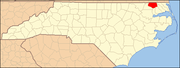
Coinjock is an unincorporated community and census-designated place (CDP) in Currituck County, North Carolina, United States. As of the 2010 census it had a population of 335. It is located on U.S. Route 158 between Barco and Grandy, about 20 miles (32 km) south of the Virginia state line, and is at mile marker 50 on the southern portion of the Albemarle and Chesapeake Canal, on the Intracoastal Waterway. Church's Island to the east of Coinjock in the Currituck Sound has a village called Waterlily, which uses the postal address of Coinjock as well. The island's name is due to a decayed church that was once a landmark of the tiny community. Coinjock is bordered by Currituck Sound to the east; the North River lies to the west. Its ZIP Code is 27923.
Advance is an unincorporated community and census-designated place (CDP) in Davie County, North Carolina, United States. It is seventy-five miles northeast of Charlotte. As of the 2010 census it had a population of 1,138. It is located along North Carolina Highway 801 just south of Bermuda Run. Advance is part of the Piedmont Triad region of North Carolina.
Hemlock is a hamlet and census-designated place (CDP) in the town of Livonia, Livingston County, New York, United States. The population was 557 as of the 2010 census.
Grandy is an unincorporated community and census-designated place (CDP) in Currituck County, North Carolina, USA. It was first listed as a CDP in the 2020 census with a population of 2,776. It is located along US 158 between the Currituck Sound and the North River.

Flintstone is an unincorporated community and census-designated place (CDP) in Allegany County, Maryland, United States. As of the 2010 census it had a population of 177. It is part of the Cumberland, MD-WV Metropolitan Statistical Area.

Moncure, founded in 1881, is a small rural unincorporated community in southeastern Chatham County, North Carolina, United States. Moncure and the neighboring community of Haywood form the Moncure census-designated place (CDP), which had a population of 711 at the 2010 census. The community is located near the confluence of the Deep and Haw rivers, which form the Cape Fear River. Moncure once served as the westernmost inland port in the state, linked to the Atlantic Ocean by steamships.

Asbury is an unincorporated community and census-designated place (CDP) located within Franklin Township in Warren County, in the U.S. state of New Jersey, that was created as part of the 2010 United States Census. As of the 2010 Census, the CDP's population was 273.
Efland is a census-designated place in Orange County, North Carolina, United States. As of the 2020 census, it had a population of 852, up from the 2010 census population of 734.
Hollister is a census-designated place and unincorporated community in Halifax County in northeastern North Carolina, United States. As of the 2010 census it had a population of 674. Hollister's ZIP code is 27844.
Piffard is a census-designated place (CDP) and hamlet in the town of York, Livingston County, New York, United States. As of the 2010 census, its population was 220. The ZIP Code is 14533.
Little Rock is an unincorporated community and census-designated place (CDP) in Dillon County, South Carolina, United States. Per the 2020 census, the population was 658.

Adams Run is an unincorporated community and census-designated place (CDP) in Charleston County, South Carolina, United States. It was first listed as a CDP in the 2020 census with a population of 421.
Cliffside is an unincorporated community and census-designated place (CDP) in southeastern Rutherford County, North Carolina, United States. Its population was 611 as of the 2010 census. Cliffside has a post office with ZIP code 28024. U.S. Route 221 Alternate and North Carolina Highway 120 pass through the community.

South Mills is an unincorporated community and census-designated place (CDP) in Camden County, North Carolina, United States. Its population was 454 as of the 2010 census. South Mills has a post office with ZIP code 27976, which opened on March 2, 1840. The community is located near U.S. Route 17, and U.S. Route 17 Business and North Carolina Highway 343, and future Interstate 87 pass through the community.
Hunt is a hamlet and census-designated place (CDP) in Livingston County, New York, United States. Its population was 78 as of the 2010 census. Hunt has a post office with ZIP code 14846.