Sungai Penuh

Last updated

Sungai Penuh
Pondok Tinggi Great Mosque.jpg
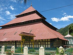
Agung Mosque, built in 1874
Flag of Sungai Penuh City.png
Lambang Kota Sungai Penuh.png
Motto: 
Sahaluk Suhak Saletuh Bedil
Lokasi Jambi Kota Sungai Penuh.svg
Location within Jambi
Indonesia Sumatra location map.svg
Red pog.svg
Sungai Penuh
Location in Sumatra and Indonesia
Indonesia location map.svg
Red pog.svg
Sungai Penuh
Sungai Penuh (Indonesia)
Coordinates: 2°3′32″S101°23′29″E / 2.05889°S 101.39139°E / -2.05889; 101.39139
Country Flag of Indonesia.svg  Indonesia
Province Flag of Jambi.svg  Jambi
Government
  MayorAhmadi Zubir
  Vice MayorAlvia Santoni
Area
  Total391.50 km2 (151.16 sq mi)
Population
 (mid 2022 estimate)
  Total99,233
  Density250/km2 (660/sq mi)
  [1]
Time zone UTC+7 (Indonesia Western Time)
Postcodes
3xxxx
Area code (+62) 748
Vehicle registration BH
Website sungaipenuhkota.go.id

Sungai Penuh (Indonesian : Kota Sungai Penuh) is a city in Indonesia, in Jambi province, on the island of Sumatra. It is an enclave within Kerinci Regency, of which it was formerly part but from which it became administratively separate on 24 June 2008. The city, whose name means "Penuh River", is also known as Siulak. It covers an area of 391.50 km2 and had a population of 82,293 at the 2010 Census [2] and 96,610 at the 2020 Census; [3] the official estimate as at mid 2022 was 99,233 (comprising 49,638 males and 49,595 females). [1]

Contents

Administrative districts

At the 2010 Census there were five districts (kecamatan), but three more were added subsequently. The eight districts currently forming the city are listed below with their areas and their populations at the 2010 Census [2] and the 2020 Census, [3] together with the official estimates as at mid 2022. [1] The table also includes the locations of the district administrative centres, the number of villages in each district (totaling 4 urban kelurahan and 65 rural desa), and its post code(s).

Kode
Wilayah
Name of
District
(kecamatan)
Area
in
km2
Pop'n
Census
2010
Pop'n
Census
2020
Pop'n
Estimate
mid 2022
Admin
centre
No.
of
villages
Post
code
15.72.04Tanah Kampung11.008,39610,79711,286Koto Panap1337121
15.72.05Kumun Debai142.008,42110,12810,450Ulu Air937111
15.72.01Sungai Penuh (district)3.3535,06710,37210,590Pasar Sungai Penuh5 (a)37111 (b)
15.72.06Pondok Tinggi90.95(c)18,51618,905Aur Duri8 (d)37111 (e)
15.72.08Sungai Bungkal
(Bungkal River)
110.95(c)11,05511,287Koto Tinggi6 (f)37111 (g)
15.72.03Hamparan Rawang12.1512,72614,89815,292Simpang Tiga Rawang1337151
15.72.02Pesisir Bukit19.4617,68311,74512,071Sungai Liuk937111
& 37152
15.72.07Koto Baru1.64(c)9,0999,352Permai Indah637152
Total city391.5082,29396,61099,23369

Notes: (a) including 2 kelurahan - the towns of Pasar Sungai Penuh and Sungai Penuh. (b) except the town of Pasar Sungai Penuh, which has a post code of 37113. (c) The 2010 population of these new districts are included with that of the existing districts from which they were cut out in 2013. (d) includes the town (kelurahan) of Pondok Tinggi. (e) except the town of Pondok Tinggi, which has a post code of 37114. (f) includes the town (kelurahan) of Dusun Baru. (g) except the town of Dusun Baru, which has a post code of 37112.

Climate

Climate data for Sungai Penuh (Depati Parbo Airport, (elevation 782 m (2,566 ft), 1991–2020 normals)
MonthJanFebMarAprMayJunJulAugSepOctNovDecYear
Mean daily maximum °C (°F)27.7
(81.9)
28.1
(82.6)
28.5
(83.3)
28.8
(83.8)
28.9
(84.0)
28.7
(83.7)
28.4
(83.1)
28.3
(82.9)
28.2
(82.8)
28.2
(82.8)
28.1
(82.6)
27.8
(82.0)
28.3
(82.9)
Daily mean °C (°F)22.3
(72.1)
22.3
(72.1)
22.4
(72.3)
22.7
(72.9)
22.9
(73.2)
22.5
(72.5)
22.2
(72.0)
22.2
(72.0)
22.2
(72.0)
22.3
(72.1)
22.4
(72.3)
22.3
(72.1)
22.4
(72.3)
Mean daily minimum °C (°F)17.5
(63.5)
17.4
(63.3)
17.5
(63.5)
18.0
(64.4)
17.8
(64.0)
17.6
(63.7)
17.1
(62.8)
17.0
(62.6)
17.3
(63.1)
17.4
(63.3)
17.8
(64.0)
17.8
(64.0)
17.5
(63.5)
Source: World Meteorological Organization [4]

See also

Related Research Articles

<span class="mw-page-title-main">Jambi</span> Province of Indonesia

Jambi is a province of Indonesia. It is located on the east coast of central Sumatra and stretches to the Barisan Mountains in the west. Its capital and largest city is also called Jambi. It is bordered by the provinces of Riau to the north, West Sumatra to the west, Bengkulu to the southwest, South Sumatra to the south, and shares a maritime border with the Riau Islands to the east and the Pacific Ocean to the east. The province has a land area of 49,026.58 km2, and a sea area of 3,274.95 km2.It's area is comparable to the European country, Slovakia. It had a population of 3,092,265 according to the 2010 census and 3,548,228 according to the 2020 census; the official estimate of population as of mid-2022 was 3,631,136.

<span class="mw-page-title-main">Depok</span> City of West Java, Indonesia

Depok (Pegon:ديڤوك) is a landlocked city in West Java province. It is located directly south of Jakarta within the Jakarta Metropolitan Area in Indonesia. It has an area of 199.91 km2. It had a population of 1,738,600 at the 2010 census and 2,056,400 at the 2020 census; the official estimate as at mid 2023 was 2,145,400, resulting in a density of 10,731.8 people per km2. Depok was created as a separate city on 20 April 1999, having previously been part of Bogor Regency. It constitutes the second most populous suburban city in Indonesia, and the tenth most populous suburban city globally.

<span class="mw-page-title-main">Pasuruan</span> City in East Java, Indonesia

Pasuruan is a city in East Java Province of Java, Indonesia. It had a population of 186,262 at the 2010 Census and 208,006 at the 2020 Census; the official estimate as at mid 2023 was 212,466.

<span class="mw-page-title-main">South Jakarta</span> Administrative city in Jakarta, Indonesia

South Jakarta, abbreviated as Jaksel, is one of the five administrative cities which form the Special Capital Region of Jakarta, Indonesia. South Jakarta is not self-governed and does not have a city council, hence it is not classified as a proper municipality. It had a population of 2,062,232 at the 2010 census and 2,226,812 at the 2020 census, and 2,244,623 as at mid 2022 according to the official estimates. It is the third most populous among the five administrative cities of Jakarta, after East Jakarta and West Jakarta. The administrative centre is at Kebayoran Baru.

<span class="mw-page-title-main">Padang Panjang</span> City in West Sumatra, Indonesia

Padang Panjang, is a city located in the cool highlands of West Sumatra, inland from the provincial capital Padang. It sits on a plateau beneath the volcanoes Mount Marapi and Mount Singgalang. It has an area of 23.0 km² and a population at the 2010 Census of 47,008 and 56,311 at the 2020 Census; the official estimate as at mid 2022 was 57,850 - comprising 29,978 males and 28,772 females. It is located at 0°27′S100°25′E.

<span class="mw-page-title-main">Tangerang Regency</span> Regency of Indonesia

Tangerang Regency is a regency of Banten Province, Indonesia. It is located in the northwest of the island of Java. The current regent is Ahmed Zaki Iskandar. Though commonly misunderstood as being a part of Jakarta, Tangerang is actually outside Jakarta City but is part of Greater Jakarta. Since 1993, the regency has lost territory as first Tangerang city was split off on 27 February 1993 and subsequently South Tangerang city was split off on 29 October 2008. The residual Regency now has an area of 1,034.54 km2 and a population of 2,834,376 at the 2010 census, growing to 3,245,619 at the 2020 census; the latest official estimate is 3,309,365, reflecting a recent slowing down in the rate of population growth since 2020. The town of Tigaraksa is the regency seat.

<span class="mw-page-title-main">Muaro Jambi Regency</span> Regency in Jambi, Indonesia

Muaro Jambi Regency is a regency of Jambi Province, Sumatra, Indonesia. It was created on 4 October 1999 by the separation of what were formerly the eastern districts of Batang Hari Regency. It surrounds the major city of Jambi, the provincial capital, and includes many of the expanding suburbs of Jambi outside the city boundaries; consequently it has experienced population growth greater than elsewhere in the province. From the 4th until the 13th century, it was the seat of the Hindu-Buddhist Melayu Kingdom. It has an area of 5,246.00 km2 and had a population of 342,952 at the 2010 census and 390,347 at the 2020 census; the official estimate as at mid 2022 is 412,830.

<span class="mw-page-title-main">Pelalawan Regency</span> Regency in Riau, Indonesia

Pelalawan is a regency (kabupaten) of Riau Province, Indonesia. It is located on the island of Sumatra. The regency was created on 4 October 1999 as a result of the division of Kampar Regency, of which it was previously the eastern 43%. It now has an area of 13,408.72 km² and had a population of 301,829 at the 2010 Census and 390,046 at the 2020 Census; the official estimate as at mid 2022 was 410,988. The administrative centre is in the town of Pangkalan Kerinci.

<span class="mw-page-title-main">Kerinci Regency</span> Regency in Jambi, Indonesia

Kerinci is a regency (kabupaten) in Jambi province, on the island of Sumatra, Indonesia. The regency has an area of 3,448.90 km2 (1,331.63 sq mi). Kerinci Regency had a population of 229,495 at the 2010 Census and 250,259 at the 2020 Census; the official estimate as at mid 2022 was 253,863. The regency largely surrounds the city of Sungai Penuh, which until its separation on 24 June 2008 was part of the regency but is now independent of it. The regency seat is at Siulak. Kerinci is located 50 km (31 mi) from Jambi City, the capital of Jambi Province. Much of the landmass of the Kerinci regency is within the boundaries of the Kerinci Seblat National Park

<span class="mw-page-title-main">Balangan Regency</span> Regency in South Kalimantan, Indonesia

Balangan Regency is one of the regencies in the Indonesian province of South Kalimantan. It was created on 25 February 2003 from what were previously the eastern districts of North Hulu Sungai Regency. It now covers an area of 1,828.51 km2, and had a population of 112,430 at the 2010 Census and 130,355 at the 2020 Census; the official estimate as of mid-2022 was 134,512, consisting of 67,958 males and 66,554 females. The capital is Paringin. Motto: "Sanggam" (Banjarese), also an acronym for "Sanggup Bagawi Gasan Masyarakat".

<span class="mw-page-title-main">South Hulu Sungai Regency</span> Regency in South Kalimantan, Indonesia

South Hulu Sungai Regency is one of the regencies (kabupaten) in South Kalimantan province, Indonesia. It had an area of 1,804.94 km2, and a population of 212,485 at the 2010 Census and 228,006 at the 2020 Census; the official estimate as at mid 2022 was 232,212. The capital of the regency is the town of Kandangan, which is famous for its culinary ketupat Kandangan.

<span class="mw-page-title-main">Central Hulu Sungai Regency</span> Regency in South Kalimantan, Indonesia

Central Hulu Sungai Regency is one of the regencies in the Indonesian province of South Kalimantan. The area is 1,770.77 km2 and the population was 243,460 at the 2010 Census and 258,721 at the 2020 Census; the official estimate as at mid 2022 was 263,061. The administrative centre is the town of Barabai.

<span class="mw-page-title-main">Tabalong Regency</span> Regency in South Kalimantan, Indonesia

Tabalong Regency is the most northerly of the regencies in the Indonesian province of South Kalimantan, on Borneo Island. It was created on 14 July 1965 by splitting off the northern districts of North Hulu Sungai Regency. It has an area of 3,553.36 km2, and had a population at the 2010 Census of 218,620 and 253,305 at the 2020 Census; the official estimate as of mid-2022 was 261,353. The administrative capital is the town of Tanjung. Motto: "Saraba Kawa" (Banjarese).

<span class="mw-page-title-main">Tanah Bumbu Regency</span> Regency in South Kalimantan, Indonesia

Tanah Bumbu is one of the regencies in the Indonesian province of South Kalimantan. It was formerly part of Kotabaru Regency, but was split off on 25 February 2003 to form a separate regency, following dissatisfaction on the Kalimantan mainland territories with administration from Laut Island. It covers an area of 4,890.3 km2 and had a population of 267,929 at the 2010 Census and 322,646 at the 2020 Census; the latest official estimate is 335,079. The regency's capital is the town of Batulicin.

<span class="mw-page-title-main">Kutai Kartanegara Regency</span> Regency in East Kalimantan, Indonesia

Kutai Kartanegara Regency is a regency of East Kalimantan Province, Indonesia. It has a land area of 27,263.10 km2 and a water area of 4,097 km2, geographically located between 1°18′40″S and 116°31′36″E. The population of the regency was 626,286 at the 2010 Census and 729,382 at the 2020 Census; the official estimate as of mid-2022 was 738,189. The town of Tenggarong is the capital of the regency.

<span class="mw-page-title-main">Padang Lawas Regency</span> Regency in North Sumatra, Indonesia

Padang Lawas is a regency in the North Sumatra province of Indonesia. It covers an area of 3,912.18 km2, and had a population of 226,807 at the 2010 Census and 261,011 at the 2020 Census; the official estimate as of mid-2023 was 275,648 - comprising 138,506 males and 137,142 females. Its administrative seat is the town of Sibuhuan. Padang Lawas Regency was created on 17 July 2007 from southeastern parts of the South Tapanuli Regency. It is the only regency in this province that borders two other provinces, West Sumatra and Riau.

<span class="mw-page-title-main">West Bangka Regency</span> Regency in Bangka Belitung Islands, Indonesia

West Bangka Regency is a regency (kabupaten) of Bangka Belitung Islands Province, Indonesia. It comprises the northwestern part of Bangka Island, together with a number of small islands off its coast. The regency covers an area of 2,820.61 km2 and had a population of 175,110 at the 2010 Census, rising to 204,612 at the 2020 census; the official estimate as at mid 2022 was 209,791 - comprising 108,102 males and 101,689 females. The town of Muntok is its regency seat.

<span class="mw-page-title-main">Empat Lawang Regency</span> Regency in South Sumatra, Indonesia

Empat Lawang Regency is a regency of South Sumatra Province, Indonesia. It was created on 2 January 2007 from what had been formerly the western districts of Lahat Regency. It covers an area of 2,256.44 km² and had a population of 221,176 at the 2010 Census and 333,622 at the 2020 Census; the official estimate as at mid 2022 was 357,673. The regency seat is at the town of Tebing Tinggi.

<span class="mw-page-title-main">North Barito Regency</span> Regency in Kalimantan, Indonesia

North Barito Regency is one of the thirteen regencies which divide the Central Kalimantan Province on the island of Kalimantan, Indonesia. It originally included much more of the northern part of the province, but on 10 April 2002 the larger northwestern part of the regency was split off to create a new Murung Raya Regency. Muara Teweh is the capital of North Barito Regency, which covers an area of 10,152.25 km2. The population of North Barito Regency was 121,573 at the 2010 Census and 154,812 at the 2020 Census; the official estimate as at mid 2022 was 160,235.

<span class="mw-page-title-main">Kubu Raya Regency</span> Regency in West Kalimantan, Indonesia

Kubu Raya Regency or Great Kubu Regency is a regency of West Kalimantan, Indonesia. It was created on 17 July 2007 from the (larger) central and southern part of what was at that time the Pontianak Regency. It covers an area of 8,492.10 km2, and it had a population of 500,970 at the 2010 Census and 609,392 at the 2020 Census; the official estimate as at mid 2022 was 622,217. The principal town lies at Sungai Raya, directly adjacent to the City of Pontianak. Despite its close location to Pontianak, the regional capital and economic centre of the West Kalimantan Province, Kubu Raya highly lacks sufficient infrastructure development, which has caused general suspicions regarding the performance of its local government.

References

  1. 1 2 3 Badan Pusat Statistik, Jakarta, 2023, Kota Sungai Penuh Dalam Angka 2023 (Katalog-BPS 1102001.1572)
  2. 1 2 Biro Pusat Statistik, Jakarta, 2011.
  3. 1 2 Badan Pusat Statistik, Jakarta, 2021.
  4. "World Meteorological Organization Climate Normals for 1991–2020". World Meteorological Organization. Retrieved 19 October 2023.
  1. (in Indonesian) https://web.archive.org/web/20101013091507/http://www.bps.go.id/aboutus.php?hasilSP2010=1