
The Mass Rapid Transit system, locally known by the initialism MRT, is a rapid transit system in Singapore and the island country's principal mode of railway transportation. The system commenced operations in November 1987 after two decades of planning with an initial 6 km (3.7 mi) stretch consisting of five stations. The network has since grown to span the length and breadth of the country's main island – with the exception of the forested core and the rural northwestern region – in accordance with Singapore's aim of developing a comprehensive rail network as the backbone of the country's public transportation system, averaging a daily ridership of 3.4 million in 2019.
The North–South Line (NSL) is a high-capacity Mass Rapid Transit (MRT) line in Singapore, operated by SMRT Corporation. Coloured red on the Singapore rail map, the line is 45 kilometres (28 mi) long and serves 27 stations, 11 of which, between the Bishan and Marina South Pier stations, are underground. It runs from Jurong East station, located in Western Singapore, to Marina South Pier station in the Central Area, via Woodlands station in northern Singapore. The line operates for almost 20 hours a day, with headways of up to 1 to 2 minutes during peak hours and 5 to 8 minutes during off-peak hours. All the trains on the North–South Line run with a six-car formation.

Tampines MRT station is a Mass Rapid Transit (MRT) interchange station on the East West (EWL) and Downtown (DTL) lines in Tampines, Singapore. Located in the heart of the Tampines town centre next to Tampines Avenue 4, Tampines Central 4 and Tampines Central 5, it is in close proximity to the Tampines and Tampines Concourse bus interchanges. The station also serves the surrounding retail developments of Tampines Mall, Tampines One and Century Square.

Expo MRT station is a Mass Rapid Transit (MRT) interchange station on the East West line (EWL) and Downtown line (DTL) in the Tampines planning area, Singapore. The station lies between Changi City Point and the Singapore Expo, located along Changi South Avenue 1 at the junction of Expo Drive.

Newton MRT station is an underground Mass Rapid Transit (MRT) interchange station on the North South (NSL) and Downtown (DTL) lines. It is located in Newton, Singapore, at the junction of Scotts Road and Bukit Timah Road near Newton Circus. The station serves the offices and condominiums around Newton Circus including Goldbell Towers and Scotts Highpark, and it is within walking distance to the Newton Food Centre.

Promenade MRT station is an underground Mass Rapid Transit (MRT) interchange station on the Downtown (DTL) and Circle (CCL) lines in Downtown Core, Singapore. Located underneath Temasek Avenue and adjacent to Millenia Tower, the station serves several key attractions and locations such as Suntec City and the Marina Promenade, which the station is named after. The station is at the junction of the Dhoby Ghaut and Marina Bay branches of the CCL.

Sembawang MRT station is an elevated Mass Rapid Transit (MRT) station on the North–south line (NSL). Located in Sembawang, Singapore along Sembawang Road, the station is close to the Sun Plaza shopping centre and Sembawang Bus Interchange. The station is operated by SMRT Trains.

Kranji MRT station is an elevated Mass Rapid Transit (MRT) station on the North South line (NSL). Situated in Sungei Kadut, Singapore along Woodlands Road, it serves the Singapore Turf Club and the Woodlands Wafer Fabrication Park. The station is operated by SMRT Trains.

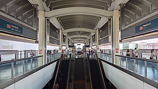
Woodlands MRT station is a Mass Rapid Transit (MRT) interchange station on the North–South (NSL) and Thomson–East Coast (TEL) lines in Singapore. Located in Woodlands, the MRT station was the first to feature an underground bus interchange underneath the NSL station. The station is also integrated with surrounding developments, including Causeway Point and the Woodlands Civic Centre.
Admiralty MRT station is an elevated Mass Rapid Transit (MRT) station on the North South line (NSL) in Woodlands, Singapore. Located along Woodlands Avenue 7 near the junctions of Woodlands Avenue 6 and Woodlands Drive 71, the station primarily serves the residential precincts in the eastern part of Woodlands New Town. This station took its name from a former Royal Navy base located on the northern coast of Singapore.

Khatib MRT station is an above-ground Mass Rapid Transit (MRT) station on the North South line (NSL) located in Khatib, Singapore, a subzone in Yishun planning area.

Bayfront MRT station is an underground Mass Rapid Transit (MRT) interchange station on the Downtown line (DTL) and Circle line (CCL). Located in the Downtown Core of Singapore, the station is underneath Bayfront Avenue and serves the main tourist attractions of Marina Bay Sands and Gardens by the Bay.

The Downtown Line (DTL) is a medium-capacity Mass Rapid Transit (MRT) line in Singapore operated by SBS Transit. It runs from Bukit Panjang station in the north-west to Expo station in the east via the Central Area. Coloured blue on the rail map, the line serves 34 stations, all of which are underground. The DTL is the fifth MRT line on the network to be opened and the third line to be entirely underground. It is the second MRT line to be operated by SBS Transit, after the North East Line. The line also serves as an alternative to the East-West MRT Line running parallel from Bugis to Expo MRT Station.

The Thomson–East Coast Line (TEL) is a high-capacity Mass Rapid Transit (MRT) line in Singapore. Coloured brown on the rail map, it is fully underground. When fully completed, the sixth line on the country's MRT network will serve 32 stations over 43 kilometres (27 mi) in length, becoming one of the world's longest driverless rapid transit lines. It runs along a combined north–south and east–west corridor, starting in the north at Woodlands town, passing through Upper Thomson and the towns of Ang Mo Kio and Bishan, heading south to the city-centre at Orchard Road and Marina Bay, subsequently heading eastwards along the eastern coast of the country through Kallang, Marine Parade and southern Bedok before ending at Upper East Coast.

Bukit Panjang MRT/LRT station is a Mass Rapid Transit (MRT) and Light Rail Transit (LRT) interchange station on the Downtown line (DTL) and the Bukit Panjang LRT line (BPLRT) in Singapore. Located in the namesake estate of Bukit Panjang, the station is at the junction of Upper Bukit Timah Road and Petir Road. The station serves the commercial buildings of Bukit Panjang Plaza, Hillion Mall and Junction 10. It forms a part of the Bukit Panjang Integrated Transport Hub (BPITH), which also contains a bus interchange.

The SMRT Active Route Map Information System is a rail travel information system developed in house by communications engineers from SMRT Corporation for its North South Line and East West Line (NSEWL) trains in Singapore. This system was officially announced on 7 November 2008 and was first installed on board a C151 trainset 053/054 for a 2-month trial. This was later extended to other trains from February 2009.

Sungei Kadut is an industrial estate and planning area located in the North Region of Singapore. It is bounded by Bukit Panjang and Choa Chu Kang to the south, Mandai to the east, as well as Lim Chu Kang and the Western Water Catchment to the west. Its northern boundary is defined by the Straits of Johor. Sungei Kadut is divided into five subzones, namely Kranji, Turf Club, Gali Batu, Pang Sua and Reservoir View.

Jalan Besar MRT station is an underground Mass Rapid Transit station on the Downtown Line in Rochor, Singapore. The station is located under Jalan Besar, at the junction with Weld Road, hence its name.
The Cross Island Line (CRL) is a high capacity Mass Rapid Transit (MRT) line under development in Singapore. It will run in an east–west direction from Changi to Jurong Industrial Estate via Loyang, Pasir Ris, Hougang, Serangoon North, Ang Mo Kio, Sin Ming, Bukit Timah, Clementi and West Coast. From Pasir Ris, the line will branch off to Punggol. The 58-kilometre (36 mi) line will replace the East West Line as the longest line on the MRT network upon its complete opening by the 2040s, serving about 27 stations.

Sungei Bedok MRT station is a future underground Mass Rapid Transit interchange and terminal station on the Downtown line and Thomson–East Coast line in Bedok planning area, Singapore. The station is being built east of where Upper East Coast Road becomes Bedok Road, and will serve residents of the Eastwood estate. Nearby facilities include the Bedok Food Centre, Eastwood Centre and the Laguna National Golf & Country Club.
