
Lincoln County is a county located in the U.S. state of Colorado. As of the 2010 census, the population was 5,467. The county seat is Hugo. The county obtains its name in memory of President Abraham Lincoln.

Boulder County is a county located in the U.S. state of Colorado of the United States. As of the 2010 census, the population was 294,567. The most populous municipality in the county and the county seat is Boulder.

The Colorado River is an approximately 862-mile (1,387 km) long river in the U.S. state of Texas. It is the 18th longest river in the United States and the longest river with both its source and its mouth within Texas.

The Lost Dutchman's Gold Mine is, according to legend, a rich gold mine hidden in the southwestern United States. The location is generally believed to be in the Superstition Mountains, near Apache Junction, east of Phoenix, Arizona. There have been many stories about how to find the mine, and each year people search for the mine. Some have died on the search.

"Superstition" is a song by American singer-songwriter Stevie Wonder. It was released on October 24, 1972, as the lead single from his fifteenth studio album, Talking Book (1972), by Tamla. The lyrics describe popular superstitions and their negative effects.
Indio Hills Palms Park Property and the Coachella Valley Preserve, located in the Indio Hills, contain the 1,000 Palms Oasis and are a protected area in the Coachella Valley, located east of Palm Springs near Palm Desert, California. The Coachella Valley National Wildlife Refuge is contained within the Coachella Valley Preserve, and all are in the Colorado Desert section of the Sonoran Desert and adjacent to the Lower Colorado River Valley region.

The Superstition Mountains is a range of mountains in Arizona located to the east of the Phoenix metropolitan area. They are anchored by Superstition Mountain, a large mountain that is a popular recreation destination for residents of the Phoenix, Arizona, area.

The San Jacinto Fault Zone (SJFZ) is a major strike-slip fault zone that runs through San Bernardino, Riverside, San Diego, and Imperial Counties in Southern California. The SJFZ is a component of the larger San Andreas transform system and is considered to be the most seismically active fault zone in the area. Together they relieve the majority of the stress between the Pacific and North American tectonic plates.

The Cochetopa Hills are a ridge of uplands on the Continental Divide in Saguache County, southern Colorado, United States.
In folkloristics, folk belief or folk-belief is a broad genre of folklore that is often expressed in narratives, customs, rituals, foodways, proverbs, and rhymes. It also includes a wide variety of behaviors, expressions, and beliefs. Examples of concepts included in this genre are magic, popular belief, folk religion, planting signs, hoodoo, conjuration, charms, root work, taboos, old wives' tales, omens, portents, the supernatural and folk medicine.
The Arkansas Hills are a mountain range in Central Colorado located between the upper Arkansas River Valley and the upper South Platte River Valley. This landmass is a continuation of the ridge known as the Mosquito Range north of Trout Creek Pass. The range continues for roughly 60 miles south-southwest from Trout Creek Pass to the town of Texas Creek. Few perennial streams flow out of the Arkansas Hills, as the area is arid. The range is in the rain shadow of the much higher Sawatch to the west across the Arkansas River Valley. The City of Salida, Colorado is the most notable municipality near the Arkansas Hills. To the south is the town of Cotopaxi, Colorado. To the east is the town of Guffey, Colorado. The highest points in the Arkansas Hills tend to be between 11,000 and 12,000 feet elevation.
A superstition is a belief or practice typically resulting from ignorance, a misunderstanding of science or causality, a belief in fate or magic, perceived supernatural influence, or fear of that which is unknown. It is commonly applied to beliefs and practices surrounding luck, prophecy, and certain spiritual beings, particularly the belief that future events can be foretold by specific (apparently) unrelated prior events.
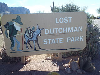
Lost Dutchman State Park is a 320-acre (129 ha) state park located near the Superstition Mountains in central Arizona, USA, and named after the Lost Dutchman's Gold Mine, a famous gold mine legendary among the tales of the Old West. It is accessible about 40 miles (64 km) east of Phoenix via U.S. Highway 60, the Superstition Freeway.

The Arizona/New Mexico Mountains ecoregion is a Level III ecoregion designated by the United States Environmental Protection Agency (EPA) in the U.S. states of Arizona and New Mexico.
There is a superstition that bad luck will come to a person who places shoes on a table.

Janet Petra Bonnema was an American civil engineer and women's rights activist. She was hired as an engineering technician for the Eisenhower Tunnel construction project in Colorado in 1970, but was barred from performing her work inside the tunnel due to the prevailing superstition that women who went underground in tunnels or mines brought bad luck, endangering the male workers. In 1972 she filed a $100,000 class action lawsuit against the Colorado Department of Highways for sexual discrimination. The state settled the case out of court and she was allowed to enter the tunnel, although she dressed inconspicuously. She became a symbol for equal rights in the workplace. She was posthumously inducted into the Colorado Women's Hall of Fame in 2012.

Lauren Opal Boebert is an American politician, businesswoman, and gun-rights activist, serving as the U.S. Representative for Colorado's 3rd congressional district since 2021.

The 1987 Superstition Hills earthquakes were a pair of earthquakes Mw 6.2 and 6.6 that rattled the Imperial Valley of California. The earthquakes caused damage to places in California and Mexico, and was felt as far as Las Vegas and Phoenix. Both main shocks were larger than the deadly earthquake that struck Los Angeles on October 1, which was a magnitude 5.9.

The 1968 Borrego Mountain earthquake occurred in the evening hours of April 8, near the small unincorporated community of Ocotillo Wells in San Diego County. The moment magnitude 6.6 earthquake reached IX (Violent) on the Mercalli intensity scale, causing some damage in the Imperial Valley, although no injuries or deaths had been reported. Shaking from this earthquake was felt over a wide area, even being reported in Las Vegas, Nevada, and parts of Arizona. This was the largest earthquake in Southern California since the 1952 Kern County earthquake 16 years prior.

The San Luis Hills are a group of small mountain ranges in Conejos and Costilla counties in the San Luis Valley in southern Colorado. The individual mountain ranges that make up the San Luis Hills include the Fairy Hills, the Brownie Hills, the Piñon Hills, and the South Piñon Hills. The San Luis Hills' highest point is Flat Top, elevation 9,206 feet

