Surrency, Georgia

Last updated

Surrency, Georgia
Appling County Georgia Incorporated and Unincorporated areas Surrency Highlighted.svg
Location in Appling County and the state of Georgia
Coordinates: 31°43′27″N82°11′55″W / 31.72417°N 82.19861°W / 31.72417; -82.19861
Country United States
State Georgia
County Appling
Area
[1]
  Total0.78 sq mi (2.01 km2)
  Land0.77 sq mi (2.00 km2)
  Water0.00 sq mi (0.00 km2)
Elevation
184 ft (56 m)
Population
 (2020)
  Total194
  Density250.97/sq mi (96.91/km2)
Time zone UTC-5 (Eastern (EST))
  Summer (DST) UTC-4 (EDT)
ZIP code
31563
Area code 912
FIPS code 13-74852 [2]
GNIS feature ID0333168 [3]

Surrency is a town in Appling County, Georgia, United States. The population was 194 in 2020.

Contents

History

The Georgia General Assembly incorporated Surrency as a town in 1911. [4] The community was named after Millard Surrency, a pioneer citizen. [5]

Geography

Surrency is located at 31°43′27″N82°11′55″W / 31.724156°N 82.198686°W / 31.724156; -82.198686 . [6] According to the United States Census Bureau, the town has a total area of 0.8 square mile (2.0 km2), all land.

Climate

Climate data for Surrency, Georgia, 1991–2020 normals, extremes 19562003
MonthJanFebMarAprMayJunJulAugSepOctNovDecYear
Record high °F (°C)83
(28)
88
(31)
90
(32)
96
(36)
98
(37)
106
(41)
105
(41)
105
(41)
100
(38)
94
(34)
88
(31)
83
(28)
106
(41)
Mean daily maximum °F (°C)63.0
(17.2)
66.8
(19.3)
73.2
(22.9)
80.3
(26.8)
86.3
(30.2)
91.2
(32.9)
92.0
(33.3)
90.4
(32.4)
87.8
(31.0)
80.6
(27.0)
71.4
(21.9)
65.5
(18.6)
79.0
(26.1)
Daily mean °F (°C)51.0
(10.6)
53.5
(11.9)
59.5
(15.3)
66.1
(18.9)
72.6
(22.6)
79.4
(26.3)
81.0
(27.2)
79.7
(26.5)
76.6
(24.8)
67.8
(19.9)
58.2
(14.6)
52.8
(11.6)
66.5
(19.2)
Mean daily minimum °F (°C)39.0
(3.9)
40.3
(4.6)
45.8
(7.7)
51.9
(11.1)
58.8
(14.9)
67.6
(19.8)
70.0
(21.1)
68.9
(20.5)
65.4
(18.6)
55.0
(12.8)
45.0
(7.2)
40.2
(4.6)
54.0
(12.2)
Record low °F (°C)1
(−17)
12
(−11)
16
(−9)
29
(−2)
39
(4)
48
(9)
55
(13)
56
(13)
38
(3)
24
(−4)
19
(−7)
3
(−16)
1
(−17)
Average precipitation inches (mm)3.57
(91)
3.44
(87)
3.88
(99)
2.63
(67)
3.23
(82)
5.29
(134)
4.98
(126)
5.62
(143)
4.25
(108)
2.70
(69)
2.25
(57)
3.82
(97)
45.66
(1,160)
Average precipitation days (≥ 0.01 in)9.87.38.86.26.711.811.410.98.85.95.97.8101.3
Source 1: NOAA [7]
Source 2: XMACIS2 [8]

Demographics

Historical population
CensusPop.Note
1910 259
1920 43367.2%
1930 4452.8%
1940 431−3.1%
1950 295−31.6%
1960 3125.8%
1970 35212.8%
1980 3684.5%
1990 253−31.2%
2000 237−6.3%
2010 201−15.2%
2020 194−3.5%
U.S. Decennial Census [9]

As of the census [2] of 2000, there were 237 people, 98 households, and 69 families residing in the town. By 2020, its population declined to 194.

Related Research Articles

<span class="mw-page-title-main">Nahunta, Georgia</span> City in Georgia, United States

Nahunta is a city and the county seat in Brantley County, Georgia, United States. It is part of the Brunswick, Georgia metropolitan statistical area. The population was 1,013 at the 2020 census. The city is an important crossroad which is intersected by U.S. Route 82 and U.S. Route 301 in its downtown area.

<span class="mw-page-title-main">Vidette, Georgia</span> City in Georgia, United States

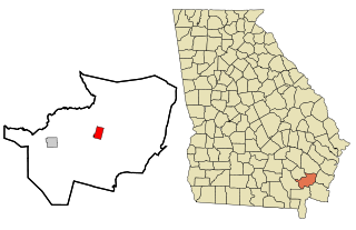
Vidette is a city in Burke County, Georgia, United States. The population was 103 in 2020. It is part of the Augusta, Georgia metropolitan area.

<span class="mw-page-title-main">Woodbine, Georgia</span> City in Georgia, United States

Woodbine is a city in and the county seat of Camden County, Georgia, United States, an original county established when the state constitution was adopted in 1777. The population was 1,062 in 2020.

<span class="mw-page-title-main">Metter, Georgia</span> City in Georgia, United States

Metter is a city and the county seat of Candler County, Georgia, United States. The population was 4,130 at the 2010 census. In 2020, its population was 4,004.

<span class="mw-page-title-main">Hartwell, Georgia</span> City in Georgia, United States

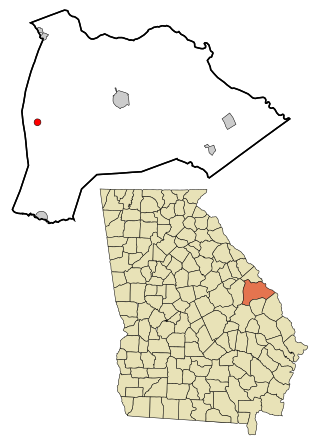
Hartwell is a city in Hart County, Georgia, United States. The population was 4,469 at the 2010 census. The city is the county seat of Hart County.

<span class="mw-page-title-main">Denton, Georgia</span> City in Georgia, United States

Denton is a city in Jeff Davis County, Georgia, United States. The population was 189 in 2020.

<span class="mw-page-title-main">Kite, Georgia</span> City in Georgia, United States

Kite is a city in Johnson County, Georgia, United States, along the Little Ohoopee River. The population was 160 in 2020.

<span class="mw-page-title-main">Rentz, Georgia</span> Town in Georgia, United States

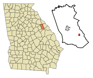
Rentz is a city in Laurens County, Georgia, United States. The population was 312 in 2020.

<span class="mw-page-title-main">Dearing, Georgia</span> Town in Georgia, United States

Dearing is a town in McDuffie County, Georgia, United States. The population was 529 at the 2020 census. It is part of the Augusta metropolitan area.

<span class="mw-page-title-main">Experiment, Georgia</span> Place in Georgia, United States

Experiment is an unincorporated community and census-designated place (CDP) in Spalding County, Georgia, United States. The population was 3,233 at the 2000 census.

<span class="mw-page-title-main">Cobbtown, Georgia</span> City in Georgia, United States

Cobbtown is a city in Tattnall County, Georgia, United States. The population was 341 in 2020.

<span class="mw-page-title-main">Collins, Georgia</span> City in Georgia, United States

Collins is a city in Tattnall County, Georgia, United States. The population was 540 in 2020.

<span class="mw-page-title-main">Scotland, Georgia</span> City in Georgia, United States

Scotland is a city in Telfair and Wheeler counties in the U.S. state of Georgia. As of 2020, its population was 173.

<span class="mw-page-title-main">Camak, Georgia</span> Town in Georgia, United States

Camak is a town in Warren County, Georgia, United States. The town is located just off Interstate 20 between Atlanta and Augusta. The population was 141 in 2020.

<span class="mw-page-title-main">Warrenton, Georgia</span> City in Georgia, United States

Warrenton is a city in Warren County, Georgia, United States. The population was 1,744 in 2020. The city is the county seat of Warren County.

<span class="mw-page-title-main">Deepstep, Georgia</span> Town in Georgia, United States

Deepstep is a town in Washington County, Georgia, United States. The population was 117 in 2020.

<span class="mw-page-title-main">Harrison, Georgia</span> Town in Georgia, United States

Harrison is a town in Washington County, Georgia, United States. The population was 339 in 2020.

<span class="mw-page-title-main">Oconee, Georgia</span> City in Georgia, United States

Oconee is a city in Washington County, Georgia, United States. The population was 197 in 2020.

<span class="mw-page-title-main">Riddleville, Georgia</span> Town in Georgia, United States

Riddleville is a town in Washington County, Georgia, United States. The population was 80 in 2020.

<span class="mw-page-title-main">Odum, Georgia</span> Town in Georgia, United States

Odum is a town in Wayne County, Georgia, United States. The population was 463 at the 2020 census.

References

  1. "2020 U.S. Gazetteer Files". United States Census Bureau. Retrieved December 18, 2021.
  2. 1 2 "U.S. Census website". United States Census Bureau . Retrieved January 31, 2008.
  3. "US Board on Geographic Names". United States Geological Survey. October 25, 2007. Retrieved January 31, 2008.
  4. Acts and Resolutions of the General Assembly. 1911. p. 1577.
  5. Krakow, Kenneth K. (1975). Georgia Place-Names: Their History and Origins (PDF). Macon, GA: Winship Press. p. 216. ISBN   0-915430-00-2.
  6. "US Gazetteer files: 2010, 2000, and 1990". United States Census Bureau. February 12, 2011. Retrieved April 23, 2011.
  7. "U.S. Climate Normals Quick Access – Station: Surrency, GA". National Oceanic and Atmospheric Administration. Retrieved May 11, 2023.
  8. "xmACIS2". National Oceanic and Atmospheric Administration. Retrieved May 11, 2023.
  9. "Census of Population and Housing". Census.gov. Retrieved June 4, 2015.