Sutton-at-Hone and Hawley

Last updated

Sutton-at-Hone and Hawley
Hawleysnow.JPG
Picture taken in the snow at the top of Shirehall Road, Hawley
Kent UK location map.svg
Red pog.svg
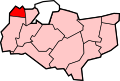
Sutton-at-Hone and Hawley
Location within Kent
Population4,230 (2011 census)
Civil parish
  • Sutton-at-Hone and Hawley
District
Shire county
Region
Country England
Sovereign state United Kingdom
List of places
UK
England
Kent

51°25′N0°14′E / 51.417°N 0.233°E / 51.417; 0.233

Contents

Sutton-at-Hone and Hawley

Sutton-at-Hone and Hawley is a civil parish within the Borough of Dartford in Kent, England. It lies to the south of the urban part of the Borough, and consists of the two settlements named, both to the west of the River Darent, one of the parish boundaries. The M25 motorway divides them. It has a population of 4,133, [1] increasing to 4,230 at the 2011 Census. [2]

History of the parish

In former times, when Kent was administered through areas known as lathes, Sutton-at-Hone was a half-lathe. It covered an area well in excess of Dartford Borough as it is today. The half-lathe embraced a number of towns and villages including Dartford (Darentford) and Hawley. 1894 saw the formation of the Parish Council of Sutton-at-Hone under the Local Government Act of that year. At that time the Council's area included Sutton-at-Hone, Hawley, Swanley Junction, Swanley Village, Hextable and Crockenhill. In 1955 many parish boundaries were changed dramatically and the Parish was reduced to just Sutton-at-Hone and Hawley. In the late 1970s the parish was renamed Sutton-at-Hone and Hawley Parish Council to reflect its specific administration area see

St John's Jerusalem

Within the parish is the one-time Commandery of the Knights Hospitallers of the Order of St John of Jerusalem. Now in the hands of the National Trust, the garden and 13th century chapel are open to the public.

Farningham Road railway station is also located within the parish.

Notes and references

  1. Census 2001
  2. "Civil Parish population 2011". Neighbourhood Statistics. Office for National Statistics. Retrieved 11 September 2016.

Related Research Articles

<span class="mw-page-title-main">Borough of Dartford</span> Borough & Non-metropolitan district in England

The Borough of Dartford is a local government district in the north-west of the county of Kent, England. Its council is based in the town of Dartford. It is part of the contiguous London urban area. It borders the borough of Gravesham to the east, Sevenoaks District to the south, the London Borough of Bexley to the west, and the Thurrock unitary authority in Essex to the north, across the River Thames. The borough was formed on 1 April 1974 by the merger of the Municipal Borough of Dartford, the Swanscombe Urban District, and part of the Dartford Rural District. According to the 2011 Census, its population was 97,365, increasing to 116,800 in the 2021 census.

<span class="mw-page-title-main">Sevenoaks District</span> Non-metropolitan district in England

Sevenoaks is a local government district in west Kent, England. Its council is based in the town of Sevenoaks.

<span class="mw-page-title-main">Lathe (county subdivision)</span> Division of Kent, England

A lathe formed an administrative country subdivision of the county of Kent, England, from the Anglo-Saxon period, until it fell out of general practical use in the early twentieth century.

Stone is a village in the Borough of Dartford in Kent, England. It is located 2.5 miles east of Dartford.

<span class="mw-page-title-main">Swanley</span> Town in Kent, England

Swanley is a town and civil parish in the Sevenoaks District of Kent, England, 16 miles (26 km) southeast of central London, adjacent to the Greater London boundary and within the M25 motorway periphery. The population at the 2021 census was 17,826.

<span class="mw-page-title-main">Sevenoaks (UK Parliament constituency)</span> Parliamentary constituency in the United Kingdom, 1885 onwards

Sevenoaks is a constituency in Kent represented in the House of Commons of the UK Parliament since 2019 by Laura Trott, a Conservative who has served as Chief Secretary to the Treasury since 13 November 2023. The seat was previously held by Michael Fallon, who served as Secretary of State for Defence from 2014 to 2017.

<span class="mw-page-title-main">Dartford (UK Parliament constituency)</span> UK Parliament constituency since 1885

Dartford is a constituency in Kent represented in the House of Commons of the UK Parliament since 2010 by Gareth Johnson of the Conservative Party. It is the longest bellwether constituency in the country: the party of the winning candidate has gone on to form the government at every UK general election since 1964. Candidates for the largest two parties nationally have polled first and second since 1923 in Dartford.

<span class="mw-page-title-main">Hextable</span> Human settlement in England

Hextable is a village and civil parish in the Sevenoaks District of Kent, England. It lies 2 miles (3.2 km) north of Swanley and 4 miles (6.4 km) south of Dartford.

Dartford Borough Council is the local authority for the Borough of Dartford in Kent, England. The council is elected every four years.

<span class="mw-page-title-main">Darenth</span> Human settlement in England

Darenth is a village and civil parish in the Borough of Dartford, Kent, England. It is located 3.4 miles south east of Dartford and 4.6 miles north east of Swanley.

Swanscombe and Greenhithe is a civil parish in the Borough of Dartford in Kent, England. Swanscombe and Greenhithe is a recent renaming of the ancient parish of Swanscombe, covering Swanscombe and Greenhithe. The parish included much of the Ebbsfleet Valley new town development until 2019. The local council is Swanscombe and Greenhithe Town Council.

Horton Kirby is a village in the Sevenoaks District of Kent, England. It is located 3.9 miles east of Swanley & 4.9 miles south of Dartford. Together with the nearby village of South Darenth, it forms the Horton Kirby and South Darenth civil parish.

<span class="mw-page-title-main">Farningham</span> Human settlement in England

Farningham is a village and civil parish in the Sevenoaks District of Kent, England. It is located 3 miles (5 km) south-east of Swanley. It has a population of 1,314.

Hawley is a village in the civil parish of Sutton-at-Hone and Hawley in the Borough of Dartford, Kent, England. It is located 3 miles south of Dartford and 3.8 miles north east of Swanley.

Dartford Rural District was a rural district with an area of 34,037 acres (138 km2) in the county of Kent, England. In 1971 it had a population of 64,561 and an electorate of 43,911. At dissolution it was the most populous rural district council in Kent, but had once been larger, having lost territory when Crayford Urban District was created in 1920, and Swanscombe Urban District in 1926.

<span class="mw-page-title-main">Hundred of Ruxley</span> Historical Hundred of Kent, England

Ruxley was an ancient hundred, a land division in the north west of the county of Kent, England. Its area has been mostly absorbed by the growth of London; with its name currently referring to the Ruxley district. Its former area now corresponds to a majority of the London Borough of Bromley, a large part of the London Borough of Bexley and a small part of the Kent District of Sevenoaks. The hundred was within the Lathe of Sutton-at-Hone, in the west division of Kent.

<span class="mw-page-title-main">Sutton-at-Hone</span> Human settlement in England

Sutton-at-Hone is a village in the civil parish of Sutton-at-Hone and Hawley in the Borough of Dartford in Kent, England. It is located 3.5 miles south of Dartford & 3.6 miles north east of Swanley.

<span class="mw-page-title-main">Lathe of Sutton at Hone</span> Historical division of Kent, England

The Latheof Sutton-at-Hone historically included a large part of Kent: the present-day boroughs of Dartford, Bexley, Greenwich, Bromley, Lewisham, Sevenoaks District and small parts of the Borough of Tonbridge and Malling and Borough of Tunbridge Wells.

<span class="mw-page-title-main">Codsheath Hundred</span> Historical Hundred of Kent, England

Codsheath was a hundred, a historical land division, in the county of Kent, England. It occupied the eastern part of the Lathe of Sutton-at-Hone, in the west division of Kent. Codsheath was also recorded as "Codsede" in ancient records. Today the area that was the Codsheath Hundred is part of the Sevenoaks District of Kent that includes the town of Sevenoaks and surrounding area. The Hundred of Codsheath was included in the Domesday Book of 1086, that records it as having 203 houses, 44 in Sundridge and 159 in Otford. The River Darent flowed through the Codsheath Hundred, generally in a northeast direction. Several watermills were constructed on the river within the hundred, in the villages of Sundridge, Otford, Shoreham and Chevening.

<span class="mw-page-title-main">Little and Lesnes Hundred</span> Historical Hundred of Kent, England

Little and Lesnes was a hundred, a historical land division, in the county of Kent, England. It occupied the northern part of the Lathe of Sutton-at-Hone, within in the west division of Kent. Little and Lesnes was the northernmost hundred in the whole county of Kent. The hundred existed since ancient times, before the Domesday Book of 1086, until it was made obsolete with the creation of new districts at the end of the nineteenth century.