
Deschutes County is one of the 36 counties in the U.S. state of Oregon. As of the 2020 census, the population was 198,253. The county seat is Bend. The county was created in 1916 out of part of Crook County and was named for the Deschutes River, which itself was named by French-Canadian trappers of the early 19th century. It is the political and economic hub of Central Oregon. Deschutes comprises the Bend, Oregon Metropolitan Statistical Area. Deschutes is Oregon’s fastest-growing and most recently-formed county.

Newberry National Volcanic Monument was designated on November 5, 1990, to protect the area around the Newberry Volcano in the U.S. state of Oregon. The monument was created within the boundaries of the Deschutes National Forest, which is managed by the U.S. Forest Service, and includes 54,822 acres of lakes, lava flows, and geologic features in central Oregon.

The Deschutes River in central Oregon is a major tributary of the Columbia River. The river provides much of the drainage on the eastern side of the Cascade Range in Oregon, gathering many of the tributaries that descend from the drier, eastern flank of the mountains. The Deschutes provided an important route to and from the Columbia for Native Americans for thousands of years, and then in the 19th century for pioneers on the Oregon Trail. The river flows mostly through rugged and arid country, and its valley provides a cultural heart for central Oregon. Today the river supplies water for irrigation and is popular in the summer for whitewater rafting and fishing.

The Feather River is the principal tributary of the Sacramento River, in the Sacramento Valley of Northern California. The river's main stem is about 73 miles (117 km) long. Its length to its most distant headwater tributary is just over 210 miles (340 km). The main stem Feather River begins in Lake Oroville, where its four long tributary forks join—the South Fork, Middle Fork, North Fork, and West Branch Feather Rivers. These and other tributaries drain part of the northern Sierra Nevada, and the extreme southern Cascades, as well as a small portion of the Sacramento Valley. The total drainage basin is about 6,200 square miles (16,000 km2), with approximately 3,604 square miles (9,330 km2) above Lake Oroville.

Deschutes Brewery is a craft brewery in the northwest United States, located in Bend, Oregon. Founded in 1988 as a brew pub, it is known for such products as Black Butte Porter and Mirror Pond Pale Ale. In 2008, the brewery opened a second pub in the Pearl District of Portland, Oregon. Deschutes Brewery ships beer to 28 states, the District of Columbia, and around the world from its main brewing facility. The brewery is named after the Deschutes River, which runs through Oregon. As of 2016, Deschutes was the eighth-largest craft brewery and fifteenth-largest overall brewery in the U.S., producing 250,000 US beer barrels (290,000 hL) in 2012.
Agency Plains is a plateau just north of the city of Madras, Oregon, United States. It extends approximately 10 miles (16 km) north to south and 5 miles (8.0 km) east to west some 250 feet (76 m) in elevation above the east side of the Deschutes River. The area is composed of arable land and was the homestead area of the Gard, Campbell, and Ramsey families. A variety of seed crops are raised on the farmland, and before irrigation came to the area it was covered in dryland wheat. The area is roughly bisected by U.S. Route 26.

Central Oregon is a geographic region in the U.S. state of Oregon and is traditionally considered to be made up of Deschutes, Jefferson, and Crook counties. Other definitions include larger areas, often encompassing areas to the north towards the Columbia River, eastward towards Burns, or south towards Klamath Falls. These three counties have a combined population of 200,431 as of the 2010 census, with Deschutes the largest of the three counties, having approximately four times the population of the other two counties combined. As of 2015, the most populous city in the region is Bend, with an estimated 87,014 residents. As defined by the three county definition, Central Oregon covers 7,833 square miles (20,290 km2) of land. Central Oregon has had 3 record tourism years beginning in 2012. Over 2.2 million people visited Central Oregon in 2012 and again in 2013.

Tumalo Creek is a tributary, about 20 miles (32 km) long, of the Deschutes River, located in Deschutes County in Central Oregon, United States. It rises in the Cascade Range at 44.04706°N 121.598647°W, where Middle Fork Tumalo Creek and North Fork Tumalo Creek meet, and forms several waterfalls, including the 97-foot (30 m) Tumalo Falls. Its mouth is on the Deschutes at 44.1159506°N 121.3394783°W.

River Vamsadhara or River Banshadhara is an important east flowing river between Rushikulya and Godavari, in Odisha and Andhra Pradesh states in India.

The Crooked River is a tributary, 125 miles (201 km) long, of the Deschutes River in the U.S. state of Oregon. The river begins at the confluence of the South Fork Crooked River and Beaver Creek. Of the two tributaries, the South Fork Crooked River is the larger and is sometimes considered part of the Crooked River proper. A variant name of the South Fork Crooked River is simply "Crooked River". The Deschutes River flows north into the Columbia River.
Alfalfa is a rural unincorporated community in Deschutes County, Oregon, United States, in the high desert 16 miles (26 km) east of Bend. Alfalfa was named for the primary forage crop grown there under irrigation. There is a store with gas pumps and a church as the only businesses or services; Alfalfa had a post office from 1912 until 1922. The community serves a population of about 400 families living in the surrounding farms.

The Charles Boyd Homestead is a group of three buildings that make up a pioneer ranch complex. It is located in Deschutes County north of Bend, Oregon, United States. The ranch buildings were constructed by Charles Boyd between 1905 and 1909. Today, the three surviving structures are the only ranch buildings that date back to the earliest period of settlement in the Bend area. The Boyd Homestead is listed as a historic district on the National Register of Historic Places.

The Rock O' the Range Bridge, also called the Swalley Canal Bridge, is a bridge located north of Bend, Oregon, U.S., on a street adjacent to U.S. Route 97. It is the only covered span in the state of Oregon on the east side of the Cascade Range. It is also one of very few privately owned covered bridges in Oregon.

Central Oregon Irrigation District is a municipal corporation to provide irrigation water for Central Oregon, U.S. The canals serve agricultural and industrial users in the arid lands between Alfalfa, Bend, Redmond, Terrebonne, and Powell Butte. Among its 4,000 or so individual customer accounts, it also provides municipal water to the city of Redmond, neighboring subdivisions, and parks and schools in Bend. The district manages more than 700 miles (1,100 km) of canals serving about 70.3 square miles (182 km2) of lands within a rough area of 280 square miles (730 km2).
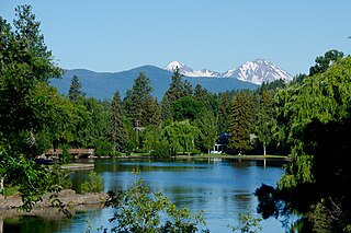
Mirror Pond is an impoundment of the Deschutes River in Bend, in the U.S. state of Oregon. It is between Pacific Power's Bend Hydro dam and the Colorado dam, between RM 166 and 167. The pond is flanked by Drake, Harmon, Pageant, Brooks, Columbia, Miller's Landing, and McKay parks, as well as a number of buildings such as Pine Tavern and private homes. Some people mistakenly consider the Galveston (Tumalo) bridge the upper boundary of Mirror Pond; others call the portion of the lake between Galveston bridge and the Colorado dam "upper Mirror Pond".

Pelton Dam is a major dam on the Deschutes River in Jefferson County, Oregon, owned and operated as a hydroelectric facility by Portland General Electric, one element of its Pelton Round Butte Project on the Deschutes.
Haystack Dam is a dam in central Oregon, about ten miles south of Madras.
The Crooked River Railroad Bridge, part of a BNSF Railway line between the Columbia River and Bend, Oregon, crosses Oregon's Crooked River Canyon in southern Jefferson County. The bridge is 320 feet (98 m) above the river and when it was completed in 1911, it was the second-highest railroad bridge in the United States. It is a steel two-hinge arch span with a total length of 460 feet (140 m).

The Upper North Fork Feather River Project is a hydroelectric scheme in the Sierra Nevada of California, within Lassen and Plumas Counties. The project consists of three dams, five power plants, and multiple conduits and tunnels in the headwaters of the North Fork Feather River, a major tributary of the Feather—Sacramento River systems. The total installed capacity is 362.3 megawatts (MW), producing an annual average of 1,171.9 gigawatt hours (GWh). The project is also contracted for the delivery of irrigation water between March 31 and October 31 of each year. The project is owned and operated by Pacific Gas and Electric Company.

Cline Falls is a 20 ft-high (6.1 m) segmented steep cascade waterfall on the Deschutes River. It is approximately 4 miles (6.4 km) west of Redmond, Oregon, United States. The waterfall is named for Cass A. Cline, who owned the land adjacent to the falls in the early 20th century. The falls occur just north of the point where Oregon Route 126 crosses the Deschutes River. The riparian area around Cline Falls provides habitat for a variety of fish and wildlife species.
