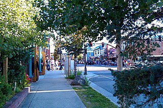
Breckenridge is a Home Rule Municipality that is the county seat and the most populous municipality of Summit County, Colorado, United States. The town population was 4,540 at the 2010 United States Census. The town also has many part-time residents, as many people have vacation homes in the area. The town is located at the base of the Tenmile Range.

South Park is a grassland flat within the basin formed by the Rocky Mountains' Mosquito and Park Mountain Ranges within central Colorado. This high valley ranges in elevation from approximately 9,000 to 10,000 ft. It encompasses approximately 1,000 square miles around the headwaters of the South Platte River in Park County approximately 60 mi (100 km) southwest of Denver. It is the largest and southernmost of three similarly named high altitude basins in the Front Range of Colorado, the others being North Park and Middle Park. The largest town in the basin is Fairplay, with a population of 681.

The San Miguel River is a tributary of the Dolores River, approximately 81 miles (130 km) long, in southwestern Colorado in the United States. It rises in the San Juan Mountains southeast of Telluride and flows northwest, along the southern slope of the Uncompahgre Plateau, past the towns of Placerville and Nucla and joins the Dolores in western Montrose County approximately 15 miles (24 km) east of the state line with Utah.

The Little Snake River is a tributary of the Yampa River, approximately 155 miles (249 km) long, in southwestern Wyoming and northwestern Colorado in the United States.

Roaring Fork River is a tributary of the Colorado River, approximately 70 miles (110 km) long, in west central Colorado in the United States. The river drains a populated and economically vital area of the Colorado Western Slope called the Roaring Fork Valley or Roaring Fork Watershed, which includes the resort city of Aspen and the resorts of Aspen/Snowmass.

The San Rafael River is a tributary of the Green River, approximately 90 miles (140 km) long, in east central Utah in the United States. The river flows across a sparsely populated arid region of the Colorado Plateau, and is known for the isolated, scenic gorge through which it flows.

The Verde River is a major tributary of the Salt River in the U.S. state of Arizona. It is about 170 miles (270 km) long and carries a mean flow of 602 cubic feet per second (17.0 m3/s) at its mouth. It is one of the largest perennial streams in Arizona.

The Conejos River is a tributary of the Rio Grande, approximately 92.5 miles (148.9 km) long, in south-central Colorado in the United States. It drains a scenic area of the eastern San Juan Mountains west of the San Luis Valley.
The Canadian River is a tributary of the North Platte River, approximately 55 miles (89 km) long, located in Jackson County in north central Colorado in the United States. It drains the eastern edge of the North Park basin along the western side of Medicine Bow Mountains.
Hoosier Pass elevation 11,542 ft (3,518 m) is a high mountain pass in the Rocky Mountains of central Colorado in the United States. The name derives from Indiana, nicknamed the "Hoosier State," which was the original home of many pioneers.

The Snake River is a short tributary of the Blue River, approximately 15 miles (24 km) long, in central Colorado in the United States. It drains a mountainous area on the west side of the Front Range in southeastern Summit County east of Keystone.

Plateau Creek is a tributary of the Colorado River, approximately 50 miles (80 km) long, located in western Colorado in the United States. It drains a cattle ranching valley, known as Plateau Valley, north of the Grand Mesa and east of Grand Junction.

The Grand Valley is an extended populated valley, approximately 30 miles (48 km) long and 5 miles (8 km) wide, located along the Colorado River in Mesa County, Colorado and Grand County, Utah in the United States. The valley contains the city of Grand Junction, as well as other smaller communities such as Fruita, and Palisade. The valley is noted as a major fruit-growing region, with a large number of orchards. It takes its name from the "Grand River", the historical name of the Colorado River upstream from its confluence with the Green River that was used by locals in the late 19th and early 20th century. The valley is the most densely populated area on the Colorado Western Slope, with Grand Junction serving as an unofficial capital of the region, as a counterpoint to Denver on the eastern slope of the Rocky Mountains in the Colorado Front Range. Interstate 70 and U.S. Highway 6 run through the valley from west-to-east. The Grand Valley is part of the larger Colorado Plateau desert lands.

Boreas Pass, elevation 11,481 ft (3,499 m), is a high mountain pass in the Rocky Mountains of central Colorado in the United States. The pass is located on the continental divide, at the crest of the Front Range along the border between Park (south) and Summit counties.

Curecanti National Recreation Area is a National Park Service unit located on the Gunnison River in western Colorado. Established in 1965, Curecanti is responsible for developing and managing recreational facilities on three reservoirs, Blue Mesa Reservoir, Morrow Point Reservoir and Crystal Reservoir, constructed on the upper Gunnison River in the 1960s by the U.S. Bureau of Reclamation to better utilize the vital waters of the Colorado River and its major tributaries. A popular destination for boating and fishing, Curecanti offers visitors two marinas, traditional and group campgrounds, hiking trails, boat launches, and boat-in campsites. The state's premiere lake trout and Kokanee salmon fisheries, Curecanti is a popular destination for boating and fishing, and is also a popular area for ice-fishing in the winter months.

Dillon Reservoir, sometimes referred to as Lake Dillon, is a large fresh water reservoir located in Summit County, Colorado, south of I-70 and bordered by the towns of Frisco, Silverthorne, and Dillon. It is a reservoir for the city of Denver, and its waters are under the control of Denver Water. Popular ski areas are close to the reservoir, including Copper Mountain, Keystone, Arapahoe Basin, and Breckenridge.

West Branch Pine Creek is a tributary of Pine Creek in Potter County, in Pennsylvania, in the United States. It is approximately 17.0 miles (27.4 km) long and flows through Summit Township, West Branch Township, and Galeton.

The Puerco River or Rio Puerco is a tributary of the Little Colorado River in northwestern New Mexico and northeastern Arizona. It flows through arid terrain, including the Painted Desert.

The Williams Fork is a tributary of the Colorado River, approximately 33.8 miles (54.4 km) long, in north central Colorado in the United States. It flows through Grand County between the valleys of the Fraser River and the Blue River. It rises at the juncture of McQueary and Bobtail creeks just west of the Continental Divide 8 miles (13 km) west of Berthoud Pass and 7 miles (11 km) north of the Eisenhower Tunnel in the Arapaho National Forest. It flows north-northwest to the Williams Fork Reservoir, then turns northeast and joins the Colorado at Parshall.


