Sydney on Vaal

Last updated
Sydney on Vaal
South Africa Northern Cape location map.svg
Red pog.svg
Sydney on Vaal
South Africa adm location map.svg
Red pog.svg
Sydney on Vaal
Coordinates: 28°26′28″S24°18′58″E / 28.441°S 24.316°E / -28.441; 24.316 Coordinates: 28°26′28″S24°18′58″E / 28.441°S 24.316°E / -28.441; 24.316
Country South Africa
Province Northern Cape
District Frances Baard
Municipality Dikgatlong
Area
[1]
  Total0.59 km2 (0.23 sq mi)
Population
(2011) [1]
  Total33
  Density56/km2 (140/sq mi)
Racial makeup (2011)
[1]
   Black African 3.0%
   Coloured 24.2%
   White 72.7%
First languages (2011)
[1]
   Afrikaans 75.8%
   English 21.2%
   Xhosa 3.0%
Time zone UTC+2 (SAST)

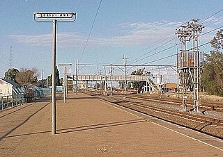
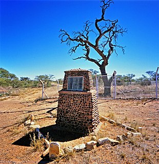
Sydney on Vaal is a ghost-town in Frances Baard District Municipality in the Northern Cape province of South Africa. The village lies 30 km northwest of Barkly West and several kilometres south of Delportshoop. It was founded in 1902 and is variously said to be named after Sidney Mendelssohn, Director of the Vaal River Diamond and Exploration Company which owned the land, as well as after its situation on the Vaal River, and after Sydney Shippard, Acting Attorney of the Executive Council of Griqualand West in 1872. [2]

Frances Baard District Municipality District municipality in Northern Cape, South Africa

Frances Baard is one of the 5 districts of Northern Cape province of South Africa. The seat of Frances Baard is Kimberley. The majority of its 324 814 people speak Setswana. The district code is DC9.

Northern Cape Province of South Africa

The Northern Cape is the largest and most sparsely populated province of South Africa. It was created in 1994 when the Cape Province was split up. Its capital is Kimberley. It includes the Kalahari Gemsbok National Park, part of the Kgalagadi Transfrontier Park, an international park shared with Botswana. It also includes the Augrabies Falls and the diamond mining regions in Kimberley and Alexander Bay. The Namaqualand region in the west is famous for its Namaqualand daisies. The southern towns of De Aar and Colesberg, in the Great Karoo, are major transport nodes between Johannesburg, Cape Town and Port Elizabeth. In the northeast, Kuruman is known as a mission station and also for its artesian spring, the Eye of Kuruman. The Orange River flows through the province, forming the borders with the Free State in the southeast and with Namibia to the northwest. The river is also used to irrigate the many vineyards in the arid region near Upington.

South Africa Republic in the southernmost part of Africa

South Africa, officially the Republic of South Africa (RSA), is the southernmost country in Africa. It is bounded to the south by 2,798 kilometres (1,739 mi) of coastline of Southern Africa stretching along the South Atlantic and Indian Oceans; to the north by the neighbouring countries of Namibia, Botswana, and Zimbabwe; and to the east and northeast by Mozambique and Eswatini (Swaziland); and it surrounds the enclaved country of Lesotho. South Africa is the largest country in Southern Africa and the 25th-largest country in the world by land area and, with over 57 million people, is the world's 24th-most populous nation. It is the southernmost country on the mainland of the Old World or the Eastern Hemisphere. About 80 percent of South Africans are of Sub-Saharan African ancestry, divided among a variety of ethnic groups speaking different African languages, nine of which have official status. The remaining population consists of Africa's largest communities of European (White), Asian (Indian), and multiracial (Coloured) ancestry.

Related Research Articles

Orange Free State independent Boer sovereign republic in southern Africa

The Orange Free State was an independent Boer sovereign republic in southern Africa during the second half of the 19th century, which later became a British colony and a province of the Union of South Africa. It is the historical precursor to the present-day Free State province. Extending between the Orange and Vaal rivers, its borders were determined by the United Kingdom of Great Britain and Ireland in 1848 when the region was proclaimed as the Orange River Sovereignty, with a seat of a British Resident in Bloemfontein.

Orange River river

The Orange River is the longest river in South Africa and the Orange River Basin extends extensively into Namibia and Botswana to the north. It rises in the Drakensberg mountains in Lesotho, flowing westwards through South Africa to the Atlantic Ocean. The river forms part of the international borders between South Africa and Namibia and between South Africa and Lesotho, as well as several provincial borders within South Africa. Except for Upington, it does not pass through any major cities. The Orange River plays an important role in the South African economy by providing water for irrigation and hydroelectric power. The river was named the Orange River in honour of the Dutch ruling family, the House of Orange, by the Dutch explorer Robert Jacob Gordon. Other names include Gariep River, Groote River or Senqu River.

Vaal River river in South Africa

The Vaal River is the largest tributary of the Orange River in South Africa. The river has its source near Breyten in Mpumalanga province, east of Johannesburg and about 30 kilometres (19 mi) north of Ermelo and only about 240 kilometres (150 mi) from the Indian Ocean. It then flows westwards to its conjunction with the Orange River southwest of Kimberley in the Northern Cape. It is 1,120 kilometres (700 mi) long, and forms the border between Mpumalanga, Gauteng and North West Province on its north bank, and the Free State on its south.

Vereeniging Place in Gauteng, South Africa

Vereeniging is a city in Gauteng province, South Africa, situated where the Klip River empties into the northern loop of the Vaal River. It is also one of the constituent parts of the Vaal Triangle region and was formerly situated in the Transvaal province. The name Vereeniging is derived from the Dutch word meaning "association" or "union".

Orkney, North West Place in North West, South Africa

Orkney is a gold mining town situated in the Klerksdorp district of the North West province, South Africa. It lies on the banks of the Vaal River approximately 180 km from Johannesburg near the N12.

Vanderbijlpark Place in Gauteng, South Africa

Vanderbijlpark is an industrial city with 95 000 inhabitants on the Vaal River in the south of the Gauteng province of South Africa.

Bothaville Place in Free State, South Africa

Bothaville is a maize farming town situated near the Vaal River in the Lejweleputswa DM of the Free State province, South Africa. It is situated 60 km east of the Vaal, on the bank of its Vals River tributary. Bothaville and the adjacent Kgotsong township have a total of approximately 46,000 residents.

Oranjeville Place in Free State, South Africa

Oranjeville is a small town situated on the banks of the Wilge River in the Free State province of South Africa.

Villiers, Free State Place in Free State, South Africa

Villiers is a small town situated on the banks of the Vaal River next to the N3 highway in the Free State province of South Africa. It was founded in 1882 on the two farms Pearson Valley and Grootdraai owned by Lourens de Villiers.

Christiana, North West Place in North West, South Africa

Christiana is an agricultural town of about 16,000 inhabitants on the banks of the Vaal River in North West province, South Africa The town is located on the N12 national route between Bloemhof and Warrenton, on the way to Kimberley. It is the administrative centre of Lekwa-Teemane Local Municipality.

Makwassie Place in North West, South Africa

Makwassie is a small farming town situated in North West Province of South Africa that produces maize, sorghum, groundnuts and milk. The word makwassie is a corruption of the San word for an aromatic wild spearmint.

Barkly West Place in Northern Cape, South Africa

Barkly West is a town in the Northern Cape province of South Africa, situated on the north bank of the Vaal River west of Kimberley.

Warrenton, Northern Cape Place in Northern Cape, South Africa

Warrenton is an agricultural town of approximately 18,000 people in the Northern Cape province of South Africa, situated 70 kilometres (40 mi) north of Kimberley on the Vaal River.

Windsorton Place in Northern Cape, South Africa

Windsorton is an agricultural town situated in the Vaalharts Irrigation Scheme on the banks of the Vaal River in the Northern Cape province of South Africa.

Sedibeng District Municipality District municipality in Gauteng, South Africa

Sedibeng is one of the districts of the Gauteng province of South Africa. The administrative seat of Sedibeng is Vereeniging. The most widely spoken language among its 794,605 inhabitants is Sesotho.

Sand River (Free State) river in the Free State, South Africa

The Sand River is a river in the Free State, South Africa. It is located close to Welkom and Virginia in the gold mining center of the Free State. Its source is located close to Tweefontein NW of Ficksburg not far from the South Africa/Lesotho border, at 28°40′49″S27°41′23″E. This river is famous because of the historical Sand River Convention, an important event in South African history.

Tlokwe Local Municipality Local municipality in North West, South Africa

Tlokwe Local Municipality was a local municipality in Dr Kenneth Kaunda District Municipality, North West Province, South Africa. The seat was Potchefstroom. After the municipal elections on 3 August 2016 it was merged into the larger JB Marks Local Municipality.

Vals River river in South Africa

The Vals River is a tributary of the Vaal River in the Free State, South Africa. It is a strong seasonal river.

Mooi River (Vaal) river in South Africa

The Mooi River is a river in North West Province, South Africa. It is a tributary of the Vaal River and belongs to the Upper Vaal Water Management Area.

References

  1. 1 2 3 4 "Main Place Sydney on Vaal". Census 2011.
  2. "Dictionary of Southern African Place Names (Public Domain)". Human Science Research Council. p. 425.