
The Orange Free State was an independent Boer sovereign republic under British suzerainty in Southern Africa during the second half of the 19th century, which ceased to exist after it was defeated and surrendered to the British Empire at the end of the Second Boer War in 1902. It is one of the three historical precursors to the present-day Free State province.

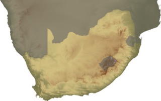
The Orange River is a river in Southern Africa. It is the longest river within the borders of South Africa and the Orange River Basin extends extensively from Lesotho into South Africa and Namibia to the north. It rises in the Drakensberg mountains in Lesotho, flowing westwards through South Africa to the Atlantic Ocean. The river forms part of the international borders between South Africa and Lesotho and between South Africa and Namibia, as well as several provincial borders within South Africa. Except for Upington, it does not pass through any major cities. The Orange River plays an important role in the South African economy by providing water for irrigation and hydroelectric power. The river was named the Orange River in honour of the Dutch ruling family, the House of Orange, by the Dutch explorer Robert Jacob Gordon. Other names include simply the word for river, in Khoekhoegowab orthography written as !Garib, which is rendered in Afrikaans as Gariep River with the intrusion of a velar fricative in place of the alveolar click, Groote River or Senqu River, derived from ǂNū "Black".

The Vaal River is the largest tributary of the Orange River in South Africa. The river has its source near Breyten in Mpumalanga province, east of Johannesburg and about 30 kilometres (19 mi) north of Ermelo and only about 240 kilometres (150 mi) from the Indian Ocean. It then flows westwards to its conjunction with the Orange River southwest of Kimberley in the Northern Cape. It is 1,120 kilometres (700 mi) long, and forms the border between Mpumalanga, Gauteng and North West Province on its north bank, and the Free State on its south.

Kimberley is the capital and largest city of the Northern Cape Province of South Africa. It is located approximately 110 km east of the confluence of the Vaal and Orange Rivers. The city has considerable historical significance due to its diamond mining past and the siege during the Second Anglo-Boer war. British businessmen Cecil Rhodes and Barney Barnato made their fortunes in Kimberley, and Rhodes established the De Beers diamond company in the early days of the mining town.
Griqualand West is an area of central South Africa with an area of 40,000 km2 that now forms part of the Northern Cape Province. It was inhabited by the Griqua people – a semi-nomadic, Afrikaans-speaking nation of mixed-race origin, who established several states outside the expanding frontier of the Cape Colony. It was also inhabited by the pre-existing Tswana and Khoisan peoples.

Klerksdorp is located in the North West Province, South Africa. Klerksdorp used to be the largest city in the North West Province located south-easterly to Mahikeng. Mahikeng, the provincial capital, lies roughly 170 km north-west of Klerksdorp and Johannesburg 170 km in a north-eastern direction.

Vereeniging is a city located in the south of Gauteng province, South Africa, situated where the Klip River empties into the northern loop of the Vaal River. It is also one of the constituent parts of the Vaal Triangle region and was formerly situated in the Transvaal province. The name Vereeniging is derived from the Dutch word meaning "union".

Vanderbijlpark is an industrial city with approximately 75 000 inhabitants, and 95 000 inhabitants in the metropole, situated on the Vaal River in the south of Gauteng province, South Africa. The city is named after Hendrik van der Bijl, an electrical engineer and industrialist.

Winburg is a small mixed farming town in the Free State province of South Africa.

Villiers is a small town situated on the banks of the Vaal River next to the N3 highway in the Free State province of South Africa. It was founded in 1882 on the two farms Pearson Valley and Grootdraai owned by Lourens de Villiers.
Bloemhof is an agricultural town of about 2,000 inhabitants situated on the banks of the Vaal River in North West Province of South Africa.
Christiana is an agricultural town of about 3000 inhabitants on the banks of the Vaal River in North West province, South Africa The town is located on the N12 national route between Bloemhof and Warrenton, on the way to Kimberley. It is the administrative centre of Lekwa-Teemane Local Municipality.

Wolmaransstad is a maize-farming town situated on the N12 between Johannesburg and Kimberley in North West Province of South Africa. The town lies in an important alluvial diamond-mining area and it is the main town of the Maquassi Hills Local Municipality.
Barkly West is a town in the Northern Cape province of South Africa, situated on the north bank of the Vaal River west of Kimberley.
The Vaalharts Irrigation Scheme is one of the largest irrigation schemes in the world covering 369.50 square kilometres in the Northern Cape Province of South Africa. It is named after the Vaal River and the Harts River, the Vaal River being its major tributary.

The Harts River is a northern tributary of the Vaal River, which in turn is the largest tributary of the Orange River. Its source is in the North West Province, but the greater part of its basin is located in the Northern Cape Province, which it enters a few kilometers downstream from the Taung Dam.

The Nooitgedacht Glacial Pavements comprise a geological feature between Kimberley and Barkly West, South Africa, pertaining to the Palaeozoic-age Dwyka Ice Age, or Karoo Ice Age, where the glacially scoured ancient bedrock was used, substantially more recently, during the Later Stone Age period in the late Holocene as panels for rock engravings.
Canteen Kopje is an archaeological site, formally protected as a grade 2 provincial heritage site, and approved in 2017 for re-grading to national status, situated outside Barkly West in the Northern Cape, South Africa. The place was previously known as Klipdrift, meaning stony drift, a translation from a still earlier !Ora name, !a |aub. Canteen Kopje is best known for its long and exceptionally rich Earlier Stone Age sequence, spanning circa >0.5 to 1.7 million years, occurring within gravels exposed in late nineteenth/early twentieth century mining pits. Also attracting attention are more recent archaeological levels in the overlying Hutton Sands, which contain material known as Fauresmith, Middle Stone Age, Later Stone Age, and late Iron Age with evidence of protocolonial/colonial contact and interaction, probably, with nineteenth century diamond diggers.

Delportshoop is a town in Frances Baard District Municipality in the Northern Cape Province of South Africa. It lies next to the Vaal River. The Harts River runs by closely.
Sydney on Vaal is a ghost-town in Frances Baard District Municipality in the Northern Cape province of South Africa. The village lies 30 km northwest of Barkly West and several kilometres south of Delportshoop. It was founded in 1902 and is variously said to be named after Sidney Mendelssohn, Director of the Vaal River Diamond and Exploration Company which owned the land, as well as after its situation on the Vaal River, and after Sydney Shippard, Acting Attorney of the Executive Council of Griqualand West in 1872.


