Secondary education or post-primary education covers two phases on the International Standard Classification of Education scale. Level 2 or lower secondary education is considered the second and final phase of basic education, and level 3 upper secondary education or senior secondary education is the stage before tertiary education. Every country aims to provide basic education, but the systems and terminology remain unique to them. Secondary education typically takes place after six years of primary education and is followed by higher education, vocational education or employment. In most countries secondary education is compulsory, at least until the age of 16. Children typically enter the lower secondary phase around age 12. Compulsory education sometimes extends to age 20.

A student is a person enrolled in a school or other educational institution.
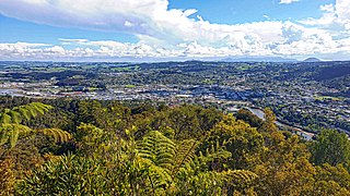
Whangārei is the northernmost city in New Zealand and the regional capital of Northland Region. It is part of the Whangārei District, a local body created in 1989 from the former Whangārei City, Whangārei County and Hikurangi Town councils, to administer both the city proper and its hinterland. The city population was estimated to be 54,900 in June 2022, an increase from 47,000 in 2001.
Pietermaritzburg is the capital and second-largest city in the province of KwaZulu-Natal, South Africa. It was founded in 1838 and is currently governed by the Msunduzi Local Municipality. Its Zulu name umGungundlovu is the name used for the Umgungundlovu District Municipality. Pietermaritzburg is popularly called Maritzburg in Afrikaans, English and Zulu alike, and often informally abbreviated to PMB. It is a regionally important industrial hub, producing aluminium, timber and dairy products, as well as the main economic hub of Umgungundlovu District Municipality. The public sector is a major employer in the city due to local, district and provincial government offices located here.

Ballyclare is a small town in County Antrim, Northern Ireland. It had a population of 9,953 according to the 2011 census, and is located within the Antrim and Newtownabbey Borough Council area.
Woodlands is a planning area and residential town located in the North of Singapore. As of 2019, the town has a population of 254,733. Located approximately 25 km (16 mi) north of the central business district (CBD), it is the densest planning area and is the regional centre for the northern parts of the country.

Choa Chu Kang, alternatively spelled Chua Chu Kang and often abbreviated as CCK, is a planning area and residential town located at the northwestern point of the West Region of Singapore. The town shares borders with Sungei Kadut to the north, Tengah to the southwest, Bukit Batok to the southeast, Bukit Panjang to the east and the Western Water Catchment to the west. Choa Chu Kang New Town is separated into two portions by the Kranji Expressway.
Seventh grade is the seventh year of formal or compulsory education. The seventh grade is typically the first or second year of middle school. Children in seventh grade are around 12–13 years old. Different terms and numbers are used in other parts of the world.
Hartswater is an agricultural town on the N18 national route some 23 km south of Taung and 36 km north of Warrenton. The centre of the Vaalharts Irrigation Scheme, it became a municipality in April 1960. It takes its name from the Harts River which passes to the west of the town.
Chegutu, originally known as Hartley, is a town in Mashonaland West Province, Zimbabwe.

Alipurduar is a city and a municipality in the Indian state of West Bengal. It is the headquarters of the Alipurduar district. Situated on the east bank of Kaljani River on the foothills of the Himalayas, the city is a gateway to Bhutan and northeastern states of India. Alipurduar was a sub-divisional town of Jalpaiguri district until 2014 when it was created a separate district.
Educational stages are subdivisions of formal learning, typically covering early childhood education, primary education, secondary education and tertiary education. The United Nations Educational, Scientific and Cultural Organization (UNESCO) recognizes nine levels of education in its International Standard Classification of Education (ISCED) system. UNESCO's International Bureau of Education maintains a database of country-specific education systems and their stages. Some countries divide levels of study into grades or forms for school children in the same year.

The Southern Suburbs are a group of Anglophone suburbs in Cape Town, Western Cape, South Africa. This group includes, among others, Observatory, Mowbray, Pinelands, Rosebank, Rondebosch, Rondebosch East, Newlands, Claremont, Lansdowne, Kenilworth, Bishopscourt, Constantia, Wynberg, Ottery, Plumstead, Diep River, Bergvliet and Tokai. The area is also commonly referred to as the Cape Peninsula, often including the towns further South such as Fish Hoek.
New Barrackpore is a city and a municipality in North 24 Parganas district in the Indian state of West Bengal. It is close to Kolkata and a part of the area covered by Kolkata Metropolitan Development Authority (KMDA).

Lake Munmorah is a suburb of the Central Coast region of New South Wales, Australia. It is part of the Central Coast Council local government area.

Kikuyu is a town in Kiambu County, Kenya, which grew from a settlement of colonial missionaries. The town is located about 20 km (12 mi) northwest of central Nairobi. It is about 20 minutes from Nairobi via a number of routes, including a dual carriage road, and has a railway station on the Mombasa – Malaba Railway Line. The town is named after the Kikuyu/Gĩkũyũ people, the major ethnicity that settled in the area. As of 2019 the total population is 323,881.
Wanneroo is a northern suburb of Perth, Western Australia, located within the City of Wanneroo.
Senwabarwana, also known as Bochum, is a town in the Blouberg Local Municipality of the Capricorn District Municipality in the Limpopo province of South Africa. The town is the seat of the Blouberg Local Municipality. It is located about 93 km northwest of the city Polokwane.
Kalikapur is a census town and a gram panchayat within the jurisdiction of the Sonarpur police station in the Sonarpur CD block in the Baruipur subdivision of the South 24 Parganas district in the Indian state of West Bengal.
Sahebpur is a census town within the jurisdiction of the Sonarpur police station in the Sonarpur CD block in the Baruipur subdivision of the South 24 Parganas district in the Indian state of West Bengal.
People of Pampierstad majority were forcefully moved from Jan Kempdorp location and others from Hartswater Thagadiepelajang in the early 60's.


