
Olympus Mons is a large shield volcano on Mars. It is over 21.9 km high as measured by the Mars Orbiter Laser Altimeter (MOLA): about two and a half times taller than Mount Everest above sea level. It is Mars's tallest volcano, its tallest planetary mountain, and is approximately tied with Rheasilvia on Vesta as the tallest mountain currently discovered in the Solar System. It is associated with the volcanic region of Tharsis Montes. It last erupted 25 million years ago.
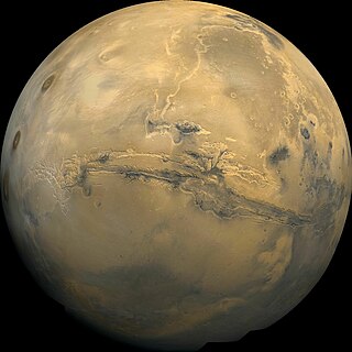
Valles Marineris is a system of canyons that runs along the Martian surface east of the Tharsis region. At more than 4,000 km (2,500 mi) long, 200 km (120 mi) wide and up to 7 km (23,000 ft) deep, Valles Marineris is the largest canyon in the Solar System.

Tharsis is a vast volcanic plateau centered near the equator in the western hemisphere of Mars. The region is home to the largest volcanoes in the Solar System, including the three enormous shield volcanoes Arsia Mons, Pavonis Mons, and Ascraeus Mons, which are collectively known as the Tharsis Montes. The tallest volcano on the planet, Olympus Mons, is often associated with the Tharsis region but is actually located off the western edge of the plateau. The name Tharsis is the Greco-Latin transliteration of the biblical Tarshish, the land at the western extremity of the known world.

Syrtis Major Planum is a massive shield volcano in the eastern hemisphere of Mars. A "dark spot", Syrtis Major Planum is located in the boundary between the northern lowlands and southern highlands of Mars just west of the impact basin Isidis in the Syrtis Major quadrangle. It was formerly believed to be a plain, and was therefore described as a planitia; later data from the Mars Global Surveyor revealed that it is actually a broad topographic rise. The dark color of Syrtis Major Planum comes from the basaltic volcanic rock of the region and the relative lack of dust.
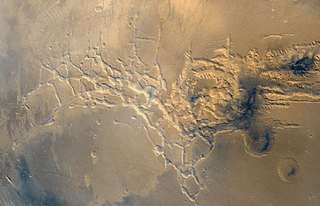
Noctis Labyrinthus is a region of Mars located in the Phoenicis Lacus quadrangle, between Valles Marineris and the Tharsis upland. The region is notable for its maze-like system of deep, steep-walled valleys. The valleys and canyons of this region formed by faulting and many show classic features of grabens, with the upland plain surface preserved on the valley floor. In some places the valley floors are rougher, disturbed by landslides, and there are places where the land appears to have sunk down into pit-like formations. It is thought that this faulting was triggered by volcanic activity in the Tharsis region. Research described in December 2009 found a variety of minerals, including clays, sulfates, and hydrated silicas, in some of the layers.

Pavonis Mons is a large shield volcano located in the Tharsis region of the planet Mars. It is the middle member of a chain of three volcanic mountains that straddle the Martian equator between longitudes 235°E and 259°E. The volcano was discovered by the Mariner 9 spacecraft in 1971, and was originally called Middle Spot. Its name formally became Pavonis Mons in 1973. The equatorial location of its peak and its height make it the ideal terminus for a space elevator, and it has often been proposed as a space elevator location, especially in science fiction. It is also an ideal location for a Sky Ramp.

Ascraeus Mons is a large shield volcano located in the Tharsis region of the planet Mars. It is the northernmost and tallest of three shield volcanoes collectively known as the Tharsis Montes.

Arsia Mons is the southernmost of three volcanoes on the Tharsis bulge near the equator of the planet Mars. To its north is Pavonis Mons, and north of that is Ascraeus Mons. The tallest volcano in the Solar System, Olympus Mons, is to its northwest. Its name comes from a corresponding albedo feature on a map by Giovanni Schiaparelli, which he named in turn after the legendary Roman forest of Arsia Silva. Historically, it was known as Nodus Gordii before being renamed.

The Tharsis Montes are three large shield volcanoes in the Tharsis region of the planet Mars. From north to south, the volcanoes are Ascraeus Mons, Pavonis Mons and Arsia Mons. Mons is the Latin word for mountain; it is a descriptor term used in astrogeology for mountainous features in the Solar System.

Chryse Planitia is a smooth circular plain in the northern equatorial region of Mars close to the Tharsis region to the west, centered at 28.4°N 319.7°E. Chryse Planitia lies partially in the Lunae Palus quadrangle, partially in the Oxia Palus quadrangle, partially in the Mare Acidalium quadrangle. It is 1600 km or 994 mi in diameter and with a floor 2.5 km below the average planetary surface altitude, and has been suggested to be an ancient buried impact basin, though this is contested. It has several features in common with lunar maria, such as wrinkle ridges. The density of impact craters in the 100 to 2,000 metres range is close to half the average for lunar maria.

The geology of Mars is the scientific study of the surface, crust, and interior of the planet Mars. It emphasizes the composition, structure, history, and physical processes that shape the planet. It is analogous to the field of terrestrial geology. In planetary science, the term geology is used in its broadest sense to mean the study of the solid parts of planets and moons. The term incorporates aspects of geophysics, geochemistry, mineralogy, geodesy, and cartography. A neologism, areology, from the Greek word Arēs (Mars), sometimes appears as a synonym for Mars's geology in the popular media and works of science fiction. The term areology is also used by the Areological Society.
Volcanic activity, or volcanism, has played a significant role in the geologic evolution of Mars. Scientists have known since the Mariner 9 mission in 1972 that volcanic features cover large portions of the Martian surface. These features include extensive lava flows, vast lava plains, and the largest known volcanoes in the Solar System. Martian volcanic features range in age from Noachian to late Amazonian, indicating that the planet has been volcanically active throughout its history, and some speculate it probably still is so today. Both Earth and Mars are large, differentiated planets built from similar chondritic materials. Many of the same magmatic processes that occur on Earth also occurred on Mars, and both planets are similar enough compositionally that the same names can be applied to their igneous rocks and minerals.

Tharsis Tholus is an intermediate-sized shield volcano located in the eastern Tharsis region of the planet Mars. The volcano was discovered by the Mariner 9 spacecraft in 1972 and originally given the informal name Volcano 7. In 1973, the International Astronomical Union (IAU) officially designated it Tharsis Tholus. In planetary geology, tholus is the term for a small domical mountain, usually a volcano.

The Phoenicis Lacus quadrangle is one of a series of 30 quadrangle maps of Mars used by the United States Geological Survey (USGS) Astrogeology Research Program. The Phoenicis Lacus quadrangle is also referred to as MC-17. Parts of Daedalia Planum, Sinai Planum, and Solis Planum are found in this quadrangle. Phoenicis Lacus is named after the phoenix which according to myth burns itself up every 500 years and then is reborn.

The Ceraunius Fossae are a set of fractures in the northern Tharsis region of Mars. They lie directly south of the large volcano Alba Mons and consist of numerous parallel faults and tension cracks that deform the ancient highland crust. In places, younger lava flows cover the fractured terrain, dividing it into several large patches or islands. They are found in the Tharsis quadrangle.

The Uranius group of volcanoes is located on planet Mars in the northeast part of Tharsis and includes Uranius Mons, Ceraunius Tholus, and Uranius Tholus. Along with the Tharsis Montes to the southwest, they form part of a linear chain of volcanoes in the Tharsis region.

Icaria Planum is a region on Mars in the Thaumasia quadrangle. It is located roughly south-southwest of the Tharsis Rise. Icaria Planum is named after the island of Ikaria, where, according to Greek mythology, Icarus fell and died in the sea.
For some time, scientists have thought that the location of the poles of Mars shifted due to the great mass of volcanic material in the Tharsis dome which includes Olympus Mons, the highest volcano in the Solar System. For a period early in the history of Mars, the poles were about 20 degrees away from their present geographic positions. At that time ice was deposited in a region called Dorsa Argentea Formation. Also, the Martian dichotomy was aligned along the equator. A band of rivers formed at around 25 degrees south carried water from the southern highlands to the northern lowlands. After the polar shift, the location of the dichotomy boundary and the band of river valleys shifted. Dorsa Argentea was no longer at the pole. To produce the change in the pole location, the tilt of the planet remained unchanged, rather the crust and mantle moved. They rotated around the core.

The Thaumasia Planum of Mars lies south of Melas Chasmata and Coprates Chasmata. It is in the Coprates quadrangle. Its center is located at 21.66 S and 294.78 E. It was named after a classical albedo feature. The name was approved in 2006. Some forms on its surface are evidence of a flow of lava or water the Melas Chasma. Many wrinkle ridges and grabens are visible. One set of grabens, called Nia Fossae, seem to follow the curve of Melas Chasmata which lies just to the north. Some researchers have discovered dikes in this region. For the study, Thermal Emission Imaging System (THEMIS) daytime infrared images, THEMIS nighttime infrared images, CTX images, and HiRISE images were used. These dikes contain magnesium-rich olivine which indicates a primitive magma composition. Dikes occur when magma follows cracks and faults under the ground. Sometimes erosion reveals them. The presence of pit craters, narrow grabens, linear troughs, and ovoid troughs are also evidence of dikes. These dikes that lie close to and parallel to Valles Marineris, the great canyon system, are evidence that extensional stress aided the formation of Valles Marineris. They may be part of a system of dikes that came from the same magma source that fed the whole area. That source may have been a “plume” of molted rock that rose from the Martian mantle.
The Thaumasia Plateau is a vast sloping volcanic plain in the western hemisphere of Mars, and is the most extensive component of the Tharsis Rise by area. Syria Planum, Solis Planum, Sinai Planum, and Thaumasia Planum are the constituent sectors of the plateau, which sits between 8 km and 4 km above the surrounding southern highlands. It is bounded by vestigial basement terrains that predate the formation of Tharsis. This area has been proposed to be a drainage basin that sourced the floodwaters forming the outflow channels surrounding Chryse Planitia.
