Tabora

Last updated

Tabora
Around Kanyenye Street ,Tabora Manicipality, Tanzania.jpg
Street scene in Tabora
Tanzania relief location map.svg
Red pog.svg
Tabora
Location of Tabora.
Coordinates: 5°1′S32°48′E / 5.017°S 32.800°E / -5.017; 32.800
Country Tanzania
Region Tabora Region
District Tabora Urban District
Area
   City of Tabora Region 564 sq mi (1,461 km2)
Population
 (2022 census) [1]
   City of Tabora Region 308,741
  Density550/sq mi (210/km2)
   Urban
[2]
221,466
Time zone UTC+3 (EAT)
  Summer (DST) EAT
Area code 026
Climate Aw
Website Regional website

Tabora [3] is the capital of Tanzania's Tabora Region and is classified as a municipality by the Tanzanian government. It is also the administrative seat of Tabora Urban District. According to the 2012 census, the district had a population of 226,999. [4]

Contents

History

Indian shops in the year 1906 during the day time. Bundesarchiv Bild 105-DOA0716, Deutsch-Ostafrika, Tabora, Inderladen.jpg
Indian shops in the year 1906 during the day time.

Beginning in the 1830s, coastal traders increasingly settled in the region to take advantage of the ivory and slave caravan trade. Swahili and Omani traders established Kazeh, near present-day Tabora, in the 1850s. By 1870, Tabora was home to a population of 5,000-10,000 people living in roughly fifty large square houses. These homes accommodated up to several hundred people each and had inner courtyards, adjacent garden plots, store rooms, servant quarters, and outbuildings for slaves.

The town was surrounded by Nyamwezi villages, whose people provided produce and caravan labor. In this period the Sultan of Zanzibar appointed a representative there. [5] It was part of the Kingdom of Unyanyembe. Tabora was a center of trade for traders from as far North as the Buganda Kingdom. By August 1871, one-quarter of the town was burned when the forces of the Nyamwezi ruler Mirambo sacked it. [6]

Allthough the German East Africa protectorate was proclaimed over the region in 1885, as late as 1891 travellers reported it to be a lawless town. The German colonial administration did not gain control of it until later that year. As a major station on the Central Line, it became the most important administrative centre of central German East Africa.

In 1916 the colonial garrison had an emergency mint at Tabora, making some gold pieces as well as large numbers of crude copper and brass German East African rupie minor coins, Mint marked with a "T". [7]

During the Tabora Offensive in the East African Campaign of World War I, colonial armed forces of the Belgian Congo (Force Publique) under the command of General Charles Tombeur captured the town on 19 September 1916 after 10 days and nights of heavy fighting. [8]

Socio-economic situation

Tabora and its people mainly rely on agricultural activities as either sustenance farmers or small-scale tobacco farmers. Tabora also hosts a ballast quarry.[ citation needed ]

Water supply is managed by the Tabora Urban Water Supply and Sanitation Authority (Tuwasa), sourced from Igombe and Kazima Dams. [9] The Igombe River is a tributary of the Malagarasi River and the Malagarasi-Muyovozi Wetlands.

Food and culture

Rice harvest in Igunga, Tabora, Tanzania Farmers harvesting rice.jpg
Rice harvest in Igunga, Tabora, Tanzania

Tabora's streets are lined with century-old mango trees planted by Omani traders. Tabora is known as the fruit capital of Western Tanzania, and markets are often filled with local produce.[ citation needed ]

Tabora has many small local restaurants offering typical Tanzanian restaurant food like Ugali (a thick maize porridge), chips, or rice with beans, beef or chicken. For breakfast or lunch, there is usually chipsi-mayai (chips and egg), which is basically a couple of eggs fried together with some chips. Although the food is bland, it is usually served with Tanzanian chili sauce, which gives the meal some character.[ citation needed ]

A local specialty is pumpkin in peanut butter sauce. This goes with the rice pilau served widely throughout the region.

For snacks there are local sambusa (samosa), some goat meat on a stick or some freshly roasted corn of the cob, all widely available in Tabora. There is a choice of fruit in the large regional market of Tabora, including pineapples, watermelons, and bananas.

Climate

Tabora has a tropical savanna climate (Köppen Aw) with two seasons of approximately equal length. The wet season is from November to April and is followed by a dry season from May to October.

Climate data for Tabora (1991–2020)
MonthJanFebMarAprMayJunJulAugSepOctNovDecYear
Mean daily maximum °C (°F)28.8
(83.8)
29.4
(84.9)
29.6
(85.3)
29.4
(84.9)
29.7
(85.5)
29.7
(85.5)
29.8
(85.6)
30.9
(87.6)
32.3
(90.1)
32.6
(90.7)
31.1
(88.0)
29.1
(84.4)
30.2
(86.4)
Mean daily minimum °C (°F)18.3
(64.9)
18.0
(64.4)
17.9
(64.2)
17.6
(63.7)
16.5
(61.7)
14.7
(58.5)
14.6
(58.3)
16.5
(61.7)
18.3
(64.9)
19.4
(66.9)
19.1
(66.4)
18.6
(65.5)
17.5
(63.5)
Average rainfall mm (inches)162.1
(6.38)
142.7
(5.62)
153.4
(6.04)
105.8
(4.17)
29.2
(1.15)
1.9
(0.07)
0.9
(0.04)
0.9
(0.04)
9.3
(0.37)
26.0
(1.02)
109.4
(4.31)
202.2
(7.96)
943.8
(37.16)
Average rainy days (≥ 1.0 mm)13.110.311.18.02.90.20.10.21.13.19.115.774.9
Source: NOAA [10]

Transport

Tabora Airport Tabora Airport.jpg
Tabora Airport

Tabora is small enough to walk from one side of town to the other. Bicycle taxis, motorbike taxis and regular taxis are available.

Tabora at the moment is served by mostly paved road T18 from Singida Region to Kigoma and partly unpaved road T8 from Mbeya to Mwanza passing through the district. [11] Salt flats to the west prevent a direct road from connecting to Kigoma.

In January 2013, the Tanzanian government announced the commencement of work to upgrade to tarmac level the Tabora-Urambo road and the 127 kilometres (79 mi) Nyahua-Tabora-Ndono road. [12] In December 2012, Prime Minister Mizengo Pinda stated the Tanzanian government's intent to upgrade the 359 kilometres (223 mi) Tabora-Inyonga-Mpanda road to tarmac level before 2015. [13] In August 2011, Deputy Minister for Works Harrison Mwakyembe told the National Assembly that the government had begun to tarmac the 115 kilometres (71 mi) Tabora-Puge-Nzega road. [14]

Tabora is served and is a junction on the Central railway line, which goes east to Dar es Salaam, west to Kigoma on to the Lake Tanganyika and north to the port of Mwanza on Lake Victoria. Trains leave three times a week in any direction.

In 2017, a new station on the standard gauge railway is proposed.

Airport

Tabora is served by the Tabora Airport which is located 7 kilometers south of the centre of town. Renovation of the airport was completed in 2015.

Precision Air started flying to the airport three times a week on Monday, Wednesday and Friday, east from Julius Nyerere International Airport Dar es Salaam and west from Kigoma. [15]

Education

Tabora is home to a number of educational institutions, including:

Tabora Girls Secondary School

A public boarding school located in Tabora, Tanzania. [16] It was established in 1928 by the British Colonial rulers. [16] [17] It is one of the oldest girls only school in Tanzania. [18] The school was originally established to educate the daughters of local chiefs as prospective wives of other chiefs sons who were also educated around the same area at Tabora Boys Secondary School. [17] [19]

The school has produced students who were among the first women leaders in the country, such as Anna Abdallah one of the first woman district commissioners, [20] Julie Manning the first woman to study law in Tanzania, [21] Getrude Mongella the first President of the Pan-African Parliament. [19] [22]

Tabora Boys Secondary School

A public school in Tanzania founded in 1922. The school was established to educate sons of African Chiefs and wealthy tribesmen. [23] [24] [25] The school first followed a tribal structure where students were assigned to dormitories based on their tribe, and received education on their respective tribal customs. [25] [16] In its early days the school was considered the 'Eton of Tanganyika'. [26] [27]

The first self-government cabinet in 1961 had eight ministers whose five were all from Tabora Boys. [28] [29]

Among the famous people who studied at this school are Rashidi Kawawa and the father of the Tanzanian nation, Mwalimu Julius Nyerere. [30]

See also

Related Research Articles

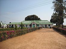
Transport in Tanzania includes road, rail, air and maritime networks. The road network is 86,472 kilometres (53,731 mi) long, of which 12,786 kilometres (7,945 mi) is classified as trunk road and 21,105 kilometres (13,114 mi) as regional road. The rail network consists of 3,682 kilometres (2,288 mi) of track. Commuter rail service is in Dar es Salaam only. There are 28 airports, with Julius Nyerere International being the largest and the busiest. Ferries connect Mainland Tanzania with the islands of Zanzibar. Several other ferries are active on the countries' rivers and lakes.

<span class="mw-page-title-main">Mwanza</span> City of Mwanza Region in Tanzania

Mwanza City, also known as Rock City to the residents, is a port city and capital of Mwanza Region on the southern shore of Lake Victoria in north-western Tanzania. With an urban population of 1,311,000 in 2023, it is Tanzania's second largest city, after Dar es Salaam. It is also the second largest city in the Lake Victoria basin after Kampala, Uganda and ahead of Kisumu, Kenya at least in population size. Within the East African community, Mwanza city is the fifth largest city after Dar, Nairobi, Mombasa, and Kampala. It is slightly ahead of Kigali, Kisumu, and Bujumbura in the population of city proper limits. Mwanza city is also the capital city of Mwanza Region, and is administratively divided into two municipal districts within that Region - Ilemela and Nyamagana.

<span class="mw-page-title-main">Kigoma</span> City and lake port in Kigoma Region, Tanzania

Kigoma is a city and lake port in Kigoma-Ujiji District in Tanzania, on the northeastern shores of Lake Tanganyika and close to the border with Burundi and The Democratic Republic of the Congo. It serves as the capital for the surrounding Kigoma Region and has a population of 232,388. The city is situated at an elevation of 775 metres (2,543 ft).

<span class="mw-page-title-main">Kigoma Region</span> Region of Tanzania

Kigoma Region is one of Tanzania's 31 administrative regions. The regional capital is the city of Kigoma. Kigoma Region borders Kagera Region, Geita Region, Katavi Region, Tabora Region, DRC and Burundi According to the 2012 national census, the region had a population of 2,127,930, which was higher than the pre-census projection of 1,971,332. For 2002-2012, the region's 2.4 percent average annual population growth rate was tied for the fourteenth highest in the country. It was also the sixteenth most densely populated region with 57 people per square kilometer. With a size of 45,066 square kilometres (17,400 sq mi), the region is slightly smaller than Estonia.

<span class="mw-page-title-main">Central Line (Tanzania)</span> Railway line in Tanzania

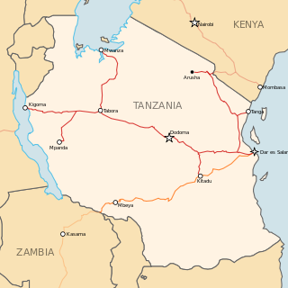
The Central Line, formerly known as the Tanganyika Railway is the most important railway line in Tanzania, apart from TAZARA. It runs west from Dar es Salaam to Kigoma on Lake Tanganyika via Dodoma. A branch leads to Mwanza on Lake Victoria.

<span class="mw-page-title-main">Mwanza Region</span> Region of Tanzania

Mwanza Region is one of Tanzania's 31 administrative regions. The region covers a land area of 25,233 km2 (9,743 sq mi). The region is comparable in size to the combined land area of the nation state of North Macedonia. Mwanza Region is bordered to the north through Lake Victoria by the Kagera Region and Mara Region, to the east by Simiyu Region, to the south by the Shinyanga Region and to the west by Geita Region. The regional capital is the city of Mwanza. According to the 2022 national census, the region had a population of 3,699,872 and national census of 2012 had 2,772,509. Mwanza Region is the second region with high population in Tanzania after Dar es Salaam Region.

<span class="mw-page-title-main">Tabora Region</span> Region of Tanzania

Tabora Region is one of Tanzania's 31 administrative regions. The regional capital is the municipality of Tabora. The region is located in mid-western part of Tanzania. Tabora is bordered by Shinyanga to the north, Singida to the east, Mbeya and Songwe to the south. lastly, Katavi, Kigoma and Geita, border Tabora to the west. Tabora is by far the largest region in Tanzania by area. Most of the population in the region is concentrated in the north in Nzega district. According to the 2022 national census, Tabora Region had a population of 3,391,679.

<span class="mw-page-title-main">Urambo District</span> District of Tabora Region, Tanzania

Urambo is one of the seven districts of the Tabora Region of Tanzania. It is bordered to the north by the Kaliua District, to the east by the Uyui District, to the southeast by the Sikonge District, and to the southwest by the Katavi Region. Its administrative seat is the town of Urambo.

<span class="mw-page-title-main">Tabora Urban District</span> District in Tabora Region, Tanzania

Tabora Urban is one of the seven districts in the Tabora Region of Tanzania. This district is mostly the city of Tabora and its suburbs. It is bordered almost completely by the Uyui District. It has a small border with Nzega District to the north. Its administrative seat is the city of Tabora.

<span class="mw-page-title-main">Uvinza</span> District of Kigoma Region, Tanzania

Uvinza is one of the eight administrative districts of Kigoma Region in Tanzania. Uvinza is bordered to the northwest by Kigoma District and Kigoma-Ujiji District. North of the district is bordered by Kasulu District. Lake Tanganyika borders the district on the west. Mpanda District in Katavi Region boders the district to the south and Kaliua District in Tabora Region borders the district to the east. The district is named in honor of the Vinza people whom the western part of district was their historic kingdom. Southern Uvinza District is home to the Mahale Mountains National Park. A unique park that is home to both Chimpanzees and lions in the same habitat.

<span class="mw-page-title-main">Railway stations in Tanzania</span>

Railway stations in Tanzania include:

<span class="mw-page-title-main">Tanzania Ports Authority</span> Public corporation in Tanzania

Tanzania Ports Authority (TPA) is a parastatal public corporation acting under the aegis of the Ministry of Infrastructure Development, that has the responsibility "to manage and operate" the ocean ports and lake ports of the country of Tanzania. The Tanzania Ports Authrorty headquarters are located in Mchafukoge ward of Ilala District in Dar es Salaam Region. It is a member of the Port Management Association of Eastern and Southern Africa.

Exim Bank (Tanzania) (EBT), is a commercial bank in Tanzania, the second-largest economy in the East African Community. The bank is licensed by the Bank of Tanzania, which is the country's central bank and national banking regulator.

<span class="mw-page-title-main">Geita Region</span> Region of Tanzania

Geita Region is one of Tanzania's 31 administrative regions. The region covers an area of 20,054 km2 (7,743 sq mi)."Geita Region Size". The region is comparable in size to the combined land area of the nation state of Slovenia. Geita Region is bordered to the east by Lake Victoria, Mwanza Region and Shinyanga Region. The region is bordered by Tabora Region and Kigoma Region to the south and south west respectively. Lastly, Gieta is borders Kagera Region to the west.

Mpanda is a city in Katavi Region of Tanzania, East Africa with a postcode number 50100. It is the administrative centre of Katavi Region, Mpanda District and is itself one of the four districts of the region.

<span class="mw-page-title-main">Katavi Region</span> Region of Tanzania

Katavi Region is one of Tanzania's 31 administrative regions. The region covers an area of 45,843 km2 (17,700 sq mi). The region is comparable in size to the combined land area of the nation state of Estonia. Katavi Region is bordered to the east by Tabora Region. The region is bordered to the south by Rukwa Region and Songwe Region. Lastly, Katavi borders DRC on Lake Tanganyika to the west. The region derives its name from Katavi, the spirit of lake Tanganyika. The regional capital city is Mpanda. According to the 2022 national census, the region had a population of 1,152,958.

<span class="mw-page-title-main">Kaliua District</span> District in Tabora Region, Tanzania

Kaliua District is one of the seven districts of the Tabora Region of Tanzania. It is bordered to the north by Kahama and Ushetu Districts, to the east by Uyui District and Urambo District, to the south by Katavi Region and to the west by Uvinza District and Geita Region. Its administrative seat is the town of Kaliua.

The Tanzanian Championship is the second tier of league football in Tanzania. The league is made up of sixteen teams that play thirty rounds, home and away.The league was formed in 1930.

The Tanzanian Broadcasting Corporation is a television network. It is Tanzania's national network and is government-owned and operated.

<span class="mw-page-title-main">Tanzam Highway</span> Highway from Lusaka, Zambia to Dar es Salaam, Tanzania

The Tanzam Highway leads from Lusaka in Zambia to Dar es Salaam in Tanzania. The highway was built from 1968 to 1973 in several stages and was intended to provide seaport access for Zambia and to expand the transport options for Zambia, Malawi and the then Zaire.

References

  1. Citypopulation.de Population of Tabora municipality
  2. Citypopulation.de Population of cities & urban localities in Tanzania
  3. Many ínternet sites claim a former German name of the town as "Weidmannsheil" without giving references. This claim, however, is obviously mistaken. The German Koloniallexikon (encyclopedia of the German colonies) of 1913 in its entry on Tabora has no mention of "Weidmannsheil" nor do the maps in the same encyclopedia show this name at all. There may be a mixup with a hunting hut known by the name of Weidmannsheil (the name is a greeting among hunters) along the Ugalla River southeast of Tabora. Compare Paul Matschie, Die Säugetiere Deutsch-Ostafrikas, 1895, p. 96 (scanned online text)
  4. Population Distribution by Administrative Units, United Republic of Tanzania, 2013 Archived 2 May 2013 at the Wayback Machine
  5. Deutsch, Jan-George. "Emancipation without Abolition in German East Africa: c. 1884-1914", Ohio University Press. 2006. p. 22.
  6. Stanley: Africa's Greatest Explorer, authored by Tim Jeal, Faber & Faber, 2011, p. 76
  7. German East African "gun metal coin"
  8. David van Reybrouck. Congo: The Epic History of a People . Amsterdam: De Bezige Bij. ISBN   9789023472797.
  9. "Tabora Urban Water Supply And Sanitation Authority". www.tuwasa.go.tz.
  10. "Tabora Climate Normals 1991–2020". World Meteorological Organization Climatological Standard Normals (1991–2020). National Oceanic and Atmospheric Administration. Archived from the original on 17 September 2023. Retrieved 17 September 2023.
  11. "Road Networks". Tanroads. Archived from the original on 3 April 2016. Retrieved 23 February 2016.
  12. "Kikwete launches 358bn/- Tabora road projects", In2EastAfrica, 9 January 2013
  13. "Mpanda-Tabora road to be tarmacked – PM", In2EastAfrica, 20 December 2012
  14. "Tanzania: Tabora Tarmac Road to Be Built", The Citizen, reprinted at allAfrica.com, reported by Daniel Msangya, 9 August 2011
  15. "Airline confirms relaunch of Dar-Tabora route next week". The Citizen. Retrieved 29 February 2016.
  16. 1 2 3 YouScholars (16 June 2022). "Tabora Girls' Secondary | Details, Contacts and History". YouScholars, Inc. Retrieved 12 April 2023.
  17. 1 2 Wenzek, Florence. "School Micropolitics on the Coast of Tanganyika, 1930s". Mambo ! (in French). Retrieved 12 April 2023.
  18. "Top 10 Secondary Schools in Tanzania". Serve Africa. 9 April 2021. Retrieved 15 April 2023.
  19. 1 2 "TABORA GIRLS 1928 – 2016 Shule ya mabinti wa Machifu iliyoibua vigogo".
  20. Sheldon, Kathleen (4 March 2016). Historical Dictionary of Women in Sub-Saharan Africa. Rowman & Littlefield. ISBN   978-1-4422-6293-5.
  21. Msekwa, Pius (5 November 2021). "Tanzania: 60 Years of Independence - the Progressive Participation of Women in Parliament". Tanzania Daily News. Retrieved 15 April 2023.
  22. "Dr Amb. Gertrude Ibengwé Mongella". World Future Council. Retrieved 15 April 2023.
  23. Luscombe, Stephen. "The British Empire". www.britishempire.co.uk. Retrieved 12 April 2023.
  24. Prof. Keto E., MSHIGENI. "HIGHER EDUCATION TRENDS IN EAST AFRICA : IMPROVEMENT OF TRAINING AT THE POST GRADUATE LEVEL". unesdoc.unesco.org. Retrieved 15 April 2023.
  25. 1 2 FURLEY, O. W. (1971). "Education and the Chiefs in East Africa in the inter-war period". Transafrican Journal of History. 1 (1): 60–83. ISSN   0251-0391.
  26. Huxley, Julian S. (1 August 1930). "African Education". The Atlantic. Retrieved 15 April 2023.
  27. Listowel, Judith (1 July 1970). "Tanzania and her future". The Round Table. 60 (239): 275–284. doi:10.1080/00358537008452884. ISSN   0035-8533.
  28. "Tabora Boys club: 100 years in 2022, what is the way forward?". The Citizen. 26 September 2021. Retrieved 12 April 2023.
  29. Clarke, Philip (March 1995). "Notes on Pre-Independence Education in Tanganyika" (PDF).
  30. "TABORA BOYS 1922 -2016: Shule iliyozalisha safu nzima ya serikali".

Further reading

5°01′S32°48′E / 5.017°S 32.800°E / -5.017; 32.800