
Magway Region is an administrative division in central Myanmar. It is the second largest of Myanmar's seven divisions, with an area of 44,820 km2. Pa Del Dam (ပဒဲဆည်) is one of the dams in Aunglan Township, Magway Division. The capital and second largest city of the Magway Division is Magway. The largest city is Pakokku. The major cities of Magway Division are Magway, Pakokku, Aunglan, Yenangyaung, Taungdwingyi, Chauk, Minbu, Thayet and Gangaw.

Sagaing Region is an administrative region of Myanmar, located in the north-western part of the country between latitude 21° 30' north and longitude 94° 97' east. It is bordered by India’s Nagaland, Manipur, and Arunachal Pradesh States to the north, Kachin State, Shan State, and Mandalay Region to the east, Mandalay Region and Magway Region to the south, with the Ayeyarwady River forming a greater part of its eastern and also southern boundary, and Chin State and India to the west. The region has an area of 93,527 square kilometres (36,111 sq mi). In 1996, it had a population of over 5,300,000 while its population in 2012 was 6,600,000. The urban population in 2012 was 1,230,000 and the rural population was 5,360,000. The capital city of Sagaing Region is Monywa.
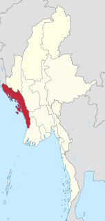
Rakhine State is a state in Myanmar (Burma). Situated on the western coast, it is bordered by Chin State to the north, Magway Region, Bago Region and Ayeyarwady Region to the east, the Bay of Bengal to the west and the Chittagong Division of Bangladesh to the northwest. It is located approximately between latitudes 17°30' north and 21°30' north and longitudes 92°10' east and 94°50' east. The Arakan Mountains or Rakhine Yoma separated Rakhine State from central Burma from North to South. Off the coast of Rakhine State there are some fairly large islands such as Ramree, Cheduba and Myingun. Rakhine State has an area of 36,762 square kilometres (14,194 sq mi) and its capital is Sittwe.

Myanmar is divided into twenty-one administrative subdivisions, which include 7 regions, 7 states, 1 union territory, 1 self-administered division, and 5 self-administered zones. Following is the table of government subdivisions and its organizational structure based on different regions, states, the union territory, the self-administered division, and the self-administered zones:

Mandalay Region is an administrative division of Myanmar. It is located in the center of the country, bordering Sagaing Region and Magway Region to the west, Shan State to the east, and Bago Region and Kayin State to the south. The regional capital is Mandalay. To the south of the region lies the national capital of Naypyidaw. The division consists of eleven districts, which are subdivided into 28 townships and 2,320 wards and village-tracts.

Uthai is a district (amphoe) in the eastern part of Ayutthaya province, in Thailand.

Districts are the second-level administrative divisions of Myanmar. They are the sub-divisions of the States and Regions of Myanmar. According to the Myanmar Information Management Unit (MIMU), as of December 2015, there are 76 districts in Myanmar, which in turn are subdivided into townships, then towns, wards and villages.
Kyaukse District is a district of the Mandalay Region in central Myanmar.

Natogyi is a township of Myingyan District in the Mandalay Division of Burma. The township covers an area of 481.2 square miles (1,246 km2) and as of 2014 it had a population of 196,874 people. In the Myanmar year 763 (1401/02) the settlement was referred to as "Nwa_Dho", derived from nwa (cow) and dho (herd).

Kyonpyaw Township is a township in the northeast of Pathein District in the Ayeyarwady Division of Myanmar. The capital is Kyonpyaw town, founded 600 years ago. The Township borders Lemyethna Township and Hinthada Township of Hinthada District to the north. To the east and southeast it borders Danubyu Township and Pantanaw Township of Maubin District respectively. To the south and west, it borders Kyaunggon Township and Yekyi Township respectively. The Township has a significant Karen population and is divided into 1 town, 4 wards, 89 village tracts and 523 villages.

Mohnyin Township is a township of Mohnyin District in the Kachin State of Burma (Myanmar). The principal town and administrative centre is Mohnyin. Jade and gem quality kyanite are produced in Mohnyin Township, as well as amber, gold, asafoetida, and jasper. Indawgyi Lake Wildlife Sanctuary is located in the central north of the township.

Palaw Township is a township of Myeik District in the Taninthayi Region of Burma (Myanmar). The principal town and administrative seat is Palaw. Second in importance is the town of Palauk.
The Daai are an ethnic group living in Chin State, Myanmar. The Daai consist of 32 Chin tribes, which have been registered by the Government of Burma since 1890. The recent Military Regime’s census mentions the Daai tribe as the 62nd of 135 tribes of Burma. Researchers refer to them as the Daai group in the ethnic survey book of Burma. The Daai Chin appear to be of Mongolian, Indo-Chinese, and Tibeto-Burman descent. The Daai people live in the Mindat, Paletwa, Matupi and Kanpetlet townships of Southern Chin State in Burma. There are more than 180 Daai villages with a total population of somewhere between 40,000 and 50,000. Their population makes the Daai-Chin the majority tribe of the Southern Chin Hills.

Pakokku District is a district of the Magway Division in central Burma (Myanmar). It is situated in northern part of Magwe Region. The administrative centre is the city of Pakokku. Pakokku is a largest city of Magway Division. It is also the 13th largest city of Burma (Myanmar). The townships of Pakokku District are Pakokku, Yesagyo, Pauk, Seikphyu, Myaing, Htilin, Saw and Gangaw.

Hkamti Township or Khamti Township is a township in Hkamti District in the Sagaing Region of Burma (Myanmar). The principal town is Hkamti. As of 2014 the township had a population of 47,658 people and covered an area of 8,174 square kilometres (3,156 sq mi). The township is dominated by the Chindwin River and its tributaries as well as thickly forested areas. Nearly half the active working population are employed in agriculture, forestry or fishing. The township is a producer of rice and has gold and jade reserves.

Twante Township also Twantay Township is a township in the Yangon Region of Burma (Myanmar). It is located west across the Hlaing River from the city of Yangon. The principal town and administrative seat is Twante. The township is home to the Shwesandaw Pagoda and it is believed to contain strands of hair from the head of Gautama, and its annual pagoda festival is held on Burmese New Year. Built by the British in 1881, the Twante Canal The longest man made canal in Myanmar is Twante canal is the longest man-made canal in Myanmar, providing a shortcut waterway between Irawaddy River and Yangon river. This divides Twante Township across its which divides Twante Township with its length of 35 km and there is one bridge that spans the canal is called Twante bridge. Baungdawgyoke Monastery in Twante Township is famous as there are pagodas including the replica of Mahabodhi Temple
Tangsa, also Tase and Tase Naga, is a Sino-Tibetan language or language cluster spoken by the Tangsa people of Burma and north-eastern India. Some varieties, such as Shangge, are likely distinct languages. There are about 60,000 speakers in Burma and 40,000 speakers in India.
Lai-Hka (ဝဵင်းလၢႆးၶႃႈ) is a town of Lai-Hka District in the Shan State of Myanmar. It is the capital of Lai-Hka Township.

Tada-U is the district of Mandalay Region, Myanmar. It's principal town is Tada-U.


