
Takoma Park is a city in Montgomery County, Maryland, United States. It is a suburb of Washington, and part of the Washington metropolitan area. Founded in 1883 and incorporated in 1890, Takoma Park, informally called "Azalea City", is a Tree City USA and a nuclear-free zone. A planned commuter suburb, it is situated along the Metropolitan Branch of the historic Baltimore and Ohio Railroad, just northeast of Washington, D.C., and it shares a border and history with the adjacent Washington, D.C. neighborhood of Takoma. It is governed by an elected mayor and six elected councilmembers, who form the city council, and an appointed city manager, under a council-manager style of government. The city's population was 17,629 at the 2020 census.

Chillum is an unincorporated area and census-designated place in Prince George's County, Maryland, United States, bordering Washington, D.C., and Montgomery County.

Langley Park is an unincorporated area and census-designated place (CDP) in Prince George's County, Maryland, United States. It is located inside the Capital Beltway, on the northwest edge of Prince George's County, bordering Montgomery County. Per the 2020 census, the population was 20,126.

Takoma station is a Washington Metro station on the Red Line in the Takoma neighborhood of Washington, D.C., bordering Takoma Park, Maryland. The station is considered to be located in part of Takoma Park's Historic District. It is the last station in the District of Columbia on the eastern end of the Red Line heading to Maryland, located east of the intersection of Blair Road NW and Cedar Street NW. The station's parking lot and bus stops are accessed from Eastern Avenue NW, which runs along the DC–Maryland line.

Silver Spring station is a train station on the Red Line of the Washington Metro and the Brunswick Line of the MARC Train commuter rail system. The Metro station averaged 4,536 daily riders in 2023, making it the 19th-busiest stop in the network and the busiest in the state of Maryland. Trains travelling south from the station quickly cross the border into Washington, D.C., while northbound trains head underground and make their way further into Montgomery County.
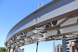
The Purple Line is a 16.2-mile (26.1 km) light rail line being built to link several Maryland suburbs of Washington, D.C.: Bethesda, Silver Spring, College Park, and New Carrollton. Currently slated to open in late 2027, the line will also enable riders to move between the Maryland branches of the Red, Green, and Orange lines of the Washington Metro without riding into central Washington, and between all three lines of the MARC commuter rail system. The project is administered by the Maryland Transit Administration (MTA), an agency of the Maryland Department of Transportation (MDOT), and not the Washington Metropolitan Area Transit Authority (WMATA), which operates Metro.

Maryland Route 193 is a state highway in the U.S. state of Maryland. Known for most of its length as University Boulevard and Greenbelt Road, the state highway runs 26.07 mi (41.96 km) from MD 185 in Kensington east to MD 202 north of Upper Marlboro. MD 193 serves as a major east-west commuter route in eastern Montgomery County and northern Prince George's County, connecting Wheaton, Silver Spring, Langley Park, College Park, and Greenbelt. The state highway also provides the primary access to the University of Maryland and Goddard Space Flight Center. In central Prince George's County, MD 193 is the main north–south highway connecting Glenn Dale and Greater Upper Marlboro with the affluent suburbs of Woodmore and Kettering.

Maryland Route 650 is a state highway in the U.S. state of Maryland. Known as New Hampshire Avenue for most of its length, the state highway runs 25.89 mi (41.67 km) from Eastern Avenue at the Washington, D.C. border north to MD 108 in Etchison. MD 650 serves as a major north-south commuter route in northwestern Prince George's County and eastern Montgomery County, connecting the District of Columbia with the residential suburbs of Takoma Park, Langley Park, Adelphi, Hillandale, White Oak, and Colesville. By contrast, the part of MD 650 north of Spencerville is a quiet rural road connecting several small communities along the northeastern fringe of Montgomery County.
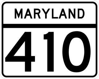
Maryland Route 410 (MD 410) is a state highway in the U.S. state of Maryland and known for most of its length as East–West Highway. The highway runs east to west for 13.92 miles (22.40 km) from MD 355 in Bethesda east to Pennsy Drive in Landover Hills. MD 410 serves as a major east–west commuter route through the inner northern suburbs of Washington, D.C., connecting the commercial districts of Bethesda, Silver Spring, and Hyattsville. In addition, the highway serves the industrial area of Landover Hills and the residential suburbs of Chevy Chase, Takoma Park, Chillum, Riverdale, and East Riverdale. The road also connects many of the arterial highways and freeways that head out of Washington. Additionally, it provides a highway connection to transit and commercial hubs centered around Washington Metro subway stations in Bethesda, Takoma Park, Hyattsville, Silver Spring, and New Carrollton–the latter two of which provide additional connections to MARC and Amtrak trains.

New Hampshire Avenue is a diagonal avenue in Washington, D.C., beginning at the Kennedy Center and extending northeast for about 5 miles (8 km) and then continuing into Maryland, where it is designated Maryland Route 650. New Hampshire Avenue is not contiguous. It stops at 15th and W Streets NW, and resumes again on the other side of Columbia Heights at Park Road NW, a few blocks from Georgia Avenue.
Carole Highlands is an unincorporated community in Prince George's County, Maryland, United States. It is contained between East West Highway to the south, University Boulevard to the north, Larch Avenue, Hopewell Avenue, and 15th Avenue to the west, and Riggs Road to the east. Carole Highlands borders the adjacent neighborhoods of Chillum, Green Meadows, Lewisdale, and Langley Park in Prince George's County, while bordering the city of Takoma Park in Montgomery County. For statistical purposes, it is part of the Langley Park census-designated place (CDP). The community also has a community association and non-profit: Carole Highlands Neighborhood Association

The College Park–Bethesda Line, designated Route J4, was a rush hour-only MetroExtra bus route operated by the Washington Metropolitan Area Transit Authority between the College Park–University of Maryland station of the Green and Yellow Lines of the Washington Metro and Bethesda station of the Red Line of the Washington Metro. The J4 operated throughout the neighborhoods in Prince George's and Montgomery counties in Maryland. This line ran along current construction for the upcoming Purple Line between College Park and Bethesda.

The Riggs Road Line, designated as Routes R1 & R2, is a daily bus route operated by the Washington Metropolitan Area Transit Authority between Fort Totten station of the Red and Green Lines of the Washington Metro & Adelphi (R1) or Calverton (R2). Routes R1 & R2 operate every 20 minutes during peak hours and route R2 operates every 35-60 minutes at other times on weekdays, and 60 minutes on the weekends. R1 trips are roughly 32 minutes and R2 trips are roughly 55 minutes.

The Greenbelt–Twinbrook Line, designated Route C2 or C4, are daily bus routes operated by the Washington Metropolitan Area Transit Authority between Greenbelt station (C2) or Hyattsville Crossing station (C4) of the Green Line and Wheaton station (C2) or Twinbrook station (C4) of the Red Line of the Washington Metro. Both lines operate every 15 – 20 minutes during peak hours, 12 – 24 minutes weekdays and Saturdays, while the C2 runs every 45 – 55 minutes on Sundays and the C4 runs every 12 minutes on Sundays and 30 minutes late nights daily. Trips would take roughly 60 – 70 minutes for both routes. On Sundays however, the C2 is shortened to operate between Takoma Langley Crossroads Transit Center and Greenbelt Station, which takes 30 minutes. Both lines connect northern Prince George's County to Montgomery County via the University Boulevard East/West corridor.

Franklin Knolls is a residential neighborhood located in Silver Spring, a census-designated place in Montgomery County.

The Langley Park–Cheverly Line, designated Route F8, is a daily bus route operated by the Washington Metropolitan Area Transit Authority between the Cheverly Metro station of the Orange Line of the Washington Metro and Takoma – Langley Crossroads Transit Center in Langley Park, Maryland. The line operates every 30–35 minutes during peak hours and every 60–65 minutes at all other times. F8 trips are roughly 54–60 minutes.

The Chillum Road Line, designated as Route F1 is a daily bus route operated by the Washington Metropolitan Area Transit Authority between Cheverly station of the Orange Line of the Washington Metro and Takoma station of the Red Line. The line operates every 25–38 minutes during peak hours, 60 minutes during weekday off peak hours, and 58–62 minutes on the weekends. Trips roughly take 50–60 minutes.

The New Hampshire Avenue–Maryland Line, designated Route K6, is a daily bus route operated by the Washington Metropolitan Area Transit Authority between Fort Totten station on the Red and Green Lines of the Washington Metro and White Oak Shopping Center. The line operates every 12 minutes during most times. Route K6 trips take 28 minutes according to the schedule.

The New Hampshire Avenue–Maryland Limited Line, designated Route K9, is a limited-stop Metrobus route operated by the Washington Metropolitan Area Transit Authority between the Fort Totten station of the Red and Green Lines of the Washington Metro and the Food and Drug Administration in White Oak, Maryland. The line operates every 16-20 minutes during weekday peak-hours only. Route K9 trips are roughly 30 - 35 minutes.
The Twinbrook–Silver Spring Line, designated Route J5, was a bus route operated by the Washington Metropolitan Area Transit Authority between Silver Spring station and Twinbrook station of the Red Line of the Washington Metro. The line operated during the weekday peak-hours only providing express service along the Capital Beltway connecting both Silver Spring and Rockville without having to enter Washington D.C. The line was discontinued on June 25, 2017 due to a budget crisis.

