
Tammela is a municipality of Finland. It is located in the Tavastia Proper region. The municipality has a population of 6,001 and it covers an area of 715.15 square kilometres (276.12 sq mi) of which 74.72 square kilometres (28.85 sq mi) is inland water (2018-01-01). The population density is 9 inhabitants per square kilometre (23/sq mi). The first mention of a village named Tammela was in documents from 1423.

The Battle of Tampere was a 1918 Finnish Civil War battle, fought in Tampere, Finland from 15 March to 6 April between the Whites and the Reds. It is the most famous and the heaviest of all the Finnish Civil War battles. Today it is particularly remembered for its bloody aftermath as the Whites executed hundreds of capitulated Reds and took 11,000 prisoners placed in the Kalevankangas camp.

Tammelan Stadion is a football stadium in Tampere, Finland. The stadium holds 5,050 people and was built in 1931.

Kyttälä is a district in Tampere, Finland. It was born in the late 1870s as a working-class neighborhood to the eastern outskirts of the town. As Tampere soon expanded, Kyttälä is now a part of the city center between the Tammerkoski river and the railway. Population of Kyttälä is 3,348. Aleksanterinkatu is one of Kyttälä's main streets. The direct connection to the Liisankallio district and from there to Teiskontie and Sammonkatu streets runs along Itsenäisyydenkatu and connection to the Jussinkylä district runs along Tuomiokirkonkatu.
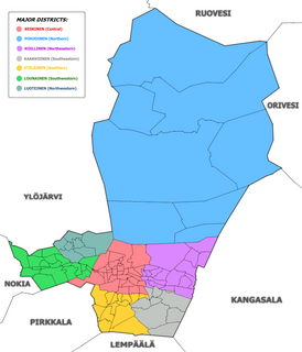
The city of Tampere, the second largest city and urban area of Finland after Helsinki, can be divided into various sorts of subdivisions. The subdivisions include neighbourhoods, districts, major districts and postal code areas. The plethora of different official ways to divide the city is a source of some confusion to the inhabitants, as different kinds of subdivisions often share similar or identical names.

Tampella is a neighbourhood in the northern part of the city center of Tampere, Finland. It consists of the old Tampella factory area, the Armonkallio residential area and the Naistenlahti harbor area. The neighboring parts of the internally heterogeneous district located on the shores of Lake Näsijärvi are Lapinniemi, Lappi, Osmonmäki, Tammela, Jussinkylä, Finlayson and Särkänniemi.
Jussinkylä is a neighbourhood in the city center of Tampere, Finland. It is located east of Tammerkoski and borders Satakunnankatu in the south. To the east and northeast, the district is bounded by a railway and to the northwest by Lapintie. The Erkkilä Bridge connects Jussinkylä to Tammela. The most significant landmarks in the area are Tampere Cathedral and Tampere Central Fire Station. Neighboring neighborhoods are Finlayson, Tampella and Kyttälä, from which the latter runs a route along the Tuomiokirkonkatu street.

Kalevanrinne is a district of Tampere, Finland. It is located in the Sampo area between the districts of Kaleva and Järvensivu, bordering Liisankallio and Kalevanharju in the west, Hakametsä and Vuohenoja in the east. The city plan of Kalevanrinne was confirmed in 1951 and supplemented in 1955 and 1960. Kalevanrinne has a hypermarket Prisma, a pet store Musti ja Mirri and a electronics store Gigantti. There are also 13 planned apartment buildings in the area, which means that the Kalevanrinne residential area, located between Kalevantie and Sammonkatu, is planned to have about 1,360 inhabitants. The planned area is about 3,5 hectares in size.

Liisankallio is a district of Tampere, Finland. The district, formerly known as Tammelan vainio, is located east of the Tammela and Tulli districts. To the north is the Petsamo district, to the east are Kaleva and Kalevanrinne, to the south is Kalevanharju. When we often talk about Kaleva, we mean a larger entity formed by Liisankallio, Kaleva and Kalevanrinne.

Keskusta is a main district of the city of Tampere, Finland, formed by less than 20 suburbs in the city centre. Over 63,000 people live in Keskusta. It is located along the Tammerkoski rapids and its most important services include Tampere City Hall and the Market Hall.

Osmonmäki is a district in the center of Tampere, Finland. The immediate neighbors of the area are Tammela, Tampella, Lappi and Petsamo. There are apartment buildings in the area, but also hundred-year-old wooden buildings. In 2011, the district had 1,613 inhabitants.

Itsenäisyydenkatu is an east–west street in the center of Tampere, Finland. It is a significant street connection in the city center of Tampere in terms of transport connections, as it leads from Tampere's railway station to the Liisankallio district in the Tammela district. On the west side of the station, the street continues as the Hämeenkatu street, at its eastern end it meets Kalevan puistokatu, branching into Teiskontie and Sammonkatu. Today, the only crossroads on Itsenäisyydenkatu with cross-street vehicle traffic is Tammelan puistokatu–Yliopistonkatu.

Tammelantori is a market square in the Tammela district in the center of Tampere in Pirkanmaa, Finland. It is one of Tampere's most significant marketplaces, which is very popular, especially during the summer. The market is very famous for its cafes and mustamakkara kiosks.

Rautaharkko is a district of Tampere, Finland, located about three kilometers from the its city center. Rautaharkko is bordered on the west by Rantaperkiö, on the east by Taatala and Nirva, on the south by Lakalaiva and on the north by Vihioja and Hatanpää. As of 31 December 2014, Rautaharkko had 533 inhabitants.
Nurmi is a statistical area of Tampere, Finland, located about ten kilometers northeast of the city center. Nurmi is bordered on the west by Lake Näsijärvi, on the east by the Kangasala town, on the south by Olkahinen and on the north by Sorila and Aitoniemi. At the end of 2014, Nurmi had 360 inhabitants. Until 1965, Nurmi belonged to the municipality of Aitolahti before the municipality was incorporated into Tampere. Initially, Nurmi also formed its own urban area, but today it has merged into the Tampere urban area.

Haihara is a small district in Tampere, Finland, located about seven kilometers from the city center. Haihara is bordered on the south by Kaukajärvi, on the west by Viiala and on the north by Hankkio. In 2014, Haihara had 199 inhabitants. After Kämmenniemi and Korkinmäki, Haihara had the relatively highest number of school-age children in the districts of Tampere in 2014. Despite its name, the Haihara Manor and Haihara Art Center are not in Haihara, but are located on the Kaukajärvi side.

Petsamo is a district of Tampere, Finland. The district is named after the Pechengsky, which Finland was acquired in connection with the Treaty of Tartu. At the same time as Soviet Russia ceded Pechengsky to Finland in 1920, some large Tamperean industrial plants began to build a residential area for their working population on the northeast corner of the city. When the area seemed to be far from the center, the informal name of the district was born as a result of the image.

Lapinniemi is a district in the northern part of Tampere, Finland. It is located on a peninsula formed on the shores of Lake Näsijärvi. Neighboring parts of the city are Petsamo, Lappi and Tampella. It is about a kilometer from the city center of Tampere to Lapinniemi, but it takes about five minutes by bus through Tammela and 10 minutes to the Central Square.

Epilä is a district in Tampere, Finland. The area is bordered on the north by the Tampere–Pori railway and Lielahti, on the east by Hyhky's Vaakonkatu, on the west by Rahola and on the south by Kaarila.

