Tampere is a city in Pirkanmaa in the western part of Finland. Tampere is the most populous inland city in the Nordic countries; it has a population of 238,140 with the urban area holding 334,112 people and the metropolitan area, also known as the Tampere sub-region, holding 385,301 inhabitants in an area of 4,970 km2 (1,920 sq mi). Tampere is the second-largest urban area and third most-populous individual municipality in Finland, after the cities of Helsinki and Espoo and the most populous Finnish city outside the Greater Helsinki area, within which both Helsinki and Espoo are located. Today, Tampere is one of the major urban, economic, and cultural hubs in the whole inland region.

Pirkkala is a municipality of Finland. It is located some 10 kilometres (6 mi) south-west from Tampere in the Pirkanmaa region. The municipality has a population of 19,904 and covers an area of 104.04 square kilometres (40.17 sq mi) of which 22.66 km2 (8.75 sq mi) is water. The population density is 244.58 inhabitants per square kilometre (633.5/sq mi), which make it the most densely populated municipality in Finland, which does not use the title of town or city. Also, Pirkkala is currently the fastest-growing municipality in the Pirkanmaa region. The municipality is unilingually Finnish.
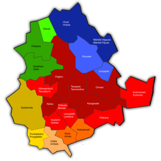
Pirkanmaa, also known as Tampere Region in government documents, is a region of Finland. It borders the regions of Satakunta, South Ostrobothnia, Central Finland, Päijät-Häme, Kanta-Häme and Southwest Finland. Most of the water area in the Kokemäki River watershed is located in the Pirkanmaa region, although Lake Vanajavesi is partly in the Kanta-Häme region. The region got its name from Pirkkala, which in the Middle Ages comprised most of present-day Pirkanmaa. Tampere is the regional center and capital of Pirkanmaa, and at the same time the largest city in the region.

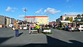
Mustamakkara is a type of Finnish blood sausage traditionally eaten with lingonberry jam. It is nowadays available in many stores across Finland, but is held in the position of local delicacy and speciality of Tampere, Pirkanmaa. Mustamakkara is at its best when bought and eaten fresh at market stalls, to which it is delivered hot in styrofoam boxes from the factories directly after baking. A typical practice of reheating the sausage is to just fry it in a pan.
Ideapark is a shopping mall in Lempäälä, Finland. It is notable for being very large by Nordic standards. The mall was built on a greenfield site alongside the Helsinki–Tampere Highway (E12) approximately twelve kilometres south of Tampere, the capital of the Pirkanmaa region, and Tampere Airport in Pirkkala is about a 20-minute drive from Ideapark.

Tampere University of Applied Sciences is a university of applied sciences in the region of Pirkanmaa, Finland. Together with Tampere University, TAMK constitutes the Tampere higher education community.
Tammela is a district in Tampere, Finland, located east of the city centre. Tammela was born since the 1870s as a working-class neighbourhood, today it is especially popular among the students of the nearby Tampere University. Population of Tammela is 5,646.
Teiskontie is a street and highway in Tampere, Finland. As its name implies, it runs from the center of Tampere towards Teisko, a former municipality connected to Tampere in 1972. To the east of the highway junction of Hervanta, it is part of Highway 12 leading in the direction of Lahti and Kouvola. On the east side of Lake Alasjärvi, Teiskontie has a connection to Highway 9 (E63) leading in the direction of Jyväskylä and Kuopio.

Keskusta is a main district of the city of Tampere, Finland, formed by less than 20 suburbs in the city centre. Over 63,000 people live in Keskusta. It is located along the Tammerkoski rapids and its most important services include Tampere City Hall and the Market Hall.

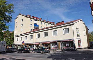
Osmonmäki is a district in the center of Tampere, Finland. The immediate neighbors of the area are Tammela, Tampella, Lappi and Petsamo. There are apartment buildings in the area, but also hundred-year-old wooden buildings. In 2011, the district had 1,613 inhabitants.

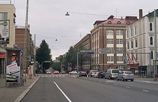
Itsenäisyydenkatu is an east-west street in the center of Tampere, Finland. It is a significant street connection in the city center of Tampere in terms of transport connections, as it leads from Tampere's railway station to the Liisankallio district in the Tammela district. On the west side of the station, the street continues as the Hämeenkatu street, at its eastern end it meets Kalevan puistokatu, branching into Teiskontie and Sammonkatu. Today, the only crossroads on Itsenäisyydenkatu with cross-street vehicle traffic is Tammelan puistokatu–Yliopistonkatu.

Hervantajärvi is the southernmost district of the Tampere city in Pirkanmaa, Finland, located about eight kilometers southeast of the city center. It is bordered on the west by Vuores and on the north by Ruskontie, on the north by Hervanta and Rusko. In the east the border is between Kangasala and in the south against Lempäälä. The district is named after Lake Hervanta in the area, which is partly on the Lempäälä side.

Kämmenniemi is a district, a statistical area and an urban area of Tampere, Finland, located in the area of the former municipality of Teisko. The regional road 338 between Tampere and Ruovesi runs through Kämmenniemi. The distance from the village to the city center of Tampere is about 25 kilometers. The most important sights and buildings in Kämmenniemi are, for example, the Aunessilta arch bridge and Kämmenniemi School. Among other things, the annual Teisko market is organized in Kämmenniemi. Kämmenniemi also has a library and fire station of the Teisko's volunteer fire department. The Paarlahti bay is also located in Kämmenniemi, which is called the only fjord in Finland; however, according to official definitions, it does not quite meet the characteristics of a fjord.

Vuores is an area located on the border of Tampere and Lempäälä in the Pirkanmaa region, Finland. Each municipality is building in its own area, but a partial master plan has been drawn up in co-operation. On the Tampere side, construction began in 2010. The area is diverse in terms of terrain and nature, and there are numerous lakes. In the 2019 agglomeration delimitation, Vuores formed its own urban area with an area of 3,03 km2. The urban area had 5,355 inhabitants and was the second most densely populated urban area in Finland with a population density of 1,767 inhabitants/km2.

Lentävänniemi is a district in the western part of Tampere on the shores of Lake Näsijärvi in Pirkanmaa, Finland. It belongs to the northwestern part of the city and borders the Niemi and Niemenranta borders on the southwest. There are jogging paths along the lake and its shores surrounding the apartment-based Lentävänniemi. In 2014, the population of Lentävänniemi was 4,309.
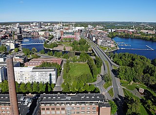
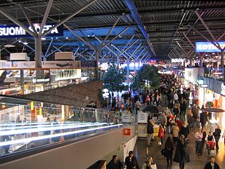
Ratina is a district in the center of Tampere, Finland, on the east side of Tammerkoski. The Ratina Stadium, Tampere Bus Station and Tampere's largest shopping mall, the Ratina shopping centre, are located in the district, among others. To the north of Ratina is also the Koskikeskus shopping centre. The district consists of a peninsula called Ratinanniemi, which is surrounded on three sides by Ratinansuvanto and Viinikanlahti. Between Ratinanniemi and the Laukontori square is a pedestrian bridge called Laukonsilta, which significantly shortens travel time to the city center. The Tampere highway has good connections to the Helsinki-Tampere motorway and along it to the Tampere Ring Road, and via the Ratinansilta bridge and the Hämeenpuisto park to Highway 12. Ratinanranta is the southern part of the Tampere highway from Ratina, which used to be a recreation ground and factory area. Its new construction into a dense apartment building area of 1,000 inhabitants began in 2008, and the latest residential buildings east of the Voimakatu street are expected to be completed in 2013.

Laukontori is a market square in the southern part of the city center of Tampere, Finland, on the shores of Lake Pyhäjärvi. It is located just a few hundred meters from Tampere Central Square. Square's beach serves as a harbor for cruise ships to the Viikinsaari island and the city of Hämeenlinna in the summer.

Tuomiokirkonkatu is a north-south street located in the center of Tampere, Finland, which runs through the districts of Jussinkylä and Kyttälä. The street is about a kilometer long. In the north it ends at Lapintie, in the south Vuolteenkatu. In Kyttälä, part of Tuomiokirkonkatu has been turned into a pedestrian street. In the future, the pedestrian section will be expanded so that it will eventually extend south from Kyttälänkatu to Suvantokatu and the Sori Square.

Kissanmaa is a district in the eastern part of Tampere, Finland, along the Teiskontie street. It belongs to the subdivision of Sampo, and it is located 3 kilometers from the city center. Kissanmaa is surrounded by Ruotula and Uusikylä in the east, Hakametsä in the south, Kaleva in the west and Kauppi in the north. Most of the residential houses are detached houses, but there are also apartment buildings of different sizes in the western part of the area. The area is best known for Finland's first ice rink, Tampere Ice Stadium, and training hall, completed in 1965. The first town plan of Kissanmaa was established in 1958.
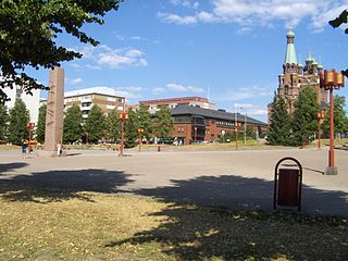
The Sori Square is a square located in the center of Tampere, Finland, in the southern part of the Kyttälä district. It is located in the area bounded by the Hatanpää Highway, Suvantokatu, Tuomiokirkonkatu and Vuolteenkatu. At the eastern end of the square is the Tampere Orthodox Church from 1898. There is a terminus at Tampere Tram Line 1 on the west side.