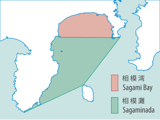
Sagami Bay lies south of Kanagawa Prefecture in Honshu, central Japan, contained within the scope of the Miura Peninsula, in Kanagawa, to the east, the Izu Peninsula, in Shizuoka Prefecture, to the west, and the Shōnan coastline to the north, while the island of Izu Ōshima marks the southern extent of the bay. It lies approximately 40 kilometres (25 mi) southwest of the capital, Tokyo. Cities on the bay include Odawara, Chigasaki, Fujisawa, Hiratsuka, Itō, and Kamakura.
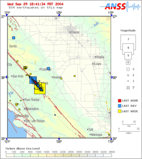
Parkfield earthquake is a name given to various large earthquakes that occurred in the vicinity of the town of Parkfield, California, United States. The San Andreas fault runs through this town, and six successive magnitude 6 earthquakes occurred on the fault at unusually regular intervals, between 12 and 32 years apart, between 1857 and 1966. The most recent significant earthquake to occur here happened on September 28, 2004.

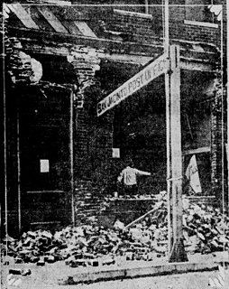
The 1886 Charleston earthquake occurred about 9:50 p.m. local time August 31 with an estimated moment magnitude of 6.9–7.3 and a maximum Mercalli intensity of X (Extreme). The intraplate earthquake caused 60 deaths and between $5 million and $6 million in damage to 2,000 buildings in the Southeastern United States. It is one of the most powerful and damaging earthquakes to hit the East Coast of the United States. Very little to no historical earthquake activity had occurred, which is unusual for any seismic area.

The Newport–Inglewood Fault is a right-lateral strike-slip fault in Southern California. The fault extends for 47 miles (76 km) from Culver City southeast through Inglewood and other coastal communities to Newport Beach at which point the fault extends east-southeast into the Pacific Ocean where it is known as the Rose Canyon Fault. The fault can be inferred on the Earth's surface as passing along and through a line of hills extending from Signal Hill to Culver City. The fault has a slip rate of approximately 0.6 millimeter/year (0.02 in/year) and is predicted to be capable of a 6.0–7.4 magnitude earthquake on the moment magnitude scale. A 2017 study concluded that, together, the Newport–Inglewood Fault and Rose Canyon Fault could produce an earthquake of 7.3 or 7.4 magnitude.
The 1891 Mino–Owari earthquake struck the former Japanese provinces of Mino and Owari in the Nōbi Plain in the early morning of October 28 with a surface wave magnitude of 8.0. The event, also referred to as the Nōbi earthquake or the Great Nōbi earthquake, is the strongest known inland earthquake to have occurred in the Japanese archipelago.

The 1703 Genroku earthquake occurred at 02:00 local time on December 31. The epicenter was near Edo, the forerunner of present-day Tokyo, in the southern part of the Kantō region, Japan. An estimated 2,300 people were killed by the shaking and subsequent fires. The earthquake triggered a major tsunami which caused many casualties, giving a total death toll of at least 5,233, possibly up to 10,000. Genroku is a Japanese era spanning from 1688 through 1704.

The Dasht-e Bayaz and Ferdows earthquakes occurred in Dashte Bayaz, Kakhk and Ferdows, Iran in late August and early September 1968. The mainshock measured 7.4 on the moment magnitude scale and had a maximum perceived intensity of X (Extreme) on the Mercalli intensity scale. Damage was heavy in the affected areas with thousands of lives lost in the first event and many hundreds more in the second strong event.

The 2002 Denali earthquake occurred at 22:12:41 UTC November 3 with an epicenter 66 km ESE of Denali National Park, Alaska, United States. This 7.9 Mw earthquake was the largest recorded in the United States in 37 years. The shock was the strongest ever recorded in the interior of Alaska. Due to the remote location, there were no fatalities and only a few injuries.

The 1868 Hayward earthquake occurred in the San Francisco Bay Area, California, United States on October 21. With an estimated moment magnitude of 6.3–6.7 and a maximum Mercalli intensity of IX (Violent), it was the most recent large earthquake to occur on the Hayward Fault Zone. It caused significant damage and a number of deaths throughout the region, and was known as the "Great San Francisco earthquake" prior to the 1906 San Francisco earthquake and fire.
The Hosgri Fault is an offshore fault zone located near the Central Coast of California in San Luis Obispo County. The main fault stretches for about 87 miles (140 km), and is located nearest to the coastal communities of Cambria, San Simeon, Morro Bay, Baywood Park-Los Osos and Avila Beach. The fault system is some 260 mi (420 km) long, and is a right-lateral strand of the San Andreas Fault system.

The 1906 Ecuador–Colombia earthquake occurred at 15:36 UTC on January 31, off the coast of Ecuador, near Esmeraldas. The earthquake had a moment magnitude of 8.8 and triggered a destructive tsunami that caused at least 500 casualties on the coast of Colombia.
The 1940 El Centro earthquake occurred at 21:35 Pacific Standard Time on May 18 in the Imperial Valley in southeastern Southern California near the international border of the United States and Mexico. It had a moment magnitude of 6.9 and a maximum perceived intensity of X (Extreme) on the Mercalli intensity scale. It was the first major earthquake to be recorded by a strong-motion seismograph located next to a fault rupture. The earthquake was characterized as a typical moderate-sized destructive event with a complex energy release signature. It was the strongest recorded earthquake to hit the Imperial Valley, and caused widespread damage to irrigation systems and led to the deaths of nine people.
The 1944 Tōnankai earthquake occurred at 13:35 local time on 7 December. It had an estimated magnitude of 8.1 on the moment magnitude scale and a maximum felt intensity of greater than 5 shindo. It triggered a large tsunami that caused serious damage along the coast of Wakayama Prefecture and the Tōkai region. Together the earthquake and tsunami caused 3,358 casualties.
The 1974 Izu Peninsula earthquake occurred on May 9 at 08:33 local time. The epicenter was located off the Izu Peninsula, Japan. 25 people were reported dead. Landslides and damage of roads, buildings, and infrastructure were reported. This earthquake triggered a small tsunami. The intensity in Tokyo reached shindo 3. The magnitude of this earthquake was put at Ms 6.5, or MJMA 6.9.

The 1943 Alahan Panjang earthquakes occurred on June 8 and June 9 UTC in Sumatra, then under Japanese occupation. This was an earthquake doublet.

The 1906 Aleutian Islands earthquake occurred at 00:11 UTC on August 17. It had an estimated seismic moment of 3.8 x 1028 dyn cm−1, equivalent to a magnitude of 8.35 on the moment magnitude scale. This earthquake was followed thirty minutes later by the 1906 Valparaíso earthquake in Chile, but the two events are not thought to be linked. Due to the remote location, there are no reports of damage associated with this earthquake. A transpacific tsunami reported from Japan and Hawaii was triggered by the Chilean event, rather than the Aleutian Islands earthquake.

The 1931 Myitkyina earthquake, or also known as the 1931 Kamaing earthquake, occurred on January 28 at 02:35 local time. It was located in northern Burma, then part of British India. The magnitude of this earthquake was put at Mw 7.6. According to some sources the depth was 35 km, and according to a study of Phyo M. M. the depth was 5 to 30 km.
The 1918 San Jacinto earthquake occurred in extreme eastern San Diego County in Southern California on April 21 at 14:32:29 local time. The shock had a moment magnitude of 6.7 and a maximum Mercalli intensity of IX (Violent). Several injuries and one death occurred with total losses estimated to be $200,000.
The 1847 Nagano earthquake occurred at about 21:30 local time on 8 May. It had a magnitude of 7.4 on the surface wave magnitude scale. It caused the destruction of many houses in Nagano and at least 8,600 people were killed. The earthquake triggered many landslides, the largest of which dammed the Sai River. 19 days later, the failure of this earthquake dam caused a flood that destroyed many more houses and killed a further 35 people.


