
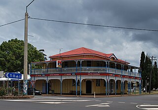
Yarraman is a rural town and locality in the Toowoomba Region, Queensland, Australia. In the 2021 census, the locality of Yarraman had a population of 1,127 people.

Nanango is a rural town and locality in the South Burnett Region, Queensland, Australia. In the 2021 census, the locality of Nanango had a population of 3,679 people.
Blackbutt is a rural town and locality in the South Burnett Region, Queensland, Australia. In the 2021 census, the locality of Blackbutt had a population of 799 people.

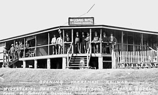
The Brisbane Valley railway line was a railway connection in Queensland, Australia connecting Ipswich, west of Brisbane, to the upper Brisbane River valley. Progressively opened between 1884 and 1913, the railway provided a vital transport link between Ipswich and Yarraman and forged development and prosperity along its path. The line acquired its serpentine reputation because it did not take a straight course when faced with a hill or gully.

Moore is a rural town and locality in the Somerset Region, Queensland, Australia. In the 2021 census, the locality of Moore had a population of 286 people.

Benarkin is a rural town and locality in the South Burnett Region, Queensland, Australia. The nearby town of Blackbutt is the origin of the town and the two towns are often referred to as the joint entity Blackbutt-Benarkin. In the 2021 census, the locality of Benarkin had a population of 61 people.

Colinton is a rural locality in the Somerset Region, Queensland, Australia. In the 2021 census, Colinton had a population of 60 people.
Upper Yarraman is a rural locality in the Toowoomba Region, Queensland, Australia. In the 2021 census, Upper Yarraman had a population of 80 people.
Nukku is a rural locality in the South Burnett Region, Queensland, Australia. In the 2021 census, Nukku had a population of 40 people.
Benarkin North is a rural locality in the South Burnett Region, Queensland, Australia. In the 2021 census, Benarkin North had a population of 341 people.
Mount Stanley is a rural locality in the Somerset Region, Queensland, Australia. In the 2021 census, Mount Stanley had a population of 11 people.
Blackbutt North is a rural locality in the South Burnett Region, Queensland, Australia. In the 2021 census, Blackbutt North had a population of 451 people.

Blackbutt South is a rural locality in the South Burnett Region, Queensland, Australia. In the 2021 census, Blackbutt South had a population of 160 people.
Gilla is a rural locality in the Toowoomba Region, Queensland, Australia. In the 2021 census, Gilla had a population of 61 people.
Googa Creek is a rural locality in the Toowoomba Region, Queensland, Australia. In the 2021 census, Googa Creek had a population of 54 people.
South Nanango is a rural locality in the South Burnett Region, Queensland, Australia. In the 2021 census, South Nanango had a population of 893 people.

East Nanango is a rural locality in the South Burnett Region, Queensland, Australia. In the 2021 census, East Nanango had a population of 273 people.
Glan Devon is a rural locality in the South Burnett Region, Queensland, Australia. In the 2021 census, Glan Devon had a population of 219 people.

South East Nanango is a rural locality in the South Burnett Region, Queensland, Australia. In the 2021 census, South East Nanango had a population of 344 people.
Emu Creek is a rural locality in the Toowoomba Region, Queensland, Australia. In the 2021 census, Emu Creek had a population of 113 people.
