Tassinong, Indiana

Last updated
Tassinong, Indiana
Porter County Indiana and Tassinong.PNG
Map of Porter County, Indiana with an inset showing the location of the community of Tassinong
Coordinates: 41°20′0.981″N87°1′0.674″W / 41.33360583°N 87.01685389°W / 41.33360583; -87.01685389 Coordinates: 41°20′0.981″N87°1′0.674″W / 41.33360583°N 87.01685389°W / 41.33360583; -87.01685389
Country United States
State Indiana
County Porter
Township Morgan
Area
  Total0.1 sq mi (0.026 km2)
  Land0.1 sq mi (0.026 km2)
  Water0.0 sq mi (0.0 km2)
Elevation
695 ft (211.8 m)
Population
 (2010)
  Total15
Time zone UTC-6 (CST)
  Summer (DST) UTC-5 (CDT)
ZIP code
46302
Area code(s) 219

Tassinong is an unincorporated rural community in Porter County, Indiana, south of the city of Valparaiso. The community includes an historic marker claiming it to be a French mission and trading post in 1673, which would make it the oldest European settlement in Indiana as well as in neighboring Illinois.

Contents

History

The first use of the word Tassinong appears in 1830, referring to a village of Potawatomi Indians. [1] The earlier existence of an Indian village and a French trading post are identified by an historic marker in Tassinong. The earliest presence of Europeans in the Porter County area is in 1679, when Sieur de La Salle passed down the Kankakee River, 7 miles (11 km) to the south. [2] At that time, the area south of Lake Michigan was embroiled in the Beaver Wars, which began in the Iroquois lands of New York in 1638. Iroquois war parties had destroyed the Erie Nation by 1656 [3] and had moved west into the western Great Lakes by 1670 [4]

In 1689, the Miami, with aid from the Anishinaabe Confederacy (Odawa, Potawatomi, and Ojibwa) defeated the Iroquois near modern South Bend. [5] That began a return migration of Potawatomi peoples to the lands around the St. Joseph River with over 200 warriors and their families coming to the St. Joseph valley by 1695. [6] The arrival of a settlement occurred in 1834, four years existence of a Potawatomi village. The village may have taken its name from the nearby woodlands, Tassinong Grove. A post office began operations at Tassinong Grove on April 10, 1838. [7] Tassinong Grove was located two miles (3.2 km) south of the community of Tassinong. [8] By 1846, the community and post office had moved north to the location where the Baum’s Bridge Road joined the road to Valparaiso, modern Indiana State Road 49. In that year, several businesses are listed, including two stores, two blacksmiths, a carpenter, a tavern and a shoemaker. A church was built in 1855 by the Presbyterians. [9] The decline of the village began in 1865 when the Pittsburgh, Cincinnati and St. Louis Railroad was built through Kouts, two miles (3.2 km) to the south. [10]

Photograph of the area of the community of Tassinong Tassinong area - Baums Bridge Rd, looking south.jpg
Photograph of the area of the community of Tassinong

Location

The location of Tassinong first appeared on a map in 1875, when the state of Indiana completed its survey of Morgan and Pleasant townships in Porter County. A trail is shown leading from the Potawatomi Ford at modern Baum’s Bridge along the Baum’s Bridge Road to the area of Tassinong, [11] then heading north towards Valparaiso. [12] The oldest available Atlas of Porter County, 1876, shows the village of Tassinong in the southeast quarter of Section 31, Township 34, Range 5. [13]

Schools

Tassinong is in East Porter County School Corporation. The high school is Morgan Township High School, located north of Malden on State Route 49.

Transportation

State Route 49 goes north past Valparaiso to end at the Indiana Dunes State Park on Lake Michigan and south to State Route 14 in central Jasper County.

Controversy

On June 13, 1960, a brass plaque was unveiled in Tassinong to commemorate the long history of the site. The marker reads, Oldest Village in Northern Indiana * A French mission and Trading Post – 1673 - Post Office Established – 1837 * John Jones, P.M. * Incorporated as a Village 1852 by Joseph Bartholomew and Jesse Spencer. It was created and placed through the efforts of the historical society of Porter County, Duneland Historical Society. The controversy revolves around the 1673 date for a French mission and trading post. No documentation has been found that predates 1915.

Scanned copy of the original 1875 Indiana Survey of Porter County, Morgan Township, T34, R5. 1875 Survey T34 R5.JPG
Scanned copy of the original 1875 Indiana Survey of Porter County, Morgan Township, T34, R5.

In 1915, Hubert Skinner, then president of the Porter County Historical Society, wrote an article in the Indiana Magazine of History , showing the origin of the word Tassinong from the French word Tassement. [14] In the following issue, P. Dunn of Indiana University, Bloomington, refuted the assertion that Tassinong could be derived from Tassement. [15] The implication of the Skinner article was conclusive proof that they (the local Indians) derived the word from the French and passed it on, establishing a French presence at that location. [14] Skinner wrote a counter rebutal afterwards and nothing further was heard.

In 1934, A.J. Bowser wrote Tasssinong and Kouts for the local newspaper. Here he introduced the name Bengal as a prior name for the area, while supporting the Dunn argument that there is no proof of a French connection. [16] The Kouts High School History of Pleasant Township was published in the local paper in 1936, establishing the presence of Claude-Jean Allouez, Claude Dablon, Father Jacques Marquette, and René-Robert Cavelier, Sieur de La Salle in Porter County, passing "through this territory on foot". [17] No mention of Tassinong for any French post was made.

The Stroller was a local columnist during the 1950s and 1960s who wrote extensively in the newspaper about Porter County and its history. In 1957, he picked up the story of Tassinong. He identified that Fathers Allouez, Chardon, and D’Ablon (Dablon) preached at Tassinong and that, in 1875, Sylvester Pierre, the Tassinong postmaster provided an extensive history for the village, including that it was originally called Sequada Tiera by the Spanish, and then Haute Terre by the French. By 1700, it was Tassament de Benevole, becoming Benevole in 1763 when the English occupied the site. Then, in 1781, it appeared as Tassnaugh. [18] He further wrote that the French post was burned in the 1700s by the English and had also been conquered by the Spanish for two weeks sometime in the 1700s. Specific dates were not given. He confirmed the return of the Potawatomi in the early 1800s and establishment of the first store in 1846.

The interest in Tassinong continued in 1959, when the Porter County Historical Society began discussions about placing an historic marker at the site. According to a newspaper article by Henry Rankin (reported living in 1882), the history of the site included:

Based on this evidence, the brass historic marker was erected at Tassinong, commemorating the 200 year history.

Related Research Articles

Berrien County, Michigan U.S. county in Michigan

Berrien County is a county on the south line of Michigan, at the southwestern corner of the state. As of the 2010 census, the population was 156,813. The county seat is St. Joseph.

Porter County, Indiana U.S. county in Indiana

Porter County is a county in the U.S. state of Indiana. As of 2010, the population was 164,343. The county seat is Valparaiso. The county is part of Northwest Indiana, as well as the Chicago metropolitan area. Porter County is the site of much of the Indiana Dunes, an area of ecological significance. The Hour Glass Museum in Ogden Dunes documents the region's ecological significance.

Potawatomi Native American people of the Great Plains

The Potawatomi, also spelled Pottawatomi and Pottawatomie, are a Native American people of the Great Plains, upper Mississippi River, and western Great Lakes region. They traditionally speak the Potawatomi language, a member of the Algonquin family. The Potawatomi call themselves Neshnabé, a cognate of the word Anishinaabe. The Potawatomi are part of a long-term alliance, called the Council of Three Fires, with the Ojibway and Odawa (Ottawa). In the Council of Three Fires, the Potawatomi are considered the "youngest brother" and are referred to in this context as Bodéwadmi, a name that means "keepers of the fire" and refers to the council fire of three peoples.

Watseka or Watchekee was a Potawatomi Native American woman, born in Illinois, and named for the heroine of a Potawatomi legend. Her uncle was Tamin, the chief of the Kankakee Potawatomi Indians.

Earl Landgrebe American politician

Earl Fredrick Landgrebe was an American politician and businessman who served as a Republican senator in the Indiana Senate and member of the United States House of Representatives. During the Watergate scandal he defended President Richard Nixon, which cost him his seat in the 1974 congressional election.

The Calumet Region is the geographic area drained by the Grand Calumet River and the Little Calumet River of northeastern Illinois and northwestern Indiana in the United States. It is part of the Great Lakes Basin, which eventually reaches the Atlantic Ocean. It is a sub-region of the greater Northwest Indiana region and the even larger Great Lakes region.

Indiana State Road 49

State Road 49 (SR 49) is a 44.15-mile (71.05 km), north–south state highway in the northwestern part of the U.S. state of Indiana. Its northern terminus is at an intersection with U.S. Route 12 in Porter near the entrance to Indiana Dunes State Park. The southern terminus is a rural intersection with State Road 14 in Barkley Township at Lewiston, 10 miles (16 km) northeast of Rensselaer.

Joseph Bailly was a fur trader and a member of an important French Canadian family that included his uncle, Charles-François Bailly de Messein.

Potawatomi Trail of Death Forced removal by militia in 1838 of members of the Potawatomi nation from Indiana

The Potawatomi Trail of Death was the forced removal by militia in 1838 of some 859 members of the Potawatomi nation from Indiana to reservation lands in what is now eastern Kansas. The march began at Twin Lakes, Indiana on November 4, 1838, along the western bank of the Osage River, near present-day Osawatomie, Kansas. During the journey of approximately 660 miles (1,060 km) over 61 days, more than 40 persons died, most of them children. It marked the single largest Indian removal in Indiana history.

Shabbona

Shabbona, also known as Shabonee and Shaubena, was an Ottawa tribe member who became a chief within the Potawatomi tribe in Illinois during the 19th century.

Westchester Township, Porter County, Indiana Township in Indiana, United States

Westchester Township is one of twelve townships in Porter County, Indiana. It is included in the Calumet, Northwest Indiana, and Great Lakes regions. It is located on the southern shore of Lake Michigan, about 50 miles (80 km) southeast of Chicago. It stretches from the famous Indiana Dunes on its northern border, south to the Valparaiso Moraine, a ridge of rolling hills left by the last glacier to pass through the area. As of the 2010 census, its population was 19,396.

The Indiana Dunes are natural sand dunes occurring at the southern end of Lake Michigan in the American State of Indiana. They are known for their ecological significance. Many conservationists have played a role in preserving parts of the Indiana Dunes. The Hour Glass, a museum in Ogden Dunes, showcases some of the ecological import of the Dunes.

The lost towns are a group of places that are still commonly used by county residents. Each was at one time a post office, a store that served a part of the county, a grain elevator used by farmers to ship their crops, or a development that was or may still remain a unique designation. There may be a residential association or some other legal body devoted to the area. More often, these communities are communities of people who still refer to their homes by these geographic designations.

Salt Creek (Little Calumet River tributary)

Salt Creek is a 24.0-mile-long (38.6 km) tributary of the East Arm Little Calumet River that begins south of Valparaiso in Porter County, Indiana and flows north until it joins the East Arm Little Calumet River just before it exits to Lake Michigan via the Port of Indiana-Burns Waterway.

City West, Indiana

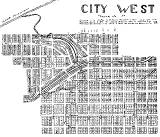
City West was a village in Porter County, Indiana, USA, located on the shore of Lake Michigan approximately 10 miles west of Michigan City, Indiana. It was situated near the mouth of Fort Creek, now known as Dunes Creek, which empties into Lake Michigan near the Indiana Dunes State Park swimming beach. It was located near the former site of Petit Fort.

Charles F. Lembke was an American architect and contractor who was prominent in Valparaiso, Indiana. Lembke built many downtown Valparaiso-area buildings, such as the Memorial Opera House, Carnegie public Library, Hotel Lembke, and several local schools.

Michael Jerome Aylesworth is an American politician who is a current member of the Indiana House of Representatives. A member of the Republican Party, Aylesworth was elected to the Indiana House on November 4, 2014 and was subsequently sworn in on November 19 of that year. Elected to represent the 11th district, Aylesworth's district represents southern Lake and Porter County.

The Lake-Porter County Conference was an IHSAA-sanctioned conference in Northwest Indiana. The conference formed by 1929 at latest, consisting of smaller schools in Lake and Porter counties. The much smaller rural Porter County schools split off in 1933, though Portage and Wheeler would compete in both the LPCC and Porter County Conference. The conference ended in 1949, as almost every school would form the Calumet Athletic Conference.

The Kankakee Valley Conference, occasionally known as the Kankakee Valley Athletic Association, was an IHSAA-sanctioned conference in northwestern Indiana that lasted from 1933 until 1967. The conference formed as a merger of the Jasper and Newton county conferences, along with schools from the newly formed Porter County Conference wanting another league to compete in. The league would also add schools from Starke and White counties soon after forming. Other than adding LaCrosse from LaPorte County for a short time, the league did not stray from this footprint. The league was always closely tied with the Midwest Athletic Conference, with some schools playing in both conferences in the MAC's first incarnation, and many KVC schools either helped form the MAC's lineup in its reformation, or ended up moving to the league after the collapse of the KVC.
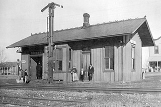
References

  1. Atlas of Great Lakes Indian History; Civilization of the American Indian Series; Helen Hornbeck Tanner; Cartography by Miklos Pinther; University of Oklahoma Press; Norman, Oklahoma, 1986; Pg 134;
  2. Nouvelle Devourverte d’un Pays plus grands que l’Europe situé dans l’Amérique. Louis Hennepin (Franciscan Recollect) Pg 113 of Bartlett (1899)
  3. Wallace, Paul A. W. (1961; 2nd edition, 2007). Indians in Pennsylvania. Pennsylvania Historical and Museum Commission; Diane Publishing Inc.
  4. Barr, Daniel P (2006). Unconquered: The Iroquois League at War in Colonial America. Greenwood Publishing Group. ISBN   0-275-98466-4.
  5. Jennings, Francis (1984). The Ambiguous Iroquois Empire. W. W. Norton & Company. ISBN   0-393-01719-2.
  6. Archives des Colonies, Paris. Cited by W. V. Kinietz, The Indians of the Western Great Lakes, 1615-1760, 309
  7. Baker, J. David. 1976. The Postal History of Indiana, Volume 2. Louisville, Kentucky: Leonard H. Hartmann. 1,061 p. [see p. 1,035]
  8. Goodspeed, Weston A., and Charles Blanchard. 1882. Counties of Lake and Porter, Indiana: Historical and Biographical. Chicago, Illinois: F. A. Battey and Company. 177 pgs; Chapt 8, pg 188
  9. Ball, Timothy H.; Northwestern Indiana From 1800 to 1900: A View of Our Region Through the Nineteenth Century. Chicago, Illinois: Donohue & Henneberry; 1900; 570 p. [see p. 322–323]
  10. 1 2 Plaque to Point Out Where Tassinong Once Flourished, The Vidette-Messenger, Valparaiso, Indiana; July 21, 1959 pg 4-5
  11. Town 33 Range 5, Jeremiah Smith, for Auditor of the State of Indiana, State of Indiana, 1875
  12. Town 34 Range 5, Jeremiah Smith, for Auditor of the State of Indiana, State of Indiana, 1875
  13. Maps of Indiana Counties in 1876, Reprinted from Illustrated Historical Atlas of the State of Indiana; Baskin, Forester & Co, Chicago, Illinois 1876; Indiana Historical Society 1968
  14. 1 2 The Era of Tassements, or Stockaded Trading Posts, Hubert Skinner, Indiana Magazine of History, 1-12 (1915-16), Department of History, Indian University, Volume XI, Bloomington, Indiana; 1915, Page 272
  15. The Meaning of "Tassinong", Jacob P. Dunn, Indiana Magazine of History 1-12 (1915-16), Department of History, Indian University, Volume XI, Bloomington, Indiana; 1915, Page 348
  16. Tassinong and Kouts: Siftings: Gleaned from Hither and Yon . . . and Now and Then . . . and Way back When --; A.J. Bowser; The Vidette-Messenger, Valparaiso, Indiana;; Oct 2, 1934
  17. KOUTS HIGH SCHOOL HISTORY OF PLEASANT TOWNSHIP, As Compiled By History Class and Instructors For The Vidette-Messenger; The Vidette-Messenger Centennial Edition, Valparaiso, Porter County, Indiana; August 18, 1936; Volume 10, Section 3, Pages 13-14.
  18. Tassinong Was Important Site; The Stroller, The Vidette-Messenger, Valparaiso, Indiana; June 13, 1957