Taunggyi Township | |
|---|---|
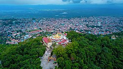 Shwe Bhone Pwint Pagoda and Taunggyi | |
 Location in Taunggyi district | |
| Coordinates: 20°47′N97°02′E / 20.783°N 97.033°E | |
| Country | |
| State | |
| District | Taunggyi District |
| Capital | Taunggyi |
| Area | |
• Total | 420.9 sq mi (1,090.0 km2) |
| Population (2014) | |
• Total | 381,639 |
| • Density | 906.83/sq mi (350.13/km2) |
| Time zone | UTC+6:30 (MMT) |
Taunggyi Township is a township of Taunggyi District in the Shan State of Myanmar. The principal town is Taunggyi.

