Theinni or Hsenwi is a town in northern Shan State of Burma, situated near the north bank of the Nam Tu River and now the centre of Hsenwi Township in Lashio District. It is 28 miles north of Lashio. It is 2,100 feet above sea level.

Möng Nai or Mongnai is a town in Mong Nai Township in the Shan State of Burma. Mong is equivalent to Mueang.
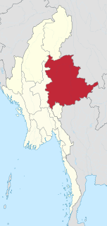
Mong Kung, Mongkung, Mongkaung or Möngkung, is a town in Shan State some 100 kilometres east of Mandalay. It is the capital of Mong Kung Township, Myanmar.
Mong Hsat is a town in the Shan State of Myanmar, the capital of Mong Hsat Township. It is served by Monghsat Airport.
Kyethi Township is a township of Loilem District in the Shan State of Burma. The main town is Kesi.
Mong Pan Township is a township of Loilen District in the Shan State of Myanmar. The capital town is Mong Pan or Möngpan, formerly the residence of the Sawbwa.
Mong Yawng Township is a township of Mong Hpayak District in the Shan State of Myanmar. The main town is Mong Yawng.
Kengtung District is a district of the Shan State in Myanmar. It consists of 3 towns and 1449 villages.
Loilem District is a district of the Shan State in Myanmar. It consists of 9 towns in 2010. Its capital is Loilem.
Mong Nawng, Mong Naung or Mongnawng is a town in Shan State, Myanmar. It is located a few miles to the west of the Nam Pang river.
Mong Hpayak is a town in Mong Hpayak District of Shan State of Myanmar. It is the principal town of and administrative center for both the district and Mong Hpayak Township. The town is located on the Tachilek–Kengtung paved road. As of 2005, a paved road was under construction from Mong Hpayak east to Mong Yawng.
Mong Yawng is a town, located in eastern Shan State, Myanmar.

Hsenwi was a Shan state in the Northern Shan States in what is today Burma. The capital was Hsenwi town.
South Hsenwi was a Shan state in the Northern Shan States in what is today Burma. The capital was Mongyai town which had a population of about 2000 in the 19th century.
North Hsenwi was a Shan state in the Northern Shan States in what is today Burma. The capital was Lashio town which was also the headquarters of the superintendent of the Northern Shan State. North Hsenwi, with an area of 6330 m², had a population in 1901 of 118,325 persons and an estimated revenue of £6000.

The Shan State Army-North, also known as Shan State Army/Special Region 3 (SSA/SR-3) is a Shan nationalist insurgent group in Myanmar (Burma). It is the armed wing of the Shan State Progress Party (SSPP).

Mongyang or Möngyang was a Shan state in what is today Burma. It was an outlying territory, located away from the main Shan State area in present-day Kachin State. The state existed before 1400 and after 1604. The main town was Mohnyin.
![miung:[?][?][?]: [?]ki[?]:ttNttaa:.jpg](http://upload.wikimedia.org/wikipedia/commons/thumb/6/6a/%E1%80%99%E1%80%AD%E1%80%AF%E1%80%84%E1%80%B9%E1%80%B8%E1%82%90%E1%80%BD%E1%80%B4%E1%80%B8_%E1%82%80%E1%80%80%E1%80%AD%E1%80%B3%E1%80%B8%E1%80%90%E1%80%B6%E1%80%90%E1%80%AC%E1%80%B8.jpg/250px-%E1%80%99%E1%80%AD%E1%80%AF%E1%80%84%E1%80%B9%E1%80%B8%E1%82%90%E1%80%BD%E1%80%B4%E1%80%B8_%E1%82%80%E1%80%80%E1%80%AD%E1%80%B3%E1%80%B8%E1%80%90%E1%80%B6%E1%80%90%E1%80%AC%E1%80%B8.jpg)