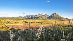
Shan State, also known by the endonyms Shanland, Muang Tai, and Tailong, is a state of Myanmar. Shan State borders China (Yunnan) to the north, Laos to the east, and Thailand to the south, and five administrative divisions of Burma (Myanmar) in the west. The largest of the 14 administrative divisions by land area, Shan State covers 155,800 km2, almost a quarter of the total area of Myanmar. The state gets its name from Burmese name for the Tai peoples: "Shan people". The Tai (Shan) constitute the majority among several ethnic groups that inhabit the area. Shanland is largely rural, with only three cities of significant size: Lashio, Kengtung, and the capital, Taunggyi. Taunggyi is 150.7 km northeast of the nation's capital Naypyitaw.

Wa State is an autonomous self-governing polity in Myanmar (Burma). It is de facto independent from the rest of the country and has its own political system, administrative divisions and army. However, the Wa State government recognises Myanmar's sovereignty over all of its territory, and the Burmese government does not consider Wa State's political institutions to be legitimate. The 2008 Constitution of Myanmar officially recognises the northern part of Wa State as the Wa Self-Administered Division of Shan State. As a one-party socialist state ruled by the United Wa State Party (UWSP), which split from the Communist Party of Burma (CPB) in 1989, Wa State is divided into three counties, two special districts, and one economic development zone. The administrative capital is Pangkham, formerly known as Pangsang. The name Wa is derived from the Wa ethnic group, who speak an Austroasiatic language.

The Kachin Independence Army is a non-state armed group and the military wing of the Kachin Independence Organisation (KIO), a political group of ethnic Kachins in Northern Myanmar. The Kachins are a coalition of six tribes whose homeland encompasses territory in China's Yunnan, Northeast India and Kachin State in Myanmar.

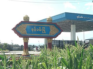
Laukkaing Township is a township located within Laukkaing District, Shan State, Myanmar. It is also part of the Kokang Self-Administered Zone. The principal town is Laukkai a.k.a. Laukkaing.

The following outline is provided as an overview of and topical guide to Myanmar:

Muse is the capital town of Mu Se Township in northern Shan State, Myanmar. It is situated on the Shweli River, and is connected by a bridge and road to Ruili in Yunnan Province, China.
Namhkam, also spelled Nam Kham is the principal town of Namhkam Township in northern Shan State, Myanmar, situated on the southern bank of the Shweli River near the border with Yunnan Province, China.
Mabein is a town in northern Shan State of Myanmar, formerly Burma. It is situated on the Shweli River and connected to Momeik, and to Bhamo and Myitkyina in Kachin State by road. Mabein lies only 90 km (56 mi) from the border with Yunnan Province, China, but 200 km (124 mi) north of Mandalay.

The Shan Nationalities League for Democracy is a political party in Myanmar (Burma). The party was established on 26 October 1988, and campaigns for the interests of the Shan people. The SNLD became the largest Shan party in the Assembly of the Union following the 2015 general election. The party is a federal party having local branches in most townships in Shan State and few in other states and regions such as Kayah, Kachin, and Mandalay.
Kutkai is a town and seat of Kutkai Township, in the Shan State of eastern-central Burma. It lies along National Highway 3, approximately 24 kilometres to the north of Lashio.

Dr Sai Mauk Kham is a Burmese politician and physician who currently serves as a House of Representatives MP for Lashio Township constituency. He previously served as First Vice President of Myanmar from 1 July 2012 to 30 March 2016. He was elected as Second Vice President of Myanmar on 4 February 2011, defeating Aye Maung of the Rakhine Nationalities Development Party and receiving 84% of the votes in the Amyotha Hluttaw.
Mahn Johnny is a Burmese politician, political prisoner and the former Chief Minister for Ayeyarwady Region. He is currently serving as a member of the Ayeyarwady Region Hluttaw for Kyonpyaw Township Constituency No. 2.

Opium production in Myanmar has historically been a major contributor to the country's gross domestic product (GDP). Myanmar is the world's second-largest producer of opium after Afghanistan, producing some 25% of the world's opium, and forms part of the Golden Triangle. The opium industry was a monopoly during colonial times and has since been illegally tolerated, encouraged and informally taxed by corrupt officials in the Tatmadaw, Myanmar Police Force and rebel fighters, primarily as the basis for heroin manufacture. In recent times however, opium poppy cultivation in Myanmar has declined year-on-year since 2015. According to latest data from the United Nations Office on Drugs and Crime (UNODC), an estimated 405 metric tons (mt) of opium were produced in Myanmar in 2020, representing less than half of the estimate of 2013, while the area of opium poppy cultivation declined by 11% from 33,100 in 2019 to 29,500 hectares (ha). With that said, the United Nations Office on Drugs and Crime (UNODC) has warned that opium production in Myanmar may rise again if the economic crunch brought on by COVID-19 and the country's February 1 military coup persists, with fallout for much of Asia.

Namhkam Township is a township of Mu Se District in the Shan State of eastern Myanmar. The principal town is Namhkam, a few miles away from Mu Se.

The Ta'ang National Liberation Army in Myanmar (Burma), is the armed wing of the Palaung State Liberation Front (PSLF).
The Kachin Defense Army was an armed insurgent group that operated in northern Shan State, Myanmar, until its conversion into a border guard force in January 2010.
T Khun Myat is a Burmese politician, lawyer and Speaker of the Union Assembly, the Joint House and Pyithu Hluttaw, the lower house of the Myanmar parliament. In both 2010 election and 2015 election, he contested and won the Kutkai Township constituency for a seat in the country's lower house.
Pat Jasan is an anti-drug organisation founded in 2014 in Kachin State Myanmar. The organisation has been described as "vigilantes", "an ethnic Kachin public movement", "militant christians" a "civilian movement" and Myanmar's "largest civilian uprising in nearly a decade".
Loikan is a village in Kyaukme Township, Shan State, Burma.
Lahpai Maw Htun Aung is a Burmese politician, social activist and technologist. He is a deputy minister of electricity and energy of the National Unity Government of Myanmar formed by the opponents of the 2021 Myanmar coup d'état.