The Palaung or Ta'ang are a Mon–Khmer ethnic minority found in Shan State of Burma, Yunnan Province of China and Northern Thailand. In China, they are referred to as the De'ang people.

Shan State is a state of Myanmar. Shan State borders China (Yunnan) to the north, Laos to the east, and Thailand to the south, and five administrative divisions of Burma (Myanmar) in the west. The largest of the 14 administrative divisions by land area, Shan State covers 155,800 km2, almost a quarter of the total area of Myanmar. The state gets its name from Burmese name for the Tai peoples: "Shan people". The Tai (Shan) constitute the majority among several ethnic groups that inhabit the area. Shanland is largely rural, with only three cities of significant size: Lashio, Kengtung, and the capital, Taunggyi. Taunggyi is 150.7 km northeast of the nation's capital Naypyitaw.
Bhamo is a city in Kachin State in northern Myanmar, 186 km (116 mi) south of the state capital, (Myitkyina). It is on the Ayeyarwady River. It lies within 65 km (40 mi) of the border with Yunnan Province, China. The population consists of Chinese and Shan, with Kachin peoples in the hills around the town. It is the administrative center of Bhamo District and Bhamo Township.

Kalaw is a hill town in the Shan State of Myanmar. It is located in Kalaw Township in Taunggyi District.
Mong Ton also known historically as Möngtung and Maington, is a town and seat of Mong Tong Township in Mong Hsat District, Shan State in eastern Myanmar near the border with Thailand. Mong is equivalent to [Township or land]."Ton"is equivalent to [Royal City]. It is located in the Daen Lao Range, in the eastern part of the Shan State, east of the Salween River. Mong Ton lies on the National Highway 45 and connected to Nar Kaung Mu and Pone Par Kyin, is also connected to Mong Hsat by National Highway 49 which begins to the north-east of the town.

Kyethi Township is a township of Loilem District in the Shan State of Burma. The main town is Kesi.
Tangyan Township is a township of Lashio District in the Shan State of eastern Burma. The principal town is Tangyan. Tangyan emerged as an important centre for Panthay people in the mid-20th century, especially after the destruction of Panglong during World War II.

Mu Se Township is a township of Mu Se District in the Shan State of eastern Burma. The principal town and administrative center is Muse. It is the terminus of Mandalay-Lashio-Muse road.

Kutkai Township is a township of Muse District in the Shan State of eastern Burma. The principal town is Kutkai.

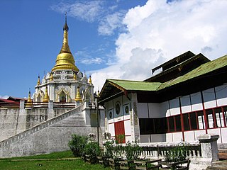
Nawnghkio Township is a township of Kyaukme District in the Shan State of eastern Myanmar. The principal town and administrative seat is Nawnghkio. The name 'Nawnghkio' was started to call after a camp near a green lake. The lake is located in the west of 'Haw Taw Monastery' of today's Nawnghkio.

Mong Ton Township or Mong Tong Township is a township of Mongs Ton District in the Eastern Shan State of Myanmar. The capital town is Mong Ton. It borders Mong Pying Township to the north, Mong Hsat Township to the east, Mong Nai Township and Mong Pan Township to the west and Thailand to the south. Loi Hkilek mountain is located in the area. It has two townships. They are Pone Par Khem, and Mong Hta. At Mong Ton township, live in Shan, Lahu, Lisu, Wa, Burma, and Chinese.

Muse is the capital of Mu Se Township in northern Shan State, Myanmar. It is situated on the Shweli River, and is connected by a bridge to Ruili in Yunnan Province, China. The border town is a major regional trade hub with China..

Kyaukme is a town in northern Shan State of Burma. It is situated on the Mandalay - Lashio road, after Pyin Oo Lwin and Nawnghkio, and before Hsipaw, on what is now the Mandalay - Muse road, part of the Asian Highway route 14 (AH14). It is also connected to Momeik (Mongmit) in the Shweli River valley and Mogok with its ruby mines. Kyaukme can be reached by train on the Mandalay-Lashio railway line. As of 2014, the population was 39,930.
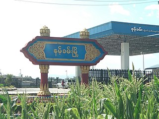
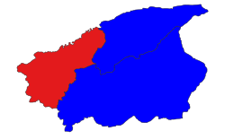
Namhkam, also spelled Nam Kham is the principal town of Namhkam Township in northern Shan State, Myanmar, situated on the southern bank of the Shweli River near the border with Yunnan Province, China.

The Palaung Self-Administered Zone is a self-administered zone consisting of two townships in Shan State: It was created as a separately administered unit by the 2008 Constitution. Its official name was announced by decree on 20 August 2010. The zone is to be self-administered by the Palaung people. Its capital is the town of Namhsan.
Mong Ko, sometimes spelled Mongko or Monekoe and also known as Man Kan, Man Guo and Panglong, is a town in Mu Se Township, Mu Se District, northern Shan State.

The Shan State Army – North, also known as Shan State Army/Special Region 3 (SSA/SR-3) is a Shan nationalist insurgent group in Myanmar (Burma). It is the armed wing of the Shan State Progress Party (SSPP).

Pang Hseng, also known as Pan Saing, Kyu Koke and Kyu-hkök, is a town in Mu Se Township, Mu Se District, northern Shan State, Myanmar.
Lahpai Maw Htun Aung is a Burmese politician, social activist and technologist. He is a deputy minister of electricity and energy of the National Unity Government of Myanmar formed by the opponents of the 2021 Myanmar coup d'état.
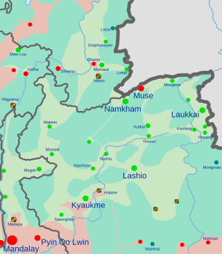
Operation 1027 is a joint military operation conducted by the Three Brotherhood Alliance, a military coalition composed of the Arakan Army (AA), Myanmar National Democratic Alliance Army (MNDAA), and Ta'ang National Liberation Army (TNLA), ethnic armed organisations in Myanmar. The joint forces launched simultaneous attacks in multiple towns in northern Shan State, targeting the Myanmar Army, Myanmar Police, and pro-military militia installations in Kutkai, Kyaukme, Muse, Namhkam, Nawnghkio, Lashio, and Chinshwehaw. The rebels later expanded their offensive outside Shan State, staging attacks in Mogok, Mandalay and Htigyaing, Sagiang Region. By the end of 8 November, the Brotherhood Alliance claimed to have captured a total of 125 army outposts across the region. Other anti-junta groups in the country, such as the People's Defense Force (PDF), pledged their support for and participation in the operation, conducting further attacks on the regime.