
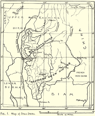
Laihka State, also spelt Legya or Lecha, was a state in the central division of the Southern Shan States of Burma, with an area of 3,711 square kilometres (1,433 sq mi).
Kengcheng or Keng Cheng was one of the Shan states. In 1896, part of Keng Cheng was incorporated into the neighbouring state of Kengtung in what is today Burma, and the other part, which is now in Laos, went to French Indochina.

Kenghkam or Keng Hkam was a Shan state in what is today Burma. The capital was the town of Keng Hkam, located by the Nam Pang River.
Kenglon, also known as Kyainglun was a small Shan state in what is today Burma.
Loi-ai was a Shan state in the Myelat region of what is today Burma. It was one of the westernmost Shan states, bordering with Yamethin district of Upper Burma. The capital was Lonpo (Aungpan) and the population was mostly Pa-O, but there were also Danu, Shan and Karen people in the area.
Mawnang was a small Shan state in the Myelat region of what is today Burma. Its population was mostly Taungyo.
Mongnawng was a large Shan state in what is today Burma.
Mongpawn, also known as Maingpun, was a Shan state in what is today Burma. The state was part of the Eastern Division of the Southern Shan States and was located south of Laihka State in the valley of the Nam Pawn river.
Mongsang was a Shan state in what is today Burma.
Mongsit or Möngsit, also known as Maingseik was small state of the Shan States in what is today Burma.
Kehsi Mansam was a Shan state in what is today Burma. It belonged to the Eastern Division of the Southern Shan States. Its capital was Kehsi town, located by the Nam Heng River. The state included 378 villages and the population was mostly Shan, but there were also some Palaung people (Yins) in the area

Western Karenni was the collective name for the four Karenni States located west of the Salween River: Bawlake, Nammekon, Naungpale, and Kyebogyi. On 21 June 1875, the government of British India and king Mindon of Burma signed a treaty recognizing the independence of Western Karenni. On 23 January 1892, Western Karenni was incorporated into British India as a protectorate.
South Hsenwi was a Shan state in the Northern Shan States in what is today Burma. The capital was Mongyai town which had a population of about 2000 in the 19th century.
North Hsenwi was a Shan state in the Northern Shan States in what is today Burma. The capital was Lashio town which was also the headquarters of the superintendent of the Northern Shan State. North Hsenwi, with an area of 6330 m², had a population in 1901 of 118,325 persons and an estimated revenue of £6000.

Mawkmai, also known as Maukme, was a Shan State in what is today Burma. It belonged to the Eastern Division of the Southern Shan States.
Mongkung, also known as Maingkaing, was a Shan state in what is today Burma. It belonged to the Eastern Division of the Southern Shan States. Its capital was Mong Kung, in the valley of the Nam Teng. The largest minority were Palaung people.
Mongpan, also known as Maingpan was a Shan state in what is today Burma. It belonged to the Eastern Division of the Southern Shan States.
Lawksawk, also known as Yatsawk was a Shan state in what is today Burma. It was located north of Myelat and belonged to the Central Division of the Southern Shan States. Its capital was Lawksawk town. The state included 397 villages and the population was mostly Shan, but there were also Danu, Pa-O and Palaung people in the area.

Mongpai, also known as Mobye, was a Shan state in what is today Burma. It belonged to the Central Division of the Southern Shan States. Mongpai was based in the modern town of Mobye.
Tawngpeng was a Shan state in what is today Myanmar. It belonged to the Northern Shan States. The capital was Namhsan (Om-yar).