Hsamonghkam

Last updated

Hsamonghkam or Hsamönghkam (also known as Thamaingkan) was a Shan state in the Myelat region of Burma. Its capital was Aungban.

Myelat Historical region in Myanmar

Myelat is a historical region of the southwestern Shan State of Myanmar. Originally this region included some of the smaller states typically ruled by "Myosas" or "Ngwegunhmus", buffering the plains of Burma and the ethnic Shan states further east.

Aungban Place in Shan State, Myanmar

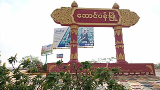
Aungban is a town located in the Southern Shan State. It is located in Kalaw Township which is part of Taunggyi District. It lies at the elevation of 4219 feet above sea level. As of September 2017, its population was recorded 30313. It is a junction town and thus majority of agricultural products from nearby towns and villages are collected there by traders and distributed to other parts of country, especially to Yangon, Mandalay, Kayin and Mon States.

Hsamonghkam was established before 1700 CE. During the 18th and 19th centuries it was a tributary of Burma. In 1886, following the fall of the Konbaung dynasty, it submitted to British rule. It became a part of the unified Shan State within Burma in 1947.

Konbaung dynasty last dynasty that ruled Burma/Myanmar from 1752 to 1885

The Konbaung dynasty, formerly known as the Alompra dynasty, or Alaungpaya dynasty, was the last dynasty that ruled Burma/Myanmar from 1752 to 1885. It created the second-largest empire in Burmese history and continued the administrative reforms begun by the Toungoo dynasty, laying the foundations of the modern state of Burma. The reforms, however, proved insufficient to stem the advance of the British, who defeated the Burmese in all three Anglo-Burmese wars over a six-decade span (1824–1885) and ended the millennium-old Burmese monarchy in 1885.

Shan State State in East central, Myanmar

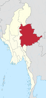
Shan State is a state of Myanmar. Shan State borders China to the north, Laos to the east, and Thailand to the south, and five administrative divisions of Burma in the west. Largest of the 14 administrative divisions by land area, Shan State covers 155,800 km², almost a quarter of the total area of Burma. The state gets its name from the Shan people, one of several ethnic groups that inhabit the area. Shan State is largely rural, with only three cities of significant size: Lashio, Kengtung, and the capital, Taunggyi. Taunggyi is 150.7 km north east of the nation's capital Naypyitaw.

Sao Htun Aye, The last myosa of Hsamonghkam, abdicated and surrendered his powers to the Burmese government on 29 April 1959.

Related Research Articles

Karenni States

The Karenni States, also known as Red Karen States, was the name formerly given to the states inhabited mainly by the Red Karen, in the area of present-day Kayah State, eastern Burma. They were located south of the Federated Shan States and east of British Burma.

Hkamti Long

Hkamti Long was a Shan state in what is today Burma. It was an outlying territory, located by the Mali River, north of Myitkyina District, away from the main Shan State area in present-day Kachin State. The main town was Putao.

Shan States historic (1885-1948) name for Minor Kingdoms (analogous to Princely state of British India) ruled by Saopha (similar to Thai royal title Chao Fa Prince/Princess) in areas of todays Burma, China, Laos and Northern Thailand from c.1215 to c.1959

The Shan States (1885–1948) were a collection of minor Shan kingdoms called mueang whose rulers bore the title saopha in British Burma. They were analogous to the princely states of British India.

Mong Nai Town in Shan, Myanmar

Möng Nai or Mongnai is a town in Mong Nai Township in the Shan State of Burma. Mong is equivalent to Mueang.

Yawnghwe former Shan state in what is today Burma

Yawnghwe, known as Nyaungshwe in Burmese, was a Shan state in what is today Myanmar. It was one of the most important of the Southern Shan States. Yawnghwe state included the Inle Lake. The administrative capital was Taunggyi, located in the northern part of the state. The Agent of the British government, the Superintendent of the Southern Shan States, resided at Taunggyi and the king's palace was at Yawnghwe.

Panglong Agreement

The Panglong Agreement was reached in Panglong, Southern Shan State, between the Burmese government under Aung San and the Shan, Kachin, and Chin peoples on 12 February 1947. Aung Zan Wai, Pe Khin, Bo Hmu Aung, Sir Maung Gyi, Dr. Sein Mya Maung, Myoma U Than Kywe were among the negotiators of the historical Panglong Conference negotiated with Bamar leader General Aung San and other ethnic leaders in 1947. The agreement accepted "Full autonomy in internal administration for the Frontier Areas" in principle and envisioned the creation of a Kachin State by the Constituent Assembly. It continued the financial relations established between the Shan states and the Burmese federal government, and envisioned similar arrangements for the Kachin Hills and the Chin Hills.

Loi-ai

Loi-ai was a Shan state in the Myelat region of what is today Burma. It was one of the westernmost Shan states, bordering with Yamethin district of Upper Burma. The capital was Lonpo (Aungpan) and the population was mostly Pa-O, but there were also Danu, Shan and Karen people in the area.

Maw (state)

Maw, was a Shan state in what is today Burma. It was the northernmost and the second largest of the states of the Myelat region at the western end of the Shan States.

Pangmi was a Shan state in the Myelat region of what is today Burma. It was very small, having an area of only 29 sq mi (75 km2), and was almost entirely enclosed by Hsamonghkam. Its population was mostly Danu and Pa-O.

Hsatung was a Shan state in what is today Burma.

South Hsenwi

South Hsenwi was a Shan state in the Northern Shan States in what is today Burma. The capital was Mongyai town which had a population of about 2000 in the 19th century.

Mongkung State

Mongkung or Möngküng was a Shan state in what is today Burma. It belonged to the Eastern Division of the Southern Shan States. Its capital was Mong Kung, in the valley of the Nam Teng. The largest minority were Palaung people.

Mongnai State

Mongnai, also known as Möngnai, Mone, Mōng Nai or Monē, was a Shan state in what is today Burma. It belonged to the Eastern Division of the Southern Shan States. Its capital was Mongnai town.

Mongpai was a Shan state in what is today Burma. It belonged to the Central Division of the Southern Shan States.

Tawngpeng State

Tawngpeng was a Shan state in what is today Myanmar. It belonged to the Northern Shan States. The capital was Namhsan (Om-yar).

Wanyin was a Shan state in what is today Burma. It belonged to the Central Division of the Southern Shan States.

Pangtara was a Shan state in what is today the Pindaya Township of Burma. It belonged to the Myelat Division of the Southern Shan States.

Yengan was a Shan state in what is today Burma. It belonged to the Myelat Division of the Southern Shan States.

References