
Shan State is a state of Myanmar. Shan State borders China (Yunnan) to the north, Laos to the east, and Thailand to the south, and five administrative divisions of Myanmar in the west. The largest of the 14 administrative divisions by land area, Shan State covers 155,800 km2, almost a quarter of the total area of Myanmar. The state gets its name from the Burmese name for the Tai peoples: "Shan people". The Tai (Shan) constitute the majority among several ethnic groups that inhabit the area. Shanland is largely rural, with only three cities of significant size: Lashio, Kengtung, and the capital, Taunggyi. Taunggyi is 150.7 km northeast of the nation's capital Naypyitaw.

The Karenni States, also known as Red Karen States, was the name formerly given to the states inhabited mainly by the Red Karen, in the area of present-day Kayah State, eastern Burma. They were located south of the Federated Shan States and east of British Burma.

The Shan States were a collection of minor Shan kingdoms called muang whose rulers bore the title saopha in British Burma. They were analogous to the princely states of British India.

Theinni or Hsenwi is a town in northern Shan State of Burma, situated near the north bank of the Nam Tu River and now the centre of Hsenwi Township in Lashio District. It is 28 miles (45 km) north of Lashio and 2,100 feet (640 m) above sea level.
Mang Lon, Manglon, Manglun, Manglön, or Mang Lön a state in the northern Shan states of Myanmar, was formerly the chief state of the Wa people. It is a mountainous territory, including the valleys of the Salween and its tributary the Nam Hka. It had an approximate area of 7770 km2 and its estimated population in 1911 was 40,000.
Laihka State, also spelt Legya or Lecha, was a state in the central division of the Southern Shan States of Burma, with an area of 3,711 square kilometres (1,433 sq mi).
Yawnghwe, known as Nyaungshwe in Burmese, was a Shan state in what is today Myanmar. It was one of the most important of the Southern Shan States. Yawnghwe state included the Inle Lake. The administrative capital was Taunggyi, located in the northern part of the state. The Agent of the British government, the Superintendent of the Southern Shan States, resided at Taunggyi and the king's palace was at Yawnghwe.

Kengtung Township is a township of Kengtung District in the Shan State of Myanmar. The principal town is Kengtung. It lies almost entirely east of the Salween River and its area is over 12,000 square miles (31,000 km2). It is bounded on the north by the states of Mang Lon, Mong Lem and Keng Hung ; east by the Mekong River, south by the Siamese Shan States, and west in a general way by the Salween River, though it overlaps it in some places. The state is known to the Chinese as Mhng Khng, and was frequently called by the Burmese the 32 cities of the Gn (HkOn). The classical name of the state is Khemarata or Khemarata Tungkapuri.
Momeik, also known as Mong Mit in Shan, is a town situated on the Shweli River in northern Shan State. It is the principal town of Mongmit Township, Myanmar.
Kenglon, also known as Kyainglun was a small Shan state in what is today Burma.
Kantarawadi, also known as Gantarawadi, was one of the Karenni States in what is today Kayah State in Burma. It was also known as "Eastern Karenni" owing to the location of part of its territory east of the Salween River.
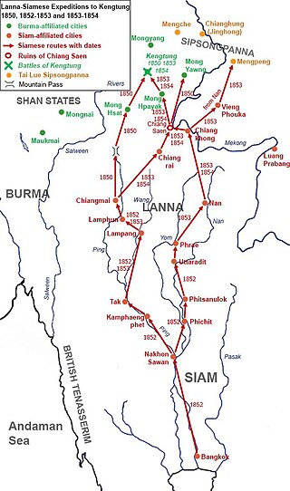
The Burmese–Siamese War of 1849–1855 or Siamese Invasions of Kengtung or Kengtung Wars were military expeditions of the Siamese Rattanakosin Kingdom against the Tai Khün State of Kengtung, which had been under Burmese suzerainty under the Konbaung dynasty. The dynastic struggles in Tai Lue State of Chiang Hung or Sipsongpanna prompted Siam, in cooperation with the Kingdom of Lanna, to invade Kengtung in order to gain access to Chiang Hung. In the First Invasion in 1850, the Siamese court had ordered the Lanna Lord of Chiang Mai to organize the offensives against Kengtung. Lanna troops failed to conquer Kengtung. Two other expeditions occurred in 1852 and 1853 as Bangkok commanded its troops to directly participate in the invasions. Both expeditions also failed because of internal issues and geographical unfamiliarity. The State of Kengtung under the leadership of Saopha Maha Khanan, with limited assistance from Burma who had been embroiling in the Second Anglo-Burmese War, managed to resist Siamese-Lanna invasions three times.
Hsipaw, also known as Thibaw or Ông Pawng, was a Shan state in what is today Myanmar. Its capital was Hsipaw town. Hsipaw State was perhaps one of the most well known and powerful Shan States.
Mongmit or Möngmit, also known as Momeik, was a Shan state in the Northern Shan States in what is today Burma. The capital was Mongmit town. The state included the townships of Mongmit and Kodaung.
Hsenwi, also known as Theinni, was a Shan state in the Northern Shan States in what is today Burma. The capital was Hsenwi town.
North Hsenwi was a Shan state in the Northern Shan States in what is today Burma. The capital was Lashio town which was also the headquarters of the superintendent of the Northern Shan State. North Hsenwi, with an area of 6330 m², had a population in 1901 of 118,325 persons and an estimated revenue of £6000.

Mawkmai, also known as Maukme, was a Shan State in what is today Burma. It belonged to the Eastern Division of the Southern Shan States.

Monghsu or Maingshu was a Shan state in what is today Burma. It belonged to the Eastern Division of the Southern Shan States. The main river in the area was the Nam Pang.
Mongpan, also known as Maingpan was a Shan state in what is today Burma. It belonged to the Eastern Division of the Southern Shan States.
Kengtung, known as Menggen Prefecture or Möng Khün Chiefdom or Mueng Khuen Fu, classical name Khemarattha, was a Shan state from 1405 to 1895 in what is today Burma. The capital and the residence of the ruler was Kengtung in the centre of the state. It was the only urban area in this mountainous state whose landscape is dominated by the Daen Lao Range.
