Myelat

Last updated
Myelat
မြေလတ်
Historical region

KAREN LADIES POSED FOR THEIR PICTURES BY AN OFFICIOUS HEADMAN.jpg

Picture of people in Myelat taken by Sir George Scott (1851–1935).
MyanmarShan.png
A map of Shan State
Country Myanmar
Elevation 880 m (2,890 ft)
Population (1897)
  Total 107,500

Myelat (Burmese : ‌မြေလတ်) is a historical region of the southwestern Shan State of Myanmar. Originally this region included some of the smaller states typically ruled by "Myosas" (chief of town) or "Ngwegunhmus" (silver revenue chief), buffering the plains of Burma and the ethnic Shan states further east.

Burmese language language spoken in Myanmar

The Burmese language is the Sino-Tibetan language spoken in Myanmar where it is an official language and the language of the Bamar people, the country's principal ethnic group. Although the Constitution of Myanmar officially recognizes the English name of the language as the Myanmar language, most English speakers continue to refer to the language as Burmese, after Burma, the older name for Myanmar. In 2007, it was spoken as a first language by 33 million, primarily the Bamar (Burman) people and related ethnic groups, and as a second language by 10 million, particularly ethnic minorities in Myanmar and neighboring countries.

Historical regions are geographic areas which at some point in time had a cultural, ethnic, linguistic or political basis, regardless of present-day borders. They are used as delimitations for studying and analysing social development of period-specific cultures without any reference to contemporary political, economic or social organisations.

The fundamental principle underlying this view is that older political and mental structures exist which exercise greater influence on the spatial-social identity of individuals than is understood by the contemporary world, bound to and often blinded by its own worldview - e.g. the focus on the nation-state.

Shan State State in East central, Myanmar

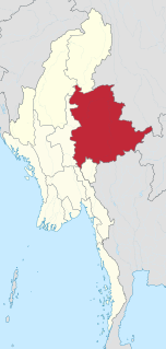
Shan State is a state of Myanmar. Shan State borders China to the north, Laos to the east, and Thailand to the south, and five administrative divisions of Burma in the west. Largest of the 14 administrative divisions by land area, Shan State covers 155,800 km², almost a quarter of the total area of Burma. The state gets its name from the Shan people, one of several ethnic groups that inhabit the area. Shan State is largely rural, with only three cities of significant size: Lashio, Kengtung, and the capital, Taunggyi. Taunggyi is 150.7 km north east of the nation's capital Naypyitaw.

Contents

The term "Myelat" is still in common use today, although the old political and administrative distinctions no longer apply.

Geography

The area is hemmed in on the north by the state of Lawksawk, on the east by the states of Yawnghwe, Wanyin and Hsatung, and on the south by Mong Pai.

Lawksawk Town in Shan State, Myanmar

Lawksawk is a town in Shan State, Myanmar. It is the capital town and administrative center of Lawksawk Township. The town is located along an oxbow lake of the Zawgyi River at an altitude of 910 meters. Lawksawk is about 48 kilometres (30 mi) north of Taunggyi, or 70 kilometres (43 mi) by road on National Route 43. It was the historical capital of Lawksawk State.

Yawnghwe former Shan state in what is today Burma

Yawnghwe, known as Nyaungshwe in Burmese, was a Shan state in what is today Myanmar. It was one of the most important of the Southern Shan States. Yawnghwe state included the Inle Lake. The administrative capital was Taunggyi, located in the northern part of the state. The Agent of the British government, the Superintendent of the Southern Shan States, resided at Taunggyi and the king's palace was at Yawnghwe.

Wanyin was a Shan state in what is today Burma. It belonged to the Central Division of the Southern Shan States.

In 1897, the population was recorded as 107,500, the majority being of the Taungthu or Pa-O (42,933), followed by Danu (29,713), Taungyo (13,906), Shan (6,572), and a smaller number of other ethnic groups.

The name Myelat could be interpreted as "unoccupied land" in Burmese, however the land has been populated for quite some time. The name could also be interpreted as "middle earth", implying a buffer zone, or "fair earth", depending on a variation of the spelling. All central Myelat and great parts of the northern and southern portions consist of rolling grassy downs bare of jungle. The area is productive in agriculture, crops grown include potatoes, corn, wheat, cabbage, cauliflower, oranges, coffee, as well as rice. Visitors to the area immediately notice the red earth of the countryside, due to high iron oxide content of the soil. [1]

Jungle an impassable dense forest (typically tropical)

A jungle is land covered with dense vegetation dominated by trees. Application of the term has varied greatly during the past recent centuries. Before the 1970s, tropical rainforests were generally referred to as jungles but this terminology has fallen out of usage. Jungles in Western literature can represent a less civilised or unruly space outside the control of civilization, attributed to the jungle's association in colonial discourse with places colonised by Europeans.

Myelat Division

The exact composition of the states within the Myelat area has changed through history, dependent on vagaries of local power politics as well as approval by the Burmese court. At times, states have been combined, at other times, they have been split up.

At the time of the British annexation of the Shan States, the following sixteen states were recognized to be within the Myelat region: Hsamonghkam, Kyawkku Hsiwan, Kyong, Loi-ai, Loilong, Loimaw, Maw, Mawnang, Mawson, Namhkai, Namhkom, Namtok, Pangmi, Pangtara, [2] Poila, and Yengan. [3] The total area of these states was approximately 3,900 square miles (10,000 km2).

Shan States historic (1885-1948) name for Minor Kingdoms (analogous to Princely state of British India) ruled by Saopha (similar to Thai royal title Chao Fa Prince/Princess) in areas of todays Burma, China, Laos and Northern Thailand from c.1215 to c.1959

The Shan States (1885–1948) were a collection of minor Shan kingdoms called mueang whose rulers bore the title saopha in British Burma. They were analogous to the princely states of British India.

Hsamonghkam or Hsamönghkam was a Shan state in the Myelat region of Burma. Its capital was Aungban.

Kyong

Kyong was a Shan state in the Myelat region of what is today Burma.

Related Research Articles

Taunggyi City in Shan State, Myanmar

Taunggyi is the capital and largest city of Shan State, Myanmar (Burma) and lies on the Thazi-Kyaingtong road at an elevation of 4,712 feet, just north of Shwenyaung and Inle Lake within the Myelat region. Taunggyi is the fifth largest city of Myanmar, and has an estimated population of 380,665 as of 2014.The city is famous for its hot air balloon festival held annually on the full moon day of Tazaungmon.

Loi-ai

Loi-ai was a Shan state in the Myelat region of what is today Burma. It was one of the westernmost Shan states, bordering with Yamethin district of Upper Burma. The capital was Lonpo (Aungpan) and the population was mostly Pa-O, but there were also Danu, Shan and Karen people in the area.

Loimaw was a Shan state in the Myelat region of what is today Burma. Its capital was Minywa. Its population was mostly Pa-O.

Maw (state)

Maw, was a Shan state in what is today Burma. It was the northernmost and the second largest of the states of the Myelat region at the western end of the Shan States.

Mawson was a Shan state in the Myelat region of what is today Burma. Its capital was Myogyi. Its population consisted of Danu, Pa-O, and Taungyo.

Mawnang was a small Shan state in the Myelat region of what is today Burma. Its population was mostly Taungyo.

Namhkai was a Shan state in the Myelat region of what is today Burma. Its capital was Paw-in. Its population was almost entirely Pa-O.

Namtok, Myelat Village and former state in Shan State, Burma

Namtok is a village and a former Shan state in the Myelat region of what is today Burma. It was small, having an area of only 20 sq mi (52 km2). Today it is located in Langhko Township in Langhko District just to the northeast of Langhko town.

Pangmi was a Shan state in the Myelat region of what is today Burma. It was very small, having an area of only 29 sq mi (75 km2), and was almost entirely enclosed by Hsamonghkam. Its population was mostly Danu and Pa-O.

Poila was a Shan state in the Myelat region of what is today Burma. Its population was mostly Taungyo, with the remainder being Danu and Pa-O.

Lawksawk State

Lawksawk (Yatsawk) was a Shan state in what is today Burma. It was located north of Myelat and belonged to the Central Division of the Southern Shan States. Its capital was Lawksawk town. The state included 397 villages and the population was mostly Shan, but there were also Danu, Pa-O and Palaung people in the area.

Tawngpeng State

Tawngpeng was a Shan state in what is today Myanmar. It belonged to the Northern Shan States. The capital was Namhsan (Om-yar).

Namtok was a Shan state in what is today Burma. It belonged to the Myelat Division of the Southern Shan States.

Pangtara was a Shan state in what is today the Pindaya Township of Burma. It belonged to the Myelat Division of the Southern Shan States.

Yengan was a Shan state in what is today Burma. It belonged to the Myelat Division of the Southern Shan States.

Wa States

The Wa States was the name formerly given to the Wa Land, the natural and historical region inhabited mainly by the Wa people, an ethnic group speaking an Austroasiatic language. The region is located to the northeast of the Shan States of British Burma, in the area of present-day Shan State of northern Burma (Myanmar) and the western zone of Pu'er Prefecture, Yunnan, China.

Wanmaw State

Wanmaw, Manmaw or Banmaw (Bhamo) was a Shan state in what is today Burma. It was an outlying territory, located away from the main Shan State area in present-day Kachin State close to the border with China.

References

  1. J. G. Scott, Gazetteer of Upper Burma and the Shan States. 5 vols. Rangoon, 1900-1901
  2. Than Tun, History of Pindaya (Town, Pagoda, and Cave). Thein Hteik Yadana Publications, 1998
  3. "WHKMLA : History of the Shan States". 18 May 2010. Retrieved 21 December 2010.

Coordinates: 20°57′N96°40′E / 20.950°N 96.667°E / 20.950; 96.667

Geographic coordinate system Coordinate system

A geographic coordinate system is a coordinate system that enables every location on Earth to be specified by a set of numbers, letters or symbols. The coordinates are often chosen such that one of the numbers represents a vertical position and two or three of the numbers represent a horizontal position; alternatively, a geographic position may be expressed in a combined three-dimensional Cartesian vector. A common choice of coordinates is latitude, longitude and elevation. To specify a location on a plane requires a map projection.