
The Yakima River is a tributary of the Columbia River in south central and eastern Washington state, named for the indigenous Yakama people. Lewis and Clark mention in their journals that the Chin-nâm pam called the river Tâpe têtt, possibly from the French tape-tête, meaning "head hit". The length of the river from headwaters to mouth is 214 miles (344 km), with an average drop of 9.85 feet per mile (1.866 m/km). It is the longest river entirely in Washington state.

The Lewis River is a tributary of the Columbia River, about 95 miles (153 km) long, in southwestern Washington in the United States. It drains part of the Cascade Range north of the Columbia River. The drainage basin of the Lewis River covers about 1,046 square miles (2,709 km2). The river's mean annual discharge is about 6,125 cubic feet per second (173.4 m3/s). Unlike nearby Lewis County and Fort Lewis the Lewis River was not named for Meriwether Lewis, but rather for A. Lee Lewis, an early colonizer who homesteaded near the mouth of the river.
The North Fork Toutle River is a tributary of the Toutle River in southwestern Washington in the United States. The river has its headwaters near Spirit Lake, on the north side of Mount St. Helens, and flows 39 miles (63 km) to the Toutle River, about 17 miles (27 km) upstream of its confluence with the Cowlitz River. The largest tributary is the Green River, which joins near the unincorporated town of Toutle.

The Klickitat River is a tributary of the Columbia River, nearly 96 miles (154 km) long, in south-central Washington in the United States. It drains a rugged plateau area on the eastern side of the Cascade Range northeast of Portland, Oregon. In 1986, 10 miles (16 km) of the river were designated Wild and Scenic from the confluence with Wheeler Creek, near the town of Pitt, to the confluence with the Columbia River.

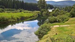
The Cle Elum River is a tributary of the Yakima River, approximately 28 miles (45 km) long in the U.S. state of Washington. A Northern Pacific Railway station at the future site of the city of Cle Elum, Washington was named Clealum after the Kittitas name Tie-el-Lum, meaning "swift water", referring to the Cle Elum River. In 1908, Clealum was altered to Cle Elum. This spelling came to be used for the river as well. Some maps in the 1850s also have the river labeled as Samahma River.

The Naches River is a tributary of the Yakima River in central Washington in the United States. Beginning as the Little Naches River, it is about 75 miles (121 km) long. After the confluence of the Little Naches and Bumping River the name becomes simply the Naches River. The Naches and its tributaries drain a portion of the eastern side of the Cascade Range, east of Mount Rainier and northeast of Mount Adams. In terms of discharge, the Naches River is the largest tributary of the Yakima River.

The Tieton River is a tributary of the Naches River, in Yakima County, Washington in the United States.

The Bumping River is a tributary of the Naches River, in Washington in the United States. It flows down the east side of the Cascade Range, through Wenatchee National Forest and the William O. Douglas Wilderness. From its source at Fish Lake near Crag Mountain, it flows northeast to Bumping Lake, a natural lake enlarged and regulated by Bumping Lake Dam. Below the dam, the Bumping River continues flowing northeast. It is joined by the American River, its main tributary, a few miles above its mouth where it joins the Little Naches River to form the Naches River.
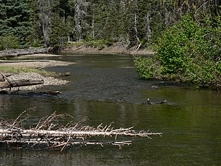
The American River is a tributary of the Bumping River in Washington. It flows down the east side of the Cascade Range, through Wenatchee National Forest and the William O. Douglas Wilderness.

Cle Elum Lake is a lake and reservoir along the course of the Cle Elum River, in Washington state USA. At the site of the future city of Cle Elum, Washington, a Northern Pacific Railway station was named Clealum after the Kittitas name Tle-el-Lum (tlielləm), meaning "swift water", referring to the Cle Elum River. The lake was also labeled as Kleattam Lake in maps of the 1850s.

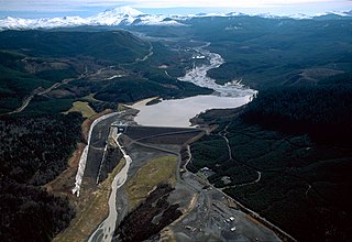
Keechelus Lake is a lake and reservoir in the northwest United States, near Hyak in Kittitas County, Washington. Approximately fifty miles (80 km) southeast of Seattle and a few miles southeast of Snoqualmie Pass, it is the source of the Yakima River.
The Yaak River is a tributary of the Kootenai River in Montana.
The Fisher River is a tributary of the Kootenay River in the U.S. state of Montana. The Fisher River properly begins at the confluence of its two main tributaries, the Pleasant Valley Fisher River and the Silver Butte Fisher River. Of the two tributaries, the Pleasant Valley Fisher River is the larger and is sometimes considered part of the Fisher River proper. A variant name of the Fisher River is Pleasant Valley River, and a variant name of the Pleasant Valley Fisher River is Fisher River.

The Burnt River is a 98-mile-long (158 km) tributary of the Snake River in eastern Oregon, United States. It enters the Snake near Huntington at a point upstream of the Powder River and downstream of the Malheur River, slightly more than 327 miles (526 km) from the Snake's confluence with the Columbia River. Draining 1,090 square miles (2,800 km2), it flows predominantly west to east.

The Hoquiam River is a stream in the U.S. state of Washington. It has three main tributaries, the East Fork, West Fork, and Middle Fork Hoquiam Rivers. The main stem Hoquiam River is formed by the confluence of the West and East Forks. The Middle Fork is a tributary of the West Fork.

The Satsop River is a stream in the U.S. state of Washington. It has three main tributary forks, the East Fork, West Fork, and Middle Fork Satsop Rivers. The main stem Satsop River is formed by the confluence of the West and East Forks. The Middle Fork is a tributary of the East Fork. The three forks are much longer than the main stem Satsop itself, which flows south from the confluence only a few miles to join the Chehalis River near Satsop, Washington. Other significant tributaries include the Canyon River and Little River, both tributaries of the West Fork Satsop, and Decker Creek, a tributary of the East Fork Satsop River. The Satsop River's major tributaries originate in the Olympic Mountains and its southern foothills, the Satsop Hills, within Grays Harbor and Mason counties. Most of the Satsop River's watershed consists of heavily wooded hill lands. The upper tributaries extend into Olympic National Forest, approaching but not quite reaching Olympic National Park.
The Ohanapecosh River is a 16-mile (26 km) river in the U.S. state of Washington.
Teanaway is a small settlement in Kittitas County, Washington. It is located at the junction of State Route 10 and State Route 970. It is located east of Cle Elum and west of Ellensburg. The surrounding area is known as the Teanaway River Valley.
Ahtanum Creek is a tributary of the Yakima River in the U.S. state of Washington. It starts at the confluence of the Middle and North Forks of Ahtanum Creek near Tampico, flows along the north base of Ahtanum Ridge, ends at the Yakima River near Union Gap and forms a portion of the northern boundary of the Yakama Indian Reservation. The name Ahtanum originates from the Sahaptin language, which was spoken by Native Americans in the region.
Teanaway Community Forest is a state owned 50,272-acre (20,344 ha) dual-use community forest and recreation area in the central Washington Cascades near Cle Elum. It was created through a public-private partnership involving Forterra and both Washington Department of Fish and Wildlife and Washington Department of Natural Resources acting towards the Yakima Basin Integrated Plan. When the land purchase from a private timber company was made in September 2013, it was described as the single largest transaction in Washington state in the past 45 years. The forest is about the size of the city of Seattle, 65 miles (105 km) to the west.
