Related Research Articles

Plate tectonics is the generally accepted scientific theory that considers the Earth's lithosphere to comprise a number of large tectonic plates which have been slowly moving since about 3.4 billion years ago. The model builds on the concept of continental drift, an idea developed during the first decades of the 20th century. Plate tectonics came to be generally accepted by geoscientists after seafloor spreading was validated in the mid to late 1960s.

Orogeny is the primary mechanism by which mountains are formed on continents. An orogeny is an event that takes place at a convergent plate margin when plate motion compresses the margin. An orogenic belt or orogen develops as the compressed plate crumples and is uplifted to form one or more mountain ranges. This involves a series of geological processes collectively called orogenesis. These include both structural deformation of existing continental crust and the creation of new continental crust through volcanism. Magma rising in the orogen carries less dense material upwards while leaving more dense material behind, resulting in compositional differentiation of Earth's lithosphere. A synorogenic process or event is one that occurs during an orogeny.

Subduction is a geological process in which the oceanic lithosphere is recycled into the Earth's mantle at convergent boundaries. Where the oceanic lithosphere of a tectonic plate converges with the less dense lithosphere of a second plate, the heavier plate dives beneath the second plate and sinks into the mantle. A region where this process occurs is known as a subduction zone, and its surface expression is known as an arc-trench complex. The process of subduction has created most of the Earth's continental crust. Rates of subduction are typically measured in centimeters per year, with the average rate of convergence being approximately two to eight centimeters per year along most plate boundaries.
A transform fault or transform boundary, sometimes called a strike-slip boundary, is a fault along a plate boundary where the motion is predominantly horizontal. It ends abruptly where it connects to another plate boundary, either another transform, a spreading ridge, or a subduction zone. A transform fault is a special case of a strike-slip fault that also forms a plate boundary.

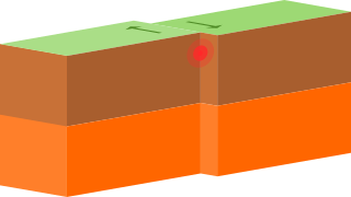
In geology, a fault is a planar fracture or discontinuity in a volume of rock across which there has been significant displacement as a result of rock-mass movements. Large faults within Earth's crust result from the action of plate tectonic forces, with the largest forming the boundaries between the plates, such as the megathrust faults of subduction zones or transform faults. Energy release associated with rapid movement on active faults is the cause of most earthquakes. Faults may also displace slowly, by aseismic creep.

Subsidence is a general term for downward vertical movement of the Earth's surface, which can be caused by both natural processes and human activities. Subsidence involves little or no horizontal movement, which distinguishes it from slope movement.

A convergent boundary is an area on Earth where two or more lithospheric plates collide. One plate eventually slides beneath the other, a process known as subduction. The subduction zone can be defined by a plane where many earthquakes occur, called the Wadati–Benioff zone. These collisions happen on scales of millions to tens of millions of years and can lead to volcanism, earthquakes, orogenesis, destruction of lithosphere, and deformation. Convergent boundaries occur between oceanic-oceanic lithosphere, oceanic-continental lithosphere, and continental-continental lithosphere. The geologic features related to convergent boundaries vary depending on crust types.

In geology, a rift is a linear zone where the lithosphere is being pulled apart and is an example of extensional tectonics.
Megathrust earthquakes occur at convergent plate boundaries, where one tectonic plate is forced underneath another. The earthquakes are caused by slip along the thrust fault that forms the contact between the two plates. These interplate earthquakes are the planet's most powerful, with moment magnitudes (Mw) that can exceed 9.0. Since 1900, all earthquakes of magnitude 9.0 or greater have been megathrust earthquakes.

The Manila Trench is an oceanic trench in the Pacific Ocean, located west of the islands of Luzon and Mindoro in the Philippines. The trench reaches a depth of about 5,400 metres (17,700 ft), in contrast with the average depth of the South China Sea of about 1,500 metres (4,900 ft). It is created by subduction, in which the Sunda Plate is subducting under the Philippine Mobile Belt, producing this almost N-S trending trench. The convergent boundary is terminated to the north by the Taiwan collision zone, and to the south by the Mindoro terrane. It is an area pervaded by negative gravity anomalies.
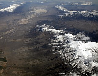
Basin and range topography is characterized by alternating parallel mountain ranges and valleys. It is a result of crustal extension due to mantle upwelling, gravitational collapse, crustal thickening, or relaxation of confining stresses. The extension results in the thinning and deformation of the upper crust, causing it to fracture and create a series of long parallel normal faults. This results in block faulting, where the blocks of rock between the normal faults either subside, uplift, or tilt. The movement of these blocks results in the alternating valleys and mountains. As the crust thins, it also allows heat from the mantle to more easily melt rock and form magma, resulting in increased volcanic activity.

The geology of China consists of three Precambrian cratons surrounded by a number of orogenic belts. The modern tectonic environment is dominated by the continued collision of India with the rest of Asia starting 40–50 million years ago. This has formed the Himalaya and continues to deform most of China. China has vast mineral reserves, a significant earthquake risk in its Western regions and rare isolated active volcanoes throughout the country.

The Puget Sound faults under the heavily populated Puget Sound region of Washington state form a regional complex of interrelated seismogenic (earthquake-causing) geologic faults. These include the:

The base of rocks that underlie Borneo, an island in Southeast Asia, was formed by the arc-continent collisions, continent–continent collisions and subduction–accretion due to convergence between the Asian, India–Australia, and Philippine Sea-Pacific plates over the last 400 million years. The active geological processes of Borneo are mild as all of the volcanoes are extinct. The geological forces shaping SE Asia today are from three plate boundaries: the collisional zone in Sulawesi southeast of Borneo, the Java-Sumatra subduction boundary and the India-Eurasia continental collision.

Hainan Island, located in the South China Sea off the Chinese coast and separated from mainland China by the Qiongzhou Strait, has a complex geological history that it has experienced multiple stages of metamorphism, volcanic and intrusive activities, tectonic drifting and more. The oldest rocks, the Proterozoic metamorphic basement, are not widely exposed, but mostly found in the western part of the Island.
The 1976 Longling earthquake in Yunnan Province, People's Republic of China, was a doublet earthquake, with two main shocks striking just east of Longling at 12:23:20 and 14:00:22 UTC. The magnitudes were estimated at 6.7 and 6.6, respectively, on the Mw(GCMT) scale, and 6.9 and 7.0 on the Ms scale; Chinese sources put these at 7.4 and 7.3 on the Ms7 scale. The region is noted for the quantity and intensity of its earthquakes, and the complexity of its tectonics, which are closely related to the collision between the Indian and Eurasian tectonic plates.
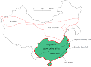
The South China Craton or South China Block is one of the Precambrian continental blocks in China. It is traditionally divided into the Yangtze Block in the NW and the Cathaysia Block in the SE. The Jiangshan–Shaoxing Fault represents the suture boundary between the two sub-blocks. Recent study suggests that the South China Block possibly has one more sub-block which is named the Tolo Terrane. The oldest rocks in the South China Block occur within the Kongling Complex, which yields zircon U–Pb ages of 3.3–2.9 Ga.
The Superior Craton is a stable crustal block covering Quebec, Ontario, and southeast Manitoba in Canada, and northern Minnesota in the United States. It is the biggest craton among those formed during the Archean period. A craton is a large part of the Earth's crust that has been stable and subjected to very little geological changes over a long time. The size of Superior Craton is about 1,572,000 km2. The craton underwent a series of events from 4.3 to 2.57 Ga. These events included the growth, drifting and deformation of both oceanic and continental crusts.

Oblique subduction is a form of subduction for which the convergence direction differs from 90° to the plate boundary. Most convergent boundaries involve oblique subduction, particularly in the Ring of Fire including the Ryukyu, Aleutian, Central America and Chile subduction zones. In general, the obliquity angle is between 15° to 30°. Subduction zones with high obliquity angles include Sunda trench and Ryukyu arc.
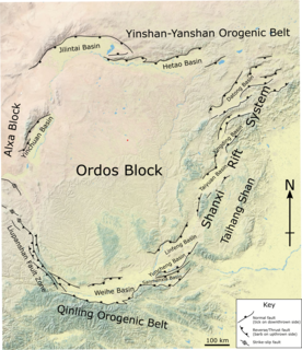
The Ordos Block is a crustal block, that forms part of the larger North China Block (NCB). It is surrounded by active fault systems and has been a distinct block since at least the Mesozoic. It is bordered to the west by the Alxa Block, the westernmost part of the NCB, to the south by the Qinling orogenic belt, to the north by the Yanshan-Yinshan orogenic belt, part of the Central Asian Orogenic Belt and to the east by the Taihangshan mountain range, which forms part of the Trans-North China Orogen. The block is currently stable and large earthquakes are restricted to the bordering fault zones. It has been suggested that the block is currently undergoing anti-clockwise rotation with respect to the Eurasian Plate, as a result of the ongoing eastward spreading of the Tibetan Plateau, although this view has been challenged.
References
- ↑ Flinn, D. (1 May 2009). "A Tectonic Analysis of the Muness Phyllite Block of Unst and Uyea, Shetland". Geological Magazine. 89 (4): 263–272. doi:10.1017/S0016756800067741.
- ↑ Faure, Michel; Lepvrier, Claude; Nguyen, Vuong Van; Vu, Tich Van; Lin, Wei; Chen, Zechao (January 2014). "The South China block-Indochina collision: Where, when, and how?". Journal of Asian Earth Sciences. 79: 260–274. doi:10.1016/j.jseaes.2013.09.022.
- ↑ Gilbert, G. K. (1909). "Earthquake Forecasts". Science. 29 (734): 121–138. doi:10.1126/science.29.734.121. JSTOR 1635153. PMID 17730301.
- ↑ McCaffrey, R.; Bird, P.; Bormann, J.; Haller, K.M.; Hammond, W.C.; Thatcher, W.; Wells, R.E.; Zeng, Y. "Appendix A—NSHMP Block Model of Western United States Active Tectonics" (PDF). pp. 27–47.
| | This tectonics article is a stub. You can help Wikipedia by expanding it. |