Related Research Articles

The Basin and Range Province is a vast physiographic region covering much of the inland Western United States and northwestern Mexico. It is defined by unique basin and range topography, characterized by abrupt changes in elevation, alternating between narrow faulted mountain chains and flat arid valleys or basins. The physiography of the province is the result of tectonic extension that began around 17 million years ago in the early Miocene epoch.

In geology, a rift is a linear zone where the lithosphere is being pulled apart and is an example of extensional tectonics.

The Wilson Cycle is a model that describes the opening and closing of ocean basins and the subduction and divergence of tectonic plates during the assembly and disassembly of supercontinents. A classic example of the Wilson Cycle is the opening and closing of the Atlantic Ocean. It has been suggested that Wilson cycles on Earth started about 3 Ga in the Archean Eon. The Wilson Cycle model was a key development in the theory of plate tectonics during the Plate Tectonics Revolution.

A foreland basin is a structural basin that develops adjacent and parallel to a mountain belt. Foreland basins form because the immense mass created by crustal thickening associated with the evolution of a mountain belt causes the lithosphere to bend, by a process known as lithospheric flexure. The width and depth of the foreland basin is determined by the flexural rigidity of the underlying lithosphere, and the characteristics of the mountain belt. The foreland basin receives sediment that is eroded off the adjacent mountain belt, filling with thick sedimentary successions that thin away from the mountain belt. Foreland basins represent an endmember basin type, the other being rift basins. Space for sediments is provided by loading and downflexure to form foreland basins, in contrast to rift basins, where accommodation space is generated by lithospheric extension.
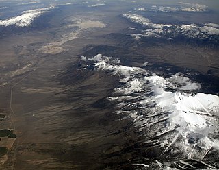
Basin and range topography is characterized by alternating parallel mountain ranges and valleys. It is a result of crustal extension due to mantle upwelling, gravitational collapse, crustal thickening, or relaxation of confining stresses. The extension results in the thinning and deformation of the upper crust, causing it to fracture and create a series of long parallel normal faults. This results in block faulting, where the blocks of rock between the normal faults either subside, uplift, or tilt. The movement of these blocks results in the alternating valleys and mountains. As the crust thins, it also allows heat from the mantle to more easily melt rock and form magma, resulting in increased volcanic activity.
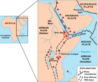
The Afar Triple Junction is located along a divergent plate boundary dividing the Nubian, Somali, and Arabian plates. This area is considered a present-day example of continental rifting leading to seafloor spreading and producing an oceanic basin. Here, the Red Sea Rift meets the Aden Ridge and the East African Rift. The latter extends a total of 6,500 kilometers (4,000 mi) from the Afar Triangle to Mozambique.
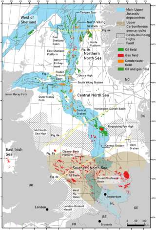
The geology of the North Sea describes the geological features such as channels, trenches, and ridges today and the geological history, plate tectonics, and geological events that created them.

In the geology of the Philippines, the Philippine Mobile Belt is a complex portion of the tectonic boundary between the Eurasian Plate and the Philippine Sea Plate, comprising most of the country of the Philippines. It includes two subduction zones, the Manila Trench to the west and the Philippine Trench to the east, as well as the Philippine Fault System. Within the Belt, a number of crustal blocks or microplates which have been shorn off the adjoining major plates are undergoing massive deformation.

The Andean orogeny is an ongoing process of orogeny that began in the Early Jurassic and is responsible for the rise of the Andes mountains. The orogeny is driven by a reactivation of a long-lived subduction system along the western margin of South America. On a continental scale the Cretaceous and Oligocene were periods of re-arrangements in the orogeny. The details of the orogeny vary depending on the segment and the geological period considered.

The island of Taiwan was formed approximately 4 to 5 million years ago at a convergent boundary between the Philippine Sea Plate and the Eurasian Plate. In a boundary running the length of the island and continuing southwards, the Eurasian Plate is sliding under the Philippine Sea Plate. In the northeast of the island, the Philippine Sea Plate slides under the Eurasian Plate. Most of the island comprises a huge fault block tilted to the west.

The Yinggehai-Song Hong Basin is located on the northwest of the South China Sea, between Hainan island and the coast of northern Vietnam. It is a large extensional pull-part basin in extensional continental marginal setting, developed along the Red River fault zone, which located at the suture of the Indochina Plate and Yangtze Plate.
The Pearl River Mouth basin (PRMB) is an extensional sedimentary basin located in the northern part of the South China Sea. The basin covers an area of about 175,000 km2 where the Pearl River meets the South China Sea near Hong Kong.

The Adare Basin is a geologic structural basin located north-east of Cape Adare of Antarctica, for which its named, and north of the western Ross Sea. The Adare Basin is an extensional rift basin located along a seafloor spreading center that forms the failed arm of the Tertiary spreading ridge separating East and West Antarctica, known as the West Antarctic Rift System and similar in structure to the East Africa Rift System. Centrally located in the Adare Basin is the Adare Trough. The extension of this rift system is recorded in a series of magnetic anomalies which run along the seafloor at the extinct, north–south trending, Adare spreading axis. The Adare spreading system continues unbroken into the Northern Basin underlying the adjacent Ross Sea continental shelf.

The North German Basin is a passive-active rift basin located in central and west Europe, lying within the southeasternmost portions of the North Sea and the southwestern Baltic Sea and across terrestrial portions of northern Germany, Netherlands, and Poland. The North German Basin is a sub-basin of the Southern Permian Basin, that accounts for a composite of intra-continental basins composed of Permian to Cenozoic sediments, which have accumulated to thicknesses around 10–12 kilometres (6–7.5 mi). The complex evolution of the basin takes place from the Permian to the Cenozoic, and is largely influenced by multiple stages of rifting, subsidence, and salt tectonic events. The North German Basin also accounts for a significant amount of Western Europe's natural gas resources, including one of the world's largest natural gas reservoir, the Groningen gas field.

The Kutai sedimentary basin extends from the central highlands of Borneo, across the eastern coast of the island and into the Makassar Strait. With an area of 60,000 km2, and depths up to 15 km, the Kutai is the largest and deepest Tertiary age basin in Indonesia. Plate tectonic evolution in the Indonesian region of SE Asia has produced a diverse array of basins in the Cenozoic. The Kutai is an extensional basin in a general foreland setting. Its geologic evolution begins in the mid Eocene and involves phases of extension and rifting, thermal sag, and isostatic subsidence. Rapid, high volume, sedimentation related to uplift and inversion began in the Early Miocene. The different stages of Kutai basin evolution can be roughly correlated to regional and local tectonic events. It is also likely that regional climate, namely the onset of the equatorial ever wet monsoon in early Miocene, has affected the geologic evolution of Borneo and the Kutai basin through the present day. Basin fill is ongoing in the lower Kutai basin, as the modern Mahakam River delta progrades east across the continental shelf of Borneo.

The base of rocks that underlie Borneo, an island in Southeast Asia, was formed by the arc-continent collisions, continent–continent collisions and subduction–accretion due to convergence between the Asian, India–Australia, and Philippine Sea-Pacific plates over the last 400 million years. The active geological processes of Borneo are mild as all of the volcanoes are extinct. The geological forces shaping SE Asia today are from three plate boundaries: the collisional zone in Sulawesi southeast of Borneo, the Java-Sumatra subduction boundary and the India-Eurasia continental collision.
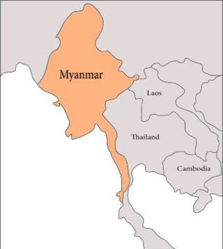
The geology of Myanmar is shaped by dramatic, ongoing tectonic processes controlled by shifting tectonic components as the Indian plate slides northwards and towards Southeast Asia. Myanmar spans across parts of three tectonic plates separated by north-trending faults. To the west, a highly oblique subduction zone separates the offshore Indian plate from the Burma microplate, which underlies most of the country. In the center-east of Myanmar, a right lateral strike slip fault extends from south to north across more than 1,000 km (620 mi). These tectonic zones are responsible for large earthquakes in the region. The India-Eurasia plate collision which initiated in the Eocene provides the last geological pieces of Myanmar, and thus Myanmar preserves a more extensive Cenozoic geological record as compared to records of the Mesozoic and Paleozoic eras. Myanmar is physiographically divided into three regions: the Indo-Burman Range, Myanmar Central Belt and the Shan Plateau; these all display an arcuate shape bulging westwards. The varying regional tectonic settings of Myanmar not only give rise to disparate regional features, but they also foster the formation of petroleum basins and a diverse mix of mineral resources.
The geology of Sicily records the collision of the Eurasian and the African plates during westward-dipping subduction of the African slab since late Oligocene. Major tectonic units are the Hyblean foreland, the Gela foredeep, the Apenninic-Maghrebian orogen, and the Calabrian Arc. The orogen represents a fold-thrust belt that folds Mesozoic carbonates, while a major volcanic unit is found in an eastern portion of the island. The collision of Africa and Eurasia is a retreating subduction system, such that the descending Africa is falling away from Eurasia, and Eurasia extends and fills the space as the African plate falls into the mantle, resulting in volcanic activity in Sicily and the formation of Tyrrhenian slab to the north.
Kapuni is an onshore natural gas-condensate field located in the Taranaki Basin, a ~100,000 km2 partially-inverted rift basin on the Taranaki Peninsula in the North Island, New Zealand. Discovered in 1959 and brought into production in 1970, Kapuni remained New Zealand's only producing gas-condensate field until the offshore Maui gas field began production in 1979.

The subduction tectonics of the Philippines is the control of geology over the Philippine archipelago. The Philippine region is seismically active and has been progressively constructed by plates converging towards each other in multiple directions. The region is also known as the Philippine Mobile Belt due to its complex tectonic setting.
References
- 1 2 Clift, P. D.; Lin, J. (2001). "Preferential mantle lithospheric extension under the South China margin". Marine and Petroleum Geology . 18 (8): 929–945. doi:10.1016/S0264-8172(01)00037-X.
- ↑ Taylor, B.; Hayes, D.E. (1980). "The tectonic evolution of the South China Sea Basin". The Tectonic and Geologic Evolution of Southeast Asian Seas and Islands. pp. 89–104. doi:10.1029/GM023p0089. ISBN 978-0-87590-023-0.
- ↑ Thies, K.; Mansor, A.; Hamdon, M.; Bishkel, R.; Boyer, J.; Tearpock, D. (2006). "Structural and Stratigraphic Development of Extensional Basins: A Case Study Offshore Deepwater Sarawak and Northwest Sabah Malaysia" (PDF). Search and Discovery 10103.
- ↑ Fyhn, Michael B.W.; Boldreel, Lars O.; Nielsen, Lars H. (2009). "Geological development of the central and south Vietnamese margin: Implication for the establishment of the South China Sea, Indochinese escape tectonics and Cenozoic volcanism". Tectonophysics . 460 (3–4): 83–93. Bibcode:2009Tectp.478..184F. doi:10.1016/j.tecto.2009.08.002.
- ↑ Hsu, Shu-Kun; Yeh, Yi-Ching; Doo, Wen-Bin; Tsai, Ching-Hui (2004). "New Bathymetry and Magnetic Lineations Identifications in the Northernmost South China Sea and their Tectonic Implications". Marine Geophysical Researches. 25 (1–2): 29–44. Bibcode:2004MarGR..25...29H. doi:10.1007/s11001-005-0731-7. S2CID 73718843.
- 1 2 Wang, Pinxian; Li, Qianyu (2009). The South China Sea: Paleoceanography and Sedimentology. Springer Science & Business Media. ISBN 978-1-4020-9745-4.
- 1 2 3 Cullen, Andrew; Reemst, Paul; Henstra, Gijs; Gozzard, Simon; Ray, Anandaroop (2010). "Rifting of the South China Sea: New perspectives". Petroleum Geoscience. 16 (3): 273–282. doi:10.1144/1354-079309-908. S2CID 27168015.
- ↑ Yan, Quanshu; Shi, Xuefa; Liu, Jihua; Wang, Kunshan; Bu, Wenrui (2010). "Petrology and geochemistry of Mesozoic granitic rocks from the Nansha micro-block, the South China Sea: Constraints on the basement nature". Journal of Asian Earth Sciences. 37 (2): 130–139. Bibcode:2010JAESc..37..130Y. doi:10.1016/j.jseaes.2009.08.001.
- ↑ Fuller, Mike; Ali, Jason R; Moss, Steve J; Frost, Gina Marie; Richter, Bryan; Mahfi, Achmad (1999). "Paleomagnetism of Borneo". Journal of Asian Earth Sciences. 17 (1–2): 3–24. Bibcode:1999JAESc..17....3F. doi:10.1016/S0743-9547(98)00057-9. ISSN 1367-9120.
- ↑ Hutchison, C.S.; Bergman, S.C.; Swauger, D.; Graves, J.E. (2000). "A Miocene collisional belt in north Borneo, uplift mechanism and isotatic adjustment quantified by thermochronology". Journal of the Geological Society. 157 (4): 783–793. Bibcode:2000JGSoc.157..783H. doi:10.1144/jgs.157.4.783. S2CID 131353015.
- ↑ Hall, R. (1997). "Cenozoic plate reconstructions of SE Aisa". Tectonic Evolution of Southeast Asia (106): 153–184.
- ↑ Hall, R, Robert (2002). "Cenozoic geological and plate tectonic evolution of SE Asia and the SW Pacific: computer-based reconstructions, model and animations". Journal of Asian Earth Sciences. 20 (4): 353–431. Bibcode:2002JAESc..20..353H. doi:10.1016/S1367-9120(01)00069-4.
- ↑ Higg, R (1999). "Gravity anomalies, subsidence history and the tectonic evolution of the Malay and Penyu Basins (offshore Peninsula Malaysia)". Basin Research. 11 (3): 285–290. Bibcode:1999BasR...11..285H. doi:10.1046/j.1365-2117.1999.00099.x. S2CID 130723667.
- ↑ Gong, Z.; Li, S. (1997). "Continental Margin Basin Analysis and Hydrocarbon Accumulation of the Northern South China Sea". China Sci. Press: 510.
- 1 2 3 4 Z.S. Gong , L. F. Huang and P. H. Chen (2011) NEOTECTONIC CONTROLS ON PETROLEUM ACCUMULATIONS, OFFSHORE CHINA, Journal of Petroleum Geology, Vol. 34(1), pp 1- 24
- ↑ McKENZIE, D. P.(1978) Some remarks on the development of sedimentary basins. Earth and Planetary Science Letters, 40, 25–32.
- 1 2 FYHN, M.B. W., NIELSEN, L. H., BOLDREEL, L. O., THANG,L. D., BOJESEN-KOEFOED, J., PETERSEN, H. I, HUYEN, N. T., DUC, N. A., DAU, N. T., MATHIESEN, A., REID, I., HUONG, D., T., TUAN, H. A., HIEN, L. V., NYTOFT, H. T., and ABATZIS, I., 2009. Geological evolution, regional perspectives and hydrocarbon potential of the northwest Phu Khanh Basin, offshore Central Vietnam. Marine Petrol Geol., 26, 1-24
- ↑ CHEN, P.H., CHEN, Z.Y. and ZHANG, Q.M., 1993. Sequence stratigraphy and continental margin development of the northwestern shelf of the South China Sea. AAPG Bull., 77(5), 842-862
- ↑ Rangin et al., 1995; RANGIN, C., KLEIN, M., ROQUES, D., LE PICHON, X. and TRONG L.V., 1995. The Red River fault system in the Tonkin Gulf, Vietnam. Tectonophysics, 243, 209–222.
- ↑ GILLEY, L. D., HARRISON, T. M., LELOUP, P. H., RYERSON, F. J., LOVERA, O. M. and WANG J. H., 2003. Direct dating of left-lateral deformation along the Red River shear zone, China and Vietnam. Jour. Geophys. Res., 108(B2), 1401-1421
- ↑ ZHU, M.H., GRAHAM, S. and McHARGUE, T., 2009. The Red River Fault Zone in the Yinggehai Basin, South China Sea. Tectonophysics, 476(3), 397-417