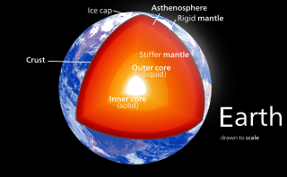
In geology, the crust is the outermost solid shell of a rocky planet, dwarf planet, or natural satellite. It is usually distinguished from the underlying mantle by its chemical makeup; however, in the case of icy satellites, it may be distinguished based on its phase.

The Iapetus Ocean was an ocean that existed in the late Neoproterozoic and early Paleozoic eras of the geologic timescale. The Iapetus Ocean was situated in the southern hemisphere, between the paleocontinents of Laurentia, Baltica and Avalonia. The ocean disappeared with the Acadian, Caledonian and Taconic orogenies, when these three continents joined to form one big landmass called Euramerica. The "southern" Iapetus Ocean has been proposed to have closed with the Famatinian and Taconic orogenies, meaning a collision between Western Gondwana and Laurentia.

Eclogite is a metamorphic rock containing garnet (almandine-pyrope) hosted in a matrix of sodium-rich pyroxene (omphacite). Accessory minerals include kyanite, rutile, quartz, lawsonite, coesite, amphibole, phengite, paragonite, zoisite, dolomite, corundum and, rarely, diamond. The chemistry of primary and accessory minerals is used to classify three types of eclogite. The broad range of eclogitic compositions has led a longstanding debate on the origin of eclogite xenoliths as subducted, altered oceanic crust.
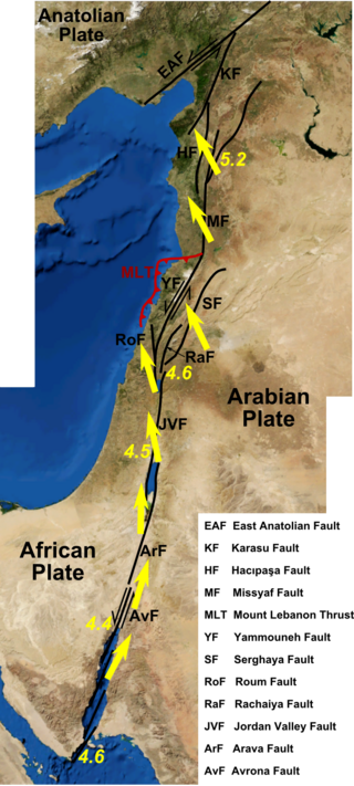
The Dead Sea Transform (DST) fault system, also sometimes referred to as the Dead Sea Rift, is a series of faults that run for about 1,000 km from the Maras Triple Junction to the northern end of the Red Sea Rift. The fault system forms the transform boundary between the African Plate to the west and the Arabian Plate to the east. It is a zone of left lateral (sinistral) displacement, signifying the relative motions of the two plates. Both plates are moving in a general north-northeast direction, but the Arabian Plate is moving faster, resulting in the observed left lateral motions along the fault of approximately 107 km at its southern end. A component of extension is also present in the southern part of the transform, which has contributed to a series of depressions, or pull-apart basins, forming the Gulf of Aqaba, Dead Sea, Sea of Galilee, and Hula basins. A component of shortening affects the Lebanon restraining bend, leading to uplift on both sides of the Beqaa valley. There is local transtension in the northernmost part of the fault system, forming the Ghab pull-apart basin. The fault system runs roughly along the political border of Israel, Jordan, and Lebanon.

Peter Alfred Ziegler was a Swiss geologist, who made contributions to the understanding of the geological evolution of Europe and the North Atlantic borderlands, of intraplate tectonics and of plate tectonic controls on the evolution and hydrocarbon potential of sedimentary basins. Ziegler's career consists of 33 years as exploration geologist with the petroleum industry, 30 of which with Shell, and 20 years of university teaching and research.
The Greenland Plate is a supposed tectonic plate bounded to the west by Nares Strait, a probable transform fault; on the southwest by the Ungava transform underlying Davis Strait; on the southeast by the Mid-Atlantic Ridge; and the northeast by the Gakkel Ridge, with its northwest border still being explored. The Greenland craton is made up of some of the oldest rocks on Earth. The Isua greenstone belt in southwestern Greenland contains the oldest known rocks on Earth dated at 3.7–3.8 billion years old.

The Iberian Plate is a microplate typically grouped with the Eurasian Plate that includes the microcontinent Iberia, Corsica, Sardinia, the Balearic Islands, the Briançonnais zone of the Penninic nappes of the Alps, and the portion of Morocco north of the High Atlas Mountains. The Iberian plate is a part of the Eurasian plate.
Martin Litherland OBE is a geologist who has travelled and published widely.
A whiteschist is an uncommon metamorphic rock formed at high to ultra-high pressures. It has the characteristic mineral assemblage of kyanite + talc, responsible for its white colour. The name was introduced in 1973 by German mineralogist and petrologist Werner Schreyer. This rock is associated with the metamorphism of some pelites, evaporite sequences or altered basaltic or felsic intrusions. Whiteschists form in the MgO–Fe
2O
3–Al
2O
3–SiO
2–H
2O (MFASH) system. Rocks of this primary chemistry are extremely uncommon and they are in most cases thought to be the result of metasomatic alteration, with the removal of various mobile elements.
The Main Uralian Fault (MUF) runs north–south through the middle of the Ural Mountains for over 2,000 km. It separates both Europe from Asia and the three, or four, western megazones of the Urals from the three eastern megazones: namely the Pre-Uralian Foredeep, West Uralian, and the Central Uralian to the west, and the Tagil-Magnitogorskian, East Uralian, and Transuralian to the east. The Russian Plate is often included as the fourth megazone to the west. On the west side of the fault the rocks represent the sediments of the eastern continental margin zone of the European Plate (Baltica). On the east the rocks are accreted oceanic and island arc basalts, ultramafics and volcanics as well as the sediments of the western continental margin zones of the Siberian craton on the north and the Kazakhstan craton on the south.

Solimana is a volcanic massif in the Andes of Peru, South America, that is approximately 6,093 metres (19,990 ft) high. It is considered an extinct stratovolcano that is part of the Central Volcanic Zone, one of the volcanic belts of the Andes. It features a caldera as well as traces of a sector collapse and subsequent erosion. The volcano is glaciated.

Subduction polarity reversal is a geologic process in which two converging plates switch roles: The over-lying plate becomes the down-going plate, and vice versa. There are two basic units which make up a subduction zone. This consists of an overriding plate and the subduction plate. Two plates move towards each other due to tectonic forces. The overriding plate will be on the top of the subducting plate. This type of tectonic interaction is found at many plate boundaries.

The Scandinavian Caledonides are the vestiges of an ancient, today deeply eroded orogenic belt formed during the Silurian–Devonian continental collision of Baltica and Laurentia, which is referred to as the Scandian phase of the Caledonian orogeny. The size of the Scandinavian Caledonides at the time of their formation can be compared with the size of the Himalayas. The area east of the Scandinavian Caledonides, including parts of Finland, developed into a foreland basin where old rocks and surfaces were covered by sediments. Today, the Scandinavian Caledonides underlay most of the western and northern Scandinavian Peninsula, whereas other parts of the Caledonides can be traced into West and Central Europe as well as parts of Greenland and eastern North America.
This is a compilation of the properties of different analog materials used to simulate deformational processes in structural geology. Such experiments are often called analog or analogue models. The organization of this page follows the review of rock analog materials in structural geology and tectonics of Reber et al. 2020.
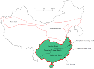
The South China Craton or South China Block is one of the Precambrian continental blocks in China. It is traditionally divided into the Yangtze Block in the NW and the Cathaysia Block in the SE. The Jiangshan–Shaoxing Fault represents the suture boundary between the two sub-blocks. Recent study suggests that the South China Block possibly has one more sub-block which is named the Tolo Terrane. The oldest rocks in the South China Block occur within the Kongling Complex, which yields zircon U–Pb ages of 3.3–2.9 Ga.

The subduction tectonics of the Philippines is the control of geology over the Philippine archipelago. The Philippine region is seismically active and has been progressively constructed by plates converging towards each other in multiple directions. The region is also known as the Philippine Mobile Belt due to its complex tectonic setting.

The Western Block of the North China Craton is an ancient micro-continental block mainly composed of Neoarchean and Paleoproterozoic rock basement, with some parts overlain by Cambrian to Cenozoic volcanic and sedimentary rocks. It is one of two sub-blocks within the North China Craton, located in east-central China. The boundaries of the Western Block are slightly different among distinct models, but the shapes and areas are similar. There is a broad consensus that the Western Block covers a large part of the east-central China.

Julia Ann “Jan” Tullis is an American structural geologist and emerita Professor at Brown University. Tullis is known for her work in structural geology, especially for her experimental work in deformation mechanisms, microstructures, and rheology of crustal rocks.

The East Luzon Trough is an oceanic trench north of the Philippine Trench and east of the island of Luzon. The trench is located near the Philippine orogeny and located in the southeastern region of the Philippine Sea Plate. The depth of the trough is 5,700 meters. The East Luzon Trough formed during the Eocene and Oligocene epoch, 40–24 million years ago.