Telopea Park

Last updated

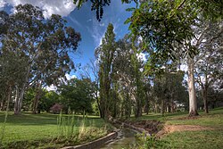
Telopea Park viewed along the stormwater drain from south to north Views of Telopea Park in Canberra IMG 8566 ff StrongDefault.jpg
Telopea Park viewed along the stormwater drain from south to north

Telopea Park is one of the oldest parks in Canberra, Australia. The name of the park is from Walter Burley Griffin's original plan for Canberra where he planned Telopea Park at the end of Sydney Avenue. The park is named after the floral emblem of New South Wales, also known as the Waratah. Griffin planned that the state capital city avenues were terminated with a park named after the generic botanical name for a native plant from that particular state. The park covers 0.079 km². [1]

Canberra capital city of Australia

Canberra is the capital city of Australia. With a population of 410,301, it is Australia's largest inland city and the eighth-largest city overall. The city is located at the northern end of the Australian Capital Territory (ACT), 280 km (170 mi) south-west of Sydney, and 660 km (410 mi) north-east of Melbourne. A resident of Canberra is known as a Canberran. Although Canberra is the capital and seat of government, many federal government ministries have secondary seats in state capital cities, as do the Governor-General and the Prime Minister.

Australia Country in Oceania

Australia, officially the Commonwealth of Australia, is a sovereign country comprising the mainland of the Australian continent, the island of Tasmania and numerous smaller islands. It is the largest country in Oceania and the world's sixth-largest country by total area. The neighbouring countries are Papua New Guinea, Indonesia and East Timor to the north; the Solomon Islands and Vanuatu to the north-east; and New Zealand to the south-east. The population of 25 million is highly urbanised and heavily concentrated on the eastern seaboard. Australia's capital is Canberra, and its largest city is Sydney. The country's other major metropolitan areas are Melbourne, Brisbane, Perth and Adelaide.

Walter Burley Griffin American architect and landscape architect

Walter Burley Griffin was an American architect and landscape architect. He is known for designing Canberra, Australia's capital city. He has been credited with the development of the L-shaped floor plan, the carport and an innovative use of reinforced concrete.

The park was established in 1922 and is very long and thin, with many large native and introduced trees. A stormwater drain runs along the middle of the park, which is crossed by several bridges. The park has barbecue areas and playground equipment, and is a popular destination. [1] It was listed by the ACT Heritage Council in 2012. [2]

Barbecue cooking method and apparatus

Barbecue or barbeque is a cooking method, a style of food, and a name for a meal or gathering at which this style of food is cooked and served.

The park is bounded by Telopea Park West (street) and Telopea Park East (street) on either side, with Manuka Oval at the southern end, across New South Wales crescent, and Bowen drive on the Northern End, near Lake Burley Griffin. The park is between the suburbs of Barton and Kingston close to Lake Burley Griffin.

Manuka Oval stadium in Canberra, Australian Capital Territory

Manuka Oval is a sporting venue in Canberra, the capital of Australia. It is located in Griffith, in the area of that suburb known as Manuka. Manuka Oval has a seating capacity of 13,550 people and an overall capacity of 16,000 people, although this is lower for some sports depending on the configuration used. The area on which the ground is situated has been used for sport since the early 20th century, but was only enclosed in 1929. It has since undergone several redevelopments, most recently beginning in 2011.

Lake Burley Griffin man-made lake in Canberra, Australia

Lake Burley Griffin is an artificial lake in the centre of Canberra, the capital of Australia. It was completed in 1963 after the Molonglo River—which ran between the city centre and Parliamentary Triangle—was dammed. It is named after Walter Burley Griffin, the American architect who won the competition to design the city of Canberra.

Barton, Australian Capital Territory Suburb of Canberra, Australian Capital Territory

Barton is a suburb of Canberra, Australian Capital Territory, Australia. At the 2016 census, Barton had a population of 1,439 people.

Related Research Articles

Australian Capital Territory Federal territory of Australia, containing the capital city, Canberra

The Australian Capital Territory is a federal territory of Australia, located in the south-east of the country and enclaved within the state of New South Wales. It contains Canberra, the capital city of Australia.

Molonglo River river in Australia

The Molonglo River, a perennial river that is part of the Murrumbidgee catchment within the Murray–Darling basin, is located in the Monaro and Capital Country regions of New South Wales and the Australian Capital Territory, in Australia.

Acton, Australian Capital Territory Suburb of Canberra, Australian Capital Territory

Acton is a suburb of Canberra, ACT, Australia. Acton covers an area west of the CBD, bordered by Black Mountain to the west and Lake Burley Griffin in the south. The Australian National University campus covers most of the suburb, though also located in Acton is the National Film and Sound Archive, a branch of the CSIRO and the National Museum of Australia.

Yarralumla, Australian Capital Territory Suburb of Canberra, Australian Capital Territory

Yarralumla is a large inner south suburb of Canberra, the capital city of Australia. Located approximately 3.5 kilometres (2.2 mi) south-west of the city, Yarralumla extends along the south-west bank of Lake Burley Griffin.

Braddon, Australian Capital Territory Suburb of Canberra, Australian Capital Territory

Braddon is an inner north suburb of Canberra, Australian Capital Territory, Australia located adjacent to the Canberra CBD.

Forrest, Australian Capital Territory Suburb of Canberra, Australian Capital Territory

Forrest is an affluent suburb of Canberra, Australian Capital Territory, Australia. Forrest is named after Sir John Forrest, an explorer, legislator, federalist, premier of Western Australia, and one of the fathers of the Australian Constitution. Streets in Forrest are named after explorers and governors. According to the Australian Bureau of Statistics Forrest is the second most Socio-Economic advantaged location in Australia after the neighbouring suburb of Barton.

Capital Hill, Australian Capital Territory Suburb of Canberra, Australian Capital Territory

Capital Hill, is the location of Parliament House, Canberra, at the south apex of the land axis of the Parliamentary Triangle.

Griffith, Australian Capital Territory Suburb of Canberra, Australian Capital Territory

Griffith is an early inner-south suburb of Canberra, Australian Capital Territory, Australia.

Kingston, Australian Capital Territory Suburb of Canberra, Australian Capital Territory

Kingston is the oldest and one of the most densely populated suburbs of Canberra, Australian Capital Territory, Australia. The suburb is named after Charles Cameron Kingston, the former Premier of South Australia and minister in the first Australian Commonwealth Government. It is adjacent to the suburbs of Barton, Fyshwick, Griffith and Manuka. The suburb of Kingston is situated about 4 km from the centre of Canberra.

Narrabundah, Australian Capital Territory Suburb of Canberra, Australian Capital Territory

Narrabundah is a leafy suburb of Canberra, Australian Capital Territory, located in the inner south of the city.

Parliamentary Triangle, Canberra ceremonial precinct of Canberra, Australia

The National Triangle, which is referred to as the Parliamentary Triangle, is the ceremonial precinct of Canberra, containing some of Australia's most significant buildings. The National Triangle is formed by Commonwealth, Kings and Constitution Avenues. Buildings within the National Triangle have been located and designed intentionally for visual effect, and those of national significance are popular tourist attractions.

City Hill, Canberra

City Hill is a park located in Canberra, Australia on one of the points of the Parliamentary Triangle, a feature of Walter Burley Griffin's plan for the city. The park is surrounded by Vernon Circle, at the south end of Northbourne Avenue but the precinct extends to London Circuit and is an integral part of the city centre design. To the south of the hill Northbourne Avenue becomes Commonwealth Avenue, and further along is Commonwealth Avenue bridge.

Kings Park, Canberra park in Canberra, Australia

Kings Park is a park in Canberra, Australia on the shore of Lake Burley Griffin.

Lennox Gardens

Lennox Gardens, a park in Canberra, Australia, lying on the south side of Lake Burley Griffin, close to Commonwealth Avenue Bridge and Albert Hall in the suburb of Yarralumla. Before the construction of Lake Burley Griffin a road ran through the present garden, this road being one of two main crossing points across the Molonglo River. The name of the road was Lennox Crossing from which the present garden takes its name. The northern segment of the road is still present on Acton peninsula. The garden was officially named in 1963. Lennox Crossing was named after David Lennox, an early bridge builder in NSW and Victoria.

Manuka, Australian Capital Territory neighbourhood of Canberra, Australia

Manuka is an area in the Inner South district of Canberra, Australia covering parts of the suburbs of Griffith and Forrest. Manuka Shops, Manuka Oval, Manuka Swimming Pool, and Manuka Circle take their name from the park in the area.

Kings Avenue, Canberra road in Canberra

Kings Avenue is a road in Canberra which goes between New Parliament House, across Lake Burley Griffin at the Kings Avenue Bridge, to Russell near the Australian-American Monument..

Jerrabomberra Creek, a partly perennial stream of the Murrumbidgee catchment within the Murray-Darling basin, is located in the Capital Country region spanning both New South Wales and the Australian Capital Territory, Australia.

References

  1. 1 2 "Telopea Park". ACT Territory and Municipal Services. Retrieved 15 March 2014.
  2. "Heritage (Decision about Registration for Telopea Park, Barton) Notice 2012" (PDF). ACT Heritage Council. 23 February 2012. Retrieved 15 March 2014.

Coordinates: 35°18′48″S149°8′20″E / 35.31333°S 149.13889°E / -35.31333; 149.13889

Geographic coordinate system Coordinate system

A geographic coordinate system is a coordinate system that enables every location on Earth to be specified by a set of numbers, letters or symbols. The coordinates are often chosen such that one of the numbers represents a vertical position and two or three of the numbers represent a horizontal position; alternatively, a geographic position may be expressed in a combined three-dimensional Cartesian vector. A common choice of coordinates is latitude, longitude and elevation. To specify a location on a plane requires a map projection.