Canberra is the capital city of Australia. Founded following the federation of the colonies of Australia as the seat of government for the new nation, it is Australia's largest inland city and the eighth-largest Australian city overall. The city is located at the northern end of the Australian Capital Territory at the northern tip of the Australian Alps, the country's highest mountain range. As of June 2023, Canberra's estimated population was 466,566.

Walter Burley Griffin was an American architect and landscape architect. He designed Canberra, Australia's capital city, the New South Wales towns of Griffith and Leeton, and the Sydney suburb of Castlecrag.

Lake Burley Griffin is an artificial lake in the centre of Canberra, the capital of Australia. It was completed in 1963 after the Molonglo River, which ran between the city centre and Parliamentary Triangle, was dammed. It is named after Walter Burley Griffin, the architect who won the competition to design the city of Canberra.

The Molonglo River is a perennial river that is part of the Murrumbidgee catchment within the Murray–Darling basin. It is located in the Monaro and Capital Country regions of New South Wales and the Australian Capital Territory, in Australia.

Acton is a suburb of Canberra, ACT, Australia. Acton covers an area west of the CBD, bordered by Black Mountain to the west and Lake Burley Griffin in the south. The Australian National University campus covers most of the suburb, though also located in Acton is the National Film and Sound Archive, a branch of the CSIRO and the National Museum of Australia.

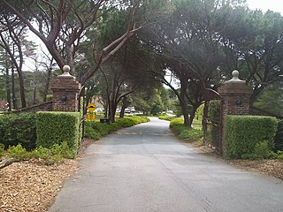
Yarralumla is a large inner south suburb of Canberra, the capital city of Australia. Located approximately 3.5 km (2.2 mi) south-west of the city, Yarralumla extends along the south-west bank of Lake Burley Griffin from Scrivener Dam to Commonwealth Avenue.

The National Carillon is a large carillon situated on Queen Elizabeth II Island in Lake Burley Griffin, central Canberra, in the Australian Capital Territory, Australia. The carillon is managed and maintained by the National Capital Authority on behalf of the Commonwealth of Australia. It has 57 bells, ranging nearly 5 octaves from the 6,108 kg (13,466 lb) bass bell in F# to the 8 kg (18 lb) treble bell in D.
The Canberra Golf Club, later known as the Royal Canberra Golf Club, was formed in 1926. Its original grounds were behind the Hotel Canberra on the river flats on both sides of the Molonglo River.
Anzac Parade is a significant road and thoroughfare in the Australian capital Canberra, used for ceremonial occasions and the site of many major military memorials.

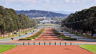
The National Triangle, also known as the Parliamentary Triangle, is the ceremonial precinct of Canberra, containing some of Australia's most significant buildings. The Triangle is formed by Commonwealth, Kings and Constitution Avenues. Buildings within the National Triangle have been located and designed intentionally for visual effect, and those of national significance are popular tourist attractions.

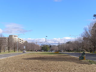
City Hill is a park located in Canberra, Australia, on one of the points of the Parliamentary Triangle, a feature of Walter Burley Griffin's plan for the city. The park is surrounded by Vernon Circle, at the south end of Northbourne Avenue, but beyond Vernon Circle it is further surrounded by the concentric London Circuit, and the area between Vernon Circle and London Circuit can also be seen as part of the hill. City Hill is an integral part of the city centre design. To the south of the hill Northbourne Avenue becomes Commonwealth Avenue, and further along is Commonwealth Avenue bridge.

Commonwealth Park is in Canberra, Australia, adjacent to the north side of Lake Burley Griffin. Centrally located in the city, it is an important part of the urban landscape. The park has an area of 34.25 hectares, which includes a variety of natural and constructed spaces.

Commonwealth Avenue is a major road in Canberra, Australian Capital Territory, Australia. It connects Civic with South Canberra. Specifically, it runs between City Hill and Capital Hill.
Kings Avenue is a road in Canberra which goes between New Parliament House, across Lake Burley Griffin at the Kings Avenue Bridge, to Russell near the Australian-American Monument..

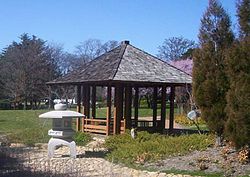
The Canberra Peace Park or Peace Park is beside Lake Burley Griffin between the lake and the National Library of Australia, in Canberra, the national capital of Australia. It is not to be confused with the Canberra-Nara Peace Park nearby.

Canberra Central is a district in the Australian Capital Territory in Australia. Consisting of both the subdivisions of North Canberra and South Canberra. The district is subdivided into divisions (suburbs), sections and blocks. The district of Canberra Central lies entirely within the bounds of the city of Canberra, the capital city of Australia.

The history of Lake Burley Griffin, an artificial body of water in Canberra, the capital of Australia, is highly complex. Following its initial design in the 1910s, extensive political disputes occurred until it was finally built in the 1960s.
The Immigration Bridge was a proposed footbridge in Canberra, the capital of Australia. It was proposed that it be built between the National Museum of Australia and Lennox Gardens on the south shore of the West Basin of Lake Burley Griffin, in the centre of the city.
Scott's Crossing Road was a former roadway connecting north and south Canberra, across the Molonglo River floodplain. It was named after John Scott, who was an early settler in the region, and whose homestead was located at its southern end. It was submerged by the filling of Lake Burley Griffin.

The Commonwealth Avenue Bridge are two parallel pre-stressed concrete box girder road bridges that carry Commonwealth Avenue across Lake Burley Griffin, and connect Parkes and City in Canberra, Australia.