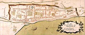
Ville-Marie is the name of a borough (arrondissement) in the centre of Montreal, Quebec. The borough is named after Fort Ville-Marie, the French settlement that would later become Montreal, which was located within the present-day borough. Old Montreal is a National Historic Site of Canada.

Côte-des-Neiges–Notre-Dame-de-Grâce is a borough (arrondissement) of Montreal, Quebec, Canada. The borough was created following the 2002 municipal reorganization of Montreal. It comprises two main neighbourhoods, Côte-des-Neiges and Notre-Dame-de-Grâce, both former towns that were annexed by the city of Montreal in 1910.

Mercier–Hochelaga-Maisonneuve is a borough of Montreal, Quebec, Canada located in the southeastern end of the island.

Le Sud-Ouest is a borough (arrondissement) of the city of Montreal, Quebec, Canada.

René Lévesque Boulevard, previously named Dorchester Boulevard is one of the main streets in Montreal, Quebec, Canada.

Saint Jacques Street, or St. James Street, is a major street in Montreal, Quebec, Canada, running from Old Montreal westward to Lachine.

Saint Denis Street is a major north–south thoroughfare in Montreal, Quebec.

The Notre-Dame-de-Bon-Secours Chapel is a church in the district of Old Montreal in Montreal, Quebec. One of the oldest churches in Montreal, it was built in 1771 over the ruins of an earlier chapel. The church is located at 400 Saint Paul Street East at Bonsecours Street, just north of the Bonsecours Market in the borough of Ville-Marie.

Sherbrooke Street is a major east–west artery and at 31.3 kilometres (19.4 mi) in length, is the second longest street on the Island of Montreal, Canada. The street begins in the town of Montreal West and ends on the extreme tip of the island in Pointe-aux-Trembles, intersecting Gouin Boulevard and joining up with Notre-Dame Street. East of Cavendish Boulevard this road is part of Quebec Route 138.

Rue Saint-Paul is a street in the Old Montreal historic area of Montreal, Quebec.

Notre-Dame Street is a historic east–west street located in Montreal, Quebec, Canada. It runs parallel to the Saint Lawrence River, from Lachine to the eastern tip of the island in Pointe-aux-Trembles, then continuing off the island into the Lanaudière region.

Saint Antoine Street, formerly known as Craig Street, is a street located in Montreal, Quebec, Canada. It runs to the south of Downtown Montreal and north of Old Montreal and Griffintown and Saint-Henri. It crosses the Quartier international de Montréal. Between Atwater Avenue and Greene Avenue, the north side of the street is in Westmount.
Pie-IX Boulevard, named after Pope Pius IX, is a major boulevard in Montreal, Quebec, Canada. It runs for roughly 11 km (6.8 mi) in a northwest–southeast direction between Henri Bourassa Boulevard and Notre-Dame East. Pie-IX Boulevard runs past the Montreal Botanical Gardens and the Olympic Stadium. The boulevard forms part of Quebec Route 125.

The Le Gardeur Bridge is a beam bridge that connects the east end of the island of Montreal, in Pointe-aux-Trembles, to Repentigny.
Metcalfe Street is a north–south street located in downtown Montreal, Quebec, Canada. It links Sherbrooke Street in the north and René Lévesque Boulevard in the south. It is best known for being the street on which the Sun Life Building, Mary, Queen of the World Cathedral, and other notable buildings are located. South of René Lévesque Boulevard, the street is known as Cathedral Street. The street borders the eastern side of both Dorchester Square and Place du Canada, to the south.

The Sir George-Étienne Cartier National Historic Site is a historic house museum located in the Old Montreal district, of Montreal, Quebec, Canada. It commemorates the life and accomplishments of Sir George-Étienne Cartier. This reconstitution of the adjoining homes of the Cartier family features the architectural heritage left by the upper middle class of 19th-century Montreal, along with interpretive activities and theatrical performances.

Laurier Avenue is a commercial and residential street in Montreal, Quebec, Canada. It crosses the boroughs of Outremont, Le Plateau-Mont-Royal and Rosemont–La Petite-Patrie. It is known for its cafés, restaurants and specialty stores, especially near Park Avenue and east of Sir Wilfrid Laurier Park.

Queen Mary Road is an east-west road located in Montreal, Quebec, Canada.

De L'Assomption Boulevard is a main north–south street in the Montreal boroughs of Mercier–Hochelaga-Maisonneuve, Rosemont–La Petite-Patrie and Saint-Léonard.

Côte-Sainte-Catherine Road is a street in Montreal, Quebec, Canada. It begins at the Décarie Expressway in Snowdon, part of the borough of Côte-des-Neiges–Notre-Dame-de-Grâce, and runs east and southeast along the periphery of Mount Royal to Park Avenue in the Plateau, terminating near Mount Royal Avenue. In between, it crosses Outremont completely and is one of the oldest streets in the borough, having been present at the time Outremont was incorporated in 1875. Outremont's borough hall is located on this street, as is Beaubien Park. Further west in Côte-des-Neiges, it houses the Jewish General Hospital, the CHU Sainte-Justine hospital, Collège Jean-de-Brébeuf, the Montreal Holocaust Museum, and the Segal Centre for Performing Arts.