The Crescent is a street in Taunton, a town in the English county of Somerset. Construction began in 1807, during a period of extensive redevelopment in the town, driven by the Market House Society and the Member of Parliament Sir Benjamin Hammet. Lined on the eastern side by a Georgian terrace, the street follows a shallow crescent shape, broken in the middle by Crescent Way and a bit further south by St George's Place. It links Upper High Street, at its southern end, with Park Street and Tower Street to the north. On the western side, Somerset County Council have their offices in the County Hall, erected in 1935, and extended in the 1960s. The Georgian terrace, the Masonic Hall, and the County Hall are recorded in the National Heritage List for England as listed buildings.
During the 17th and 18th centuries Taunton suffered, first due to the Civil War (1642–1651), during which two thirds of the town was burnt down,[1] and then the decline of the cloth industry upon which the town's economy relied.[2] In the late 18th century, the Taunton Market House Society formed with the aim of improving Taunton town centre, most notably the Market House.[3]Benjamin Hammet, a prominent member of the society, was elected as a Member of Parliament for Taunton in 1782, and tried to start clearing the slums in the town centre.[3] In 1770, the old Market House was knocked down and replaced,[4] and less than ten years later, Hammet Street was built, to connect the Market square with the Church of St Mary Magdalene.[5]
The Crescent formed part of Hammet's plan for Taunton. It was built to the north of Upper High Street, in what was known at the time as Paul's Field. It follows a shallow crescent shape, which Nikolaus Pevsner notes is "hardly noticeable".[6] Although Hammet died in 1800, the foundation stone was placed in 1807 by William Kinglake,[5] as part of a ceremony that was attended by "an immense number of persons."[7] The Monthly Magazine noted that the street was intended to add to the "ornament, respectability, and advantage" of Taunton,[7] while the Taunton Courier reported that the houses were intended for "genteel families".[8]
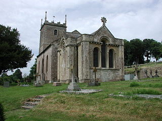
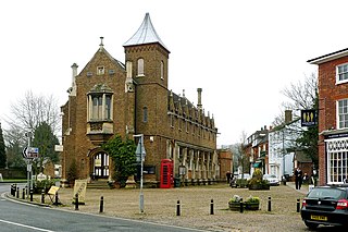
When the street was built, each end featured a cottage with high iron gates which limited traffic to residents and their visitors. The footpaths were less restricted, but featured "three or four posts between which a corpulent person had difficulty in squeezing."[8] These gates and posts have since been removed. The Crescent comprised a terrace of houses along the street's eastern side; the other side was not built on and was eventually converted into parkland.[5] In 1822, a Catholic chapel, known as St George's Chapel was built at the southern-end of the terrace, the first Catholic church built in Taunton since the Reformation.[9][10] The Catholic congregation moved out to a larger church in 1878 and the chapel was bought by the Freemasons, who converted it into a Masonic Lodge.[11]
In 1935, County Hall was built on the open side of The Crescent, providing Somerset County Council with more space than their previous offices at Shire Hall.[12] Early plans for further buildings at the site did not come to fruition, but County Hall was extended in the 1960s to cover most of the open land in front of The Crescent.[13] Despite the work done by Hammet, the area between The Crescent and the High Street was still considered a slum until it was redeveloped around the Second World War.[14] During this period, the General Post Office (GPO) built "Telephone House", a telephone exchange and office building, replacing the houses in the middle of the terrace.[6]
Architecture
The Masonic Hall, which was originally built as a Catholic chapel
On the eastern side of The Crescent, a Georgian terrace was erected in 1807. Built of "pinkish-brown" brick, each house is of three-storeys plus a basement, and is two windows across. The houses are split by plain pilasters and topped with hipped slate roofs. While the first and second storey windows are rectangular, those on the ground floor are round-headed, as are the doorways. The first floor windows have small, circular segmental balconies. A variety of six- and eight-panel doors are reached by climbing a small flight of steps, and the entire terrace is fronted with railings. This terrace forms two separate listed building designations from Historic England; numbers 1–11 and 15–20, both of which are Grade II* listed.[15][16]
The terrace is intersected by Crescent Way, which leads to the Crescent car park. On the southern side of Crescent Way, the northern end of the terrace formed by numbers 15–20, is Exchange House, the former GPO Telephone House, which was built in place of original numbers 12–14. According to Pevsner, this building breaks the modesty of the street, with "its thick-set Tuscan porch".[6] At the southern end of the same terrace is the Masonic Hall, another Grade II* listed building, which forms the end of the terrace, and features a series of prominent Ionicpilasters along the front and southern end.[17]
A further terrace to the south of the Masonic Hall is split from the hall by St George's Place. It is formed of numbers 21 to 23 The Crescent, and number 42 Upper High Street. The terrace forms two listed building designations, both Grade II. Numbers 21 and 22 The Crescent are two-storey roughcast houses, each spanning three windows. The doorways are round-headed, and are flanked by ground floor bay windows.[18] Number 23 forms the back of 42 Upper High Street, and is a two-storey red brick building.[19]
On the western side, the first part of the County Hall was built in 1935, and is known as "A Block". It was designed by Vincent Harris, and is Neo-Georgian. It is a three-storey, built out of red and buff-coloured bricks forming an English bond, with Portland stone dressings. The central section is curved, with wings at 45 degrees to the formed main entrance. The ground-floor is fronted with ashlar, and has three round arches, the middle one of which forms a doorway. The doorway is topped by an engraved coat of arms in the tympanum. The central block spans nine windows, while each wing has a prominent window at the end, framed by an aedicule. The first and second floors of the wings feature eleven sash windows. An extension was made to the south of the building in the 1960s. The original "A Block" is designated as a Grade II listed building.[13]
Taunton Castle is a castle built to defend the town of Taunton, Somerset, England. It has origins in the Anglo Saxon period and was later the site of a priory. The Normans then built a stone structured castle, which belonged to the Bishops of Winchester. The current heavily reconstructed buildings are the inner ward, which now houses the Museum of Somerset and the Somerset Military Museum. The building was designated a grade I listed building in 1952.
Marston Bigot is a small village in the civil parish of Trudoxhill, near Nunney and 3 miles (5 km) south of Frome in Somerset, England.
The Tudor Tavern at No 15 Fore Street, Taunton, Somerset, England has been designated as a Grade I listed building. Built in 1578, the house is three storeys high of a timber-frame construction, with jettied first and second floors. The frontage is of carved bressummers with interlocking curved braces, while the roof is red tiles. There is a medieval hall with an open trussed roof behind the front.
Norfolk Crescent in Bath, Somerset, England was built between c.1793 and c.1822 and has been designated as a Grade II* listed building. The original design was by John Palmer, but minor alterations were later made by John Pinch.
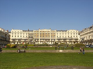
Royal Crescent is a crescent-shaped terrace of houses on the seafront in Brighton, part of the English city of Brighton and Hove. Built in the late 18th and early 19th century as a speculative development on the open cliffs east of Brighton by a wealthy merchant, the 14 lodging houses formed the town's eastern boundary until about 1820. It was the seaside resort's first planned architectural composition, and the first built intentionally to face the sea. The variety of building materials used include black glazed mathematical tiles—a characteristic feature of Brighton's 18th-century architecture. English Heritage has listed the crescent at Grade II* for its architectural and historical importance. An adjacent five-storey building, formerly the Royal Crescent Hotel but now converted into flats with the name Royal Crescent Mansions, is listed separately at Grade II.
Park Crescent is a mid-19th-century residential development in the Round Hill area of Brighton, part of the English city of Brighton and Hove. The horseshoe-shaped, three-part terrace of 48 houses was designed and built by one of Brighton's most important architects, Amon Henry Wilds; by the time work started in 1849 he had 35 years' experience in the town. Wilds used the Italianate style rather than his more common Regency motifs. Three houses were replaced after the Second World War because of bomb damage, and another was the scene of one of Brighton's notorious "trunk murders" of the 1930s. The three parts of the terrace, which encircle a private garden formerly a pleasure ground and cricket pitch, have been listed at Grade II* by English Heritage for their architectural and historical importance.
Regency Square is a large early 19th-century residential development on the seafront in Brighton, part of the British city of Brighton and Hove. Conceived by speculative developer Joshua Hanson as Brighton underwent its rapid transformation into a fashionable resort, the three-sided "set piece" of 69 houses and associated structures was built between 1818 and 1832. Most of the houses overlooking the central garden were complete by 1824. The site was previously known, briefly and unofficially, as Belle Vue Field.
The Freemasons Tavern is a 19th-century pub in the Brunswick Town area of Hove, part of the English city of Brighton and Hove. Built in the 1850s in a Classical style similar to the surrounding buildings in the rapidly growing Brunswick Town area, it was given a "spectacular" renovation when a restaurant was added in the 1920s. Local architecture firm Denman & Son designed an ornate Art Deco interior and an elaborate, brightly coloured entrance adorned with Masonic symbols; both the exterior and the interior survive in excellent condition. The tavern is a Grade II Listed building.
Barford Court is a care home operated by the Royal Masonic Benevolent Institution and situated on the seafront in Hove, part of the English city of Brighton and Hove. The building, completed in 1937, has had this function only since 1996; it was constructed by cinema architect Robert Cromie as a private house for Ian Stuart Millar, an eccentric iron industry tycoon, who occupied it for only nine years. The large building later accommodated the Brighton and Hove School of Nursing, which for the first time brought together training provision for all local hospitals' staff on one site. When the school moved away in 1989, the house spent several years on the market awaiting a buyer—and in steadily deteriorating structural condition—before being refurbished, extended, renamed and converted to its present use.
Roundhill Crescent is a late-19th-century housing development in Round Hill, an inner suburb of the English coastal city of Brighton and Hove. Partly developed in the 1860s with large terraced houses on a steeply sloping open hillside, the crescent—which "curves and changes height dramatically along its length"—was finished two decades later and now forms the centrepiece of the Round Hill conservation area. Smaller houses completed the composition in the 1880s, and England's first hospital for the treatment of mental illness was founded in the crescent in 1905. The five original sets of houses from the 1860s have been listed at Grade II by English Heritage for their architectural and historical importance, and the crescent occupies a prominent place on Brighton's skyline.
Montpelier Crescent is a mid 19th-century crescent of 38 houses in the Montpelier suburb of Brighton, part of the English coastal city of Brighton and Hove. Built in five parts as a set-piece residential development in the rapidly growing seaside resort, the main part of the crescent was designed between 1843 and 1847 by prominent local architect Amon Henry Wilds and is one of his most distinctive compositions. Extra houses were added at both ends of the crescent in the mid-1850s. Unlike most other squares, terraces and crescents in Brighton, it does not face the sea—and the view it originally had towards the South Downs was blocked within a few years by a tall terrace of houses opposite. Montpelier was an exclusive and "salubrious" area of Brighton, and Montpelier Crescent has been called its "great showpiece". Wilds's central section has been protected as Grade II* listed, with the later additions listed separately at the lower Grade II. The crescent is in one of the city's 34 conservation areas, and forms one of several "outstanding examples of late Regency architecture" within it.
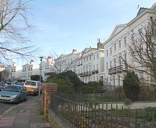
Vernon Terrace is a mid 19th-century residential development in the Montpelier suburb of Brighton, part of the English coastal city of Brighton and Hove. Construction of the first section started in 1856, and the 37-house terrace was complete in the early 1860s. Architecturally, the houses divide into five separate compositions, although all are in a similar late Regency/Italianate style. This was characteristic of houses of that era in Brighton, and especially in the Montpelier area—where the Regency style persisted much later than elsewhere. Standing opposite is the landmark Montpelier Crescent, which had a view of the South Downs until Vernon Terrace blocked it. Three groups of houses in the terrace have been listed at Grade II by English Heritage for their architectural and historical importance.
Taunton Deane is a local government district with borough status in the English county of Somerset. In the United Kingdom, the term listed building refers to a building or other structure officially designated as being of special architectural, historical or cultural significance; Grade II* structures are those considered to be "particularly significant buildings of more than local interest". Listing was begun by a provision in the Town and Country Planning Act 1947. Once listed, severe restrictions are imposed on the modifications allowed to a building's structure or its fittings. In England, the authority for listing under the Planning Act 1990 rests with Historic England, a non-departmental public body sponsored by the Department for Digital, Culture, Media and Sport; local authorities have a responsibility to regulate and enforce the planning regulations.
Hammet Street is a street in Taunton, Somerset, England, that runs between the Church of St Mary Magdalene and the town centre. It is named after Sir Benjamin Hammet, who had a bill passed through parliament to allow him to build the street in 1788. The street includes four listed buildings: numbers 4 and 5–8, 9–12, 13–17, and number 18 with 33 Fore Street. The first three buildings are grade II* listed, while the last is grade II listed, and together with the Church of St Mary Magdalene and the listed buildings in Church Square, the English Heritage consider them to "form an extremely important group."
The Masonic Hall in Taunton, Somerset, is designated by Historic England as a Grade II* listed building. It was originally built in the early 19th century as St George's Chapel, the first Roman Catholic chapel open for public worship in Taunton since the Reformation. The building, which forms the end of a terrace, features a series of prominent Ionic pilasters along the front and southern end.
The Square is a town square in Wiveliscombe, Somerset, England. It was originally used as a market place, and contains a number of listed buildings. One of these, number 5 and 7, is Grade II* listed, while five others—number 1, Castle Cottage, the cottages adjoining Castle Cottage, the Town Hall and London House—are all Grade II listed.
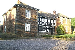
Mawdesley Hall is a country manor in Hall Lane, Mawdesley, Chorley, Lancashire, England. It consists of a central hall with two cross-wings. The central hall was built in the 17th century, its lower storey being timber-framed and its upper floor plastered and painted to resemble timber-framing. The cross-wings were added in the late 18th or early 19th century. The west wing is in sandstone, and the east wing is in brick with stone dressings. The hall is recorded in the National Heritage List for England as a designated Grade I listed building.
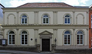
Taunton Unitarian Chapel is on Mary Street, Taunton, Somerset, England. It was built in the early 18th century as a Baptist chapel, but later adopted Unitarianism. The exterior was extensively renovated in the 19th century in an Italianate style. The chapel has been designated as a Grade II* listed building.
The Shire Hall is a municipal building in Fore Street, Hertford, the county town of Hertfordshire, England. The building, which currently serves as a Magistrates' Court, is a Grade I listed building.
Woburn Town Hall is a municipal building in the Market Place, Woburn, Bedfordshire, England. The town hall, which has largely been converted for retail use, is a Grade II listed building.
This page is based on this Wikipedia article Text is available under the CC BY-SA 4.0 license; additional terms may apply. Images, videos and audio are available under their respective licenses.