Dover is a local government district in Kent, England. It is named after its largest town, the port town of Dover. The council is based in Whitfield on the outskirts of Dover. The district also covers the towns of Deal, Sandwich and Walmer as well as the surrounding rural areas.

The White Cliffs of Dover are the region of English coastline facing the Strait of Dover and France. The cliff face, which reaches a height of 350 feet (110 m), owes its striking appearance to its composition of chalk accented by streaks of black flint, deposited during the Late Cretaceous. The cliffs, on both sides of the town of Dover in Kent, stretch for eight miles (13 km). The White Cliffs of Dover form part of the North Downs. A section of coastline encompassing the cliffs was purchased by the National Trust in 2016.

Goodwin Sands is a 10-mile-long (16 km) sandbank at the southern end of the North Sea lying 6 miles (10 km) off the Deal coast in Kent, England. The area consists of a layer of approximately 25 m (82 ft) depth of fine sand resting on an Upper Chalk platform belonging to the same geological feature that incorporates the White Cliffs of Dover. The banks lie between 0.5 m above the low water mark to around 3 m (10 ft) below low water, except for one channel that drops to around 20 m (66 ft) below. Tides and currents are constantly shifting the shoals.

Deal is a coastal town in Kent, England, which lies where the North Sea and the English Channel meet, 8 miles (13 km) north-east of Dover and 8 miles (13 km) south of Ramsgate. It is a former fishing, mining and garrison town whose history is closely linked to the anchorage in the Downs. Close to Deal is Walmer, a possible location for Julius Caesar's first arrival in Britain.
The SS Cap Lopez was a 758 GRT cargo ship that was built in 1885 as Rheinland. She was sold in 1905 and renamed, and became stranded on the south Goodwin Sands on 21 December 1907.

The Great storm of 1703 was a destructive extratropical cyclone that struck central and southern England on 26 November 1703. High winds caused 2,000 chimney stacks to collapse in London and damaged the New Forest, which lost 4,000 oaks. Ships were blown hundreds of miles off-course, and over 1,000 sea men died on the Goodwin Sands alone. News bulletins of casualties and damage were sold all over England – a novelty at that time. The Church of England declared that the storm was God's vengeance for the sins of the nation. Daniel Defoe thought it was a divine punishment for poor performance against Catholic armies in the War of the Spanish Succession.

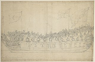
The Battle of the Downs took place on 21 October 1639, during the Eighty Years' War. A Spanish fleet, commanded by Admiral Antonio de Oquendo, was decisively defeated by a Dutch force under Lieutenant-Admiral Maarten Tromp. Victory ended Spanish efforts to re-assert naval control over the English Channel and confirmed Dutch dominance of the sea lanes, while it is also alleged to be the first major action to feature line of battle tactics.

Kingsdown is a village on the English Channel coast of Kent. Parts of the village are built on or behind the shingle beach that runs north to Deal and beyond, while other parts are on the cliffs and hills inland. The village church of St John the Evangelist was built by local landowner William Curling in 1848. Curling's former residence, Kingsdown House, was acquired by the Brightstone Holiday Centre in 1934 and a holiday camp, now known as Kingsdown Holiday Park, has operated in the grounds up to the present day. It is in the civil parish of Ringwould with Kingsdown. In 2019 it had an estimated population of 1764.

MV Ross Revenge is a radio ship, the home of Radio Caroline, as well as having supported Radio Monique and various religious broadcasters. Funded by the Icelandic government, she was constructed in Bremerhaven in 1960 and served as an Icelandic commercial trawler until 1963 when she was sold to the Ross Group fleet, notably taking part in the Cod Wars of the 1970s. Following her decommissioning, she was purchased by Radio Caroline and outfitted as a radio ship, complete with 300-foot (91 m) antenna mast and 50 kW transmitter. Her broadcasts began on 20 August 1983; her final pirate broadcast took place in November 1990. She ran aground on the Goodwin Sands in November 1991, bringing the era of offshore pirate radio in Europe to an end. She was, however, salvaged, and is now maintained by the Caroline Support Group, a group of supporters and enthusiasts.
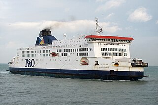
MS Pride of Canterbury was a cross-channel ferry operated by P&O Ferries between Dover, United Kingdom and Calais, France. She made her maiden voyage on 4 January 1992 as the European pathway. She was converted in 2003 to a pure passenger vessel. She retired from service on the 10 September 2023 before a brief lay up and a departure for Alaiga to be broken up for recycling
HMS Stirling Castle was a 70-gun third-rate built at Deptford Dockyard, in 1678/79. She was in active commission for the War of the English Succession, fighting in the Battles of Beachy Head and Barfleur. HMS Stirling Castle underwent a rebuild at Chatham Dockyard in 1699. She was in the Cadiz operation in 1702. The ship was wrecked on the Goodwin Sands off Deal on 27 November 1703. The remains are now a Protected Wreck managed by Historic England.

P&O Stena Line was formed in 1998 after the merger of P&O European Ferries (Dover) Ltd and the Dover and Newhaven operations of Stena Line.

A roadstead or road is a body of water sheltered from rip currents, spring tides, or ocean swell where ships can lie reasonably safely at anchor without dragging or snatching. It can be open or natural, usually estuary-based, or may be created artificially. In maritime law, it is described as a "known general station for ships, notoriously used as such, and distinguished by the name".

Tor Bay is a bay on the south-east coast of the county of Devon, England. Facing east into the English Channel, it is about 4.5 mi (7.2 km) wide from north to south. The settlements of Torquay, Paignton and Brixham, which lie along its coastline, are known collectively as Torbay.

The Harwich Force originally called Harwich Striking Force was a squadron of the Royal Navy, formed during the First World War and based in Harwich. It played a significant role in the war.

SS Mahratta was a steamship owned by Brocklebank Line which was launched in 1891 and ran aground on the Goodwin Sands in 1909.
SS Mahratta was a Brocklebank Line steamship launched in 1917. She ran aground in the English Channel on the Goodwin Sands in October 1939. She was the second and final Brocklebank Line ship with this name. The first Mahratta suffered a similar fate in 1909. After Mahratta broke up, the ship was found to be resting on top of the first Mahratta.
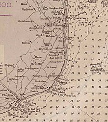
The Downs Station also known as the Commander-in-Chief, the Downs or Admiral Commanding at the Downs was a formation of the Kingdom of Great Britain and then the United Kingdom's Royal Navy based at Deal. It was a major command of the Royal Navy from 1626 until 1834.

Yarmouth Roads is a coastal feature in Norfolk, England that was used by merchant and naval ships as an anchorage or roadstead off Great Yarmouth.
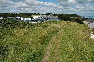
Ringwould with Kingsdown is a coastal civil parish in the Dover District of Kent, England. The parish contains the villages of Ringwould and Kingsdown.